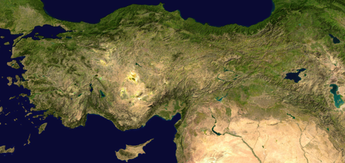
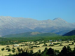
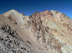
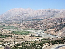
List of mountains in Turkey

Last updated

Geographic view of Turkey Anatolia composite NASA.png
Geographic view of Turkey
Mountain ranges and tectonic faults of Turkey Mountain systems of Turkey.svg
Mountain ranges and tectonic faults of Turkey

Mountain ranges of Turkey

Mountains of Turkey

List of Mountains in Turkey
NameAltitudeMountain RangeCoordinates
Büyük Ağrı (Mount Ararat)5,137 m (16,854 ft)Ağrı 39°42′09″N44°18′00″E / 39.70250°N 44.30000°E / 39.70250; 44.30000 (Büyük Ağrı)
Gelyansın or Uludoruk (Reşko Tepesi)4,134 m (13,563 ft) Taurus 37°29′09″N44°00′18″E / 37.48583°N 44.00500°E / 37.48583; 44.00500 (Uludoruk)
Cilo Dağı 4,116 m [1] (13,504 ft) Taurus
Süphan 4,058 m (13,314 ft) 38°55′54″N42°50′03″E / 38.93167°N 42.83417°E / 38.93167; 42.83417 (Süphan)
Kaçkar Dağı highest peak in Kaçkarlar 3,932 m (12,900 ft) Kaçkarlar 40°50′12″N41°09′48″E / 40.83667°N 41.16333°E / 40.83667; 41.16333 (Kaçkar Dağı)
Erciyes (Mount Erciyes)3,916 m (12,848 ft)Central Anatolia Region 38°32′06″N35°27′03″E / 38.53500°N 35.45083°E / 38.53500; 35.45083 (Erciyes)
Küçük Ağrı (Lesser Ararat, Little Ararat, Mount Sis)3,896 m (12,782 ft)Ağrı 39°39′N44°24′E / 39.650°N 44.400°E / 39.650; 44.400 (Küçük Ağrı)
Handeyade (Catalkaya, Samdi)3,794 m (12,448 ft)Cilo-Sat 37°19′N44°15′E / 37.31°N 44.25°E / 37.31; 44.25 (Küçük Ağrı)
Kızılkaya Highest Peak in Anti-Taurus Mountains (Aladağlar)3,767 m (12,359 ft) Aladağlar
Büyük Demirkazık (Greater Demirkazık)3,756 m (12,323 ft) Aladağlar 37°47′51″N35°09′33″E / 37.79750°N 35.15917°E / 37.79750; 35.15917 (Büyük Demirkazık)
Kısara3,752 m (12,310 ft)Cilo-Sat
Mazanı3,725 m (12,221 ft)Cilo-Sat
Emler3,723 m (12,215 ft) Aladağlar 37°48′23″N35°08′55″E / 37.8065°N 35.1486°E / 37.8065; 35.1486 (Emler)
Verçenik3,711 m (12,175 ft) Kaçkarlar
Kaldı3,688 m (12,100 ft) Aladağlar
Başet Tepesi [2] (Gürpınar, Van)3,684 m (12,087 ft)İhtiyar Şahap Mountains
Şilan Mountains 3,670 m (12,040 ft)Cilo-Sat
Kızılyar3,654 m (11,988 ft) Aladağlar
Gürtepe3,630 m (11,910 ft) Aladağlar
Sematepe3,623 m (11,886 ft) Aladağlar
Çağalın Başı3,612 m (11,850 ft) Aladağlar
Mount Tendürek 3,584 m (11,759 ft)
Torasan3,584 m (11,759 ft) Aladağlar
Alaca (Lorut)3,582 m (11,752 ft) Aladağlar
Vayvay3,563 m (11,690 ft) Aladağlar
Bulut3,562 m (11,686 ft) Kaçkarlar
Eznevit3,560 m (11,680 ft) Aladağlar
Karasay3,550 m (11,650 ft) Aladağlar
Mount Artos 3,550 m (11,650 ft)İhtiyar Şahap Mountains
Boruklu3,548 m (11,640 ft) Aladağlar
Gevaruk3,540 m (11,610 ft)Cilo-Sat
Çandır Dağı 3,537 m (11,604 ft)
Güngörmez3,536 m (11,601 ft) Kaçkarlar
Sulağankaya3,530 m (11,580 ft) Aladağlar
Soğanlı Dağ3,527 m (11,572 ft) Kaçkarlar
Medetsiz Highest peak in Bolkar Mountains 3,524 m (11,562 ft) Bolkar Mountains
unnamed near Çağalın Başı3,517 m (11,539 ft) Aladağlar
Direktaş3,510 m (11,520 ft) Aladağlar
Orta Dağ3,500 m (11,500 ft) Aladağlar
Karataş3,495 m (11,467 ft) Kaçkarlar
Keşif3,475 m (11,401 ft) Bolkar Mountains
Cebelbaşı3,474 m (11,398 ft) Aladağlar
Liblin Tepe3,472 m (11,391 ft) Kaçkarlar
Karasay3,472 m (11,391 ft) Aladağlar
Güzeller3,461 m (11,355 ft) Aladağlar
Kösedağ Dağı 3,433 m (11,263 ft) 39°53′43″N42°38′37″E / 39.89528°N 42.64361°E / 39.89528; 42.64361 (Kösedağ)
Sıyırmalık3,426 m (11,240 ft) Aladağlar
Tearzin3,415 m (11,204 ft)Cilo-Sat
Küçük Demirkazık 3,400 m (11,200 ft) Aladağlar
Tahtakaya3,372 m (11,063 ft) Bolkar Mountains
Didvake3,350 m (10,990 ft) Kaçkarlar
Büyük Dağ Tepe3,328 m (10,919 ft) Kaçkarlar
Sat Başı3,302 m (10,833 ft)Cilo-Sat
Altıparmak3,301 m (10,830 ft) Kaçkarlar
Marsis3,300 m (10,800 ft) Kaçkarlar
Kardal3,300 m (10,800 ft)Cilo-Sat
Hasan Dağı 3,253 m (10,673 ft) 38°08′N34°11′E / 38.133°N 34.183°E / 38.133; 34.183 (Hasan Dağı)
Mescit Mountains 3,239 m (10,627 ft)
Bingöl Mountains 3,193 m (10,476 ft)

39°21′35″N41°22′56″E / 39.35972°N 41.38222°E / 39.35972; 41.38222 (Bingöl)

Contents

Büyük Ejder 3,176 m (10,420 ft)
Erek Dağı 3,175 m (10,417 ft) 38°28′N43°30′E / 38.467°N 43.500°E / 38.467; 43.500 (Erek Dağı)
Kargapazarı Mountains 3,169 m (10,397 ft)
Nurhak Dağı3,081 m (10,108 ft)
Kızlar Sivrisi 3,069 m (10,069 ft) Beydağları
Çakmak Mountain 3,063 m (10,049 ft)
Nemrut 3,050 m (10,010 ft) 39°25′N41°31′E / 39.41°N 41.51°E / 39.41; 41.51 (Nemrut)
Akdoğan 2,879 m (9,446 ft) Akdoğan Mountains 39°11′05″N41°51′42″E / 39.18472°N 41.86167°E / 39.18472; 41.86167 (Akdoğan)
Kösedağ Dağı 2,794 m (9,167 ft) 40°04′38″N37°58′18″E / 40.07722°N 37.97167°E / 40.07722; 37.97167 (Kösedağ)
Şerafettin 2,675 m (8,776 ft)

39°02′22″N41°11′57″E / 39.03944°N 41.19917°E / 39.03944; 41.19917 (Şerafettin)

Göztepe 2,594 m (8,510 ft) Akdoğan Mountains 39°06′46″N41°50′47″E / 39.11278°N 41.84639°E / 39.11278; 41.84639 (Göztepe)
Mount Honaz 2,571 m (8,435 ft)
Uludağ 2,543 m (8,343 ft) 40°04′10″N29°13′17″E / 40.06944°N 29.22139°E / 40.06944; 29.22139 (Uludağ)
Cemalverdi Mountains 2,438 m (7,999 ft) 39°18′09″N42°37′32″E / 39.30250°N 42.62556°E / 39.30250; 42.62556 (Cemalverdi)
Tahtalı 2,366 m (7,762 ft)Beydağları 36°32′13″N30°26′31″E / 36.53694°N 30.44194°E / 36.53694; 30.44194
Ahır 2,344 m (7,690 ft) Southeastern Taurus Mountains 37°39′N37°02′E / 37.65°N 37.03°E / 37.65; 37.03
Murat Mountain 2,312 m (7,585 ft)
Karadağ 2,271 m (7,451 ft) 37°15′N33°05′E / 37.25°N 33.08°E / 37.25; 33.08 (Karadağ)
Girekol 2,145 m (7,037 ft) 39°06′14″N43°25′34″E / 39.104°N 43.426°E / 39.104; 43.426 (Girekol)
Şaphane mountain 2,120 m (6,960 ft)
Kazdağı (Mount Ida)1,770 m 39°42′N26°50′E / 39.700°N 26.833°E / 39.700; 26.833
Spil Dağı 1,517 m (4,977 ft)
Madra Mountains 1,230 m Aegean Region
Mahya Dağı 1,031 m (3,383 ft) Yıldız Mountains 41°47′N27°37′E / 41.783°N 27.617°E / 41.783; 27.617 (Mahya Dağı)

Related Research Articles

<span class="mw-page-title-main">Geography of Turkey</span> Overview of the geography of Turkey

The Anatolian side of Turkey is the largest portion in the country that bridges southeastern Europe and west Asia. East Thrace, the European portion of Turkey comprises 3% of the country and 10% of its population. East Thrace is separated from Asia Minor, the Asian portion of Turkey, by the Bosporus, the Sea of Marmara and the Dardanelles. İskilip, Çorum province, is considered to be the geographical center of Earth. Turkey is very vulnerable to earthquakes.

<span class="mw-page-title-main">Taurus Mountains</span> Mountain range in southern Turkey

The Taurus Mountains are a mountain complex in southern Turkey, separating the Mediterranean coastal region from the central Anatolian Plateau. The system extends along a curve from Lake Eğirdir in the west to the upper reaches of the Euphrates and Tigris rivers in the east. It is a part of the Alpide belt in Eurasia.

<span class="mw-page-title-main">Anti-Taurus Mountains</span> Mountain range in southern and eastern Turkey

The Anti-Taurus Mountains or Aladaglar are a mountain range in southern and eastern Turkey, curving northeast from the Taurus Mountains.

<span class="mw-page-title-main">Armenian highlands</span> Elevated plateau in northern West Asia

The Armenian highlands is the most central and the highest of the three plateaus that together form the northern sector of West Asia. Clockwise starting from the west, the Armenian highlands are bounded by the Anatolian plateau, the Caucasus, the Kura-Aras lowlands, the Iranian Plateau, and Mesopotamia. The highlands are divided into western and eastern regions, defined by the Ararat Valley where Mount Ararat is located. Western Armenia is nowadays referred to as eastern Anatolia, and Eastern Armenia as the Lesser Caucasus or Caucasus Minor, and historically as the Anti-Caucasus, meaning "opposite the Caucasus".

<span class="mw-page-title-main">Mount Hasan</span> Volcano in Turkey

Mount Hasan is a volcano in Anatolia, Turkey. It has two summits, the 3,069 metres (10,069 ft) high eastern Small Hasan Dagi and the 3,253 metres (10,673 ft) high Big Hasan Dagi, and rises about 1 kilometre (0.62 mi) above the surrounding terrain. It consists of various volcanic deposits, including several calderas, and its activity has been related to the presence of several faults in the area and to regional tectonics.

<span class="mw-page-title-main">Nemrut (volcano)</span> Volcano in Turkey

Nemrut is a dormant volcano in Tatvan district, Bitlis province, Eastern Turkey, close to Lake Van. The volcano is named after King Nimrod who is said to have ruled this area in about 2100 BC.

<span class="mw-page-title-main">Anatolian Plateau</span> Inner part of Asia Minor Highlands in Turkey

<span class="mw-page-title-main">Mount Kaçkar</span> Highest peak of the Kaçkar Mountains in Turkey

Mount Kaçkar, with an elevation of 3,937 meters, is the highest peak in the Kaçkar Mountains. The mountain may be climbed by the northeast ridge route beginning from the village Yukarı Kavrun.

<span class="mw-page-title-main">Pontic Mountains</span> Mountain range in northern Anatolia, Turkey

The Pontic Mountains or Pontic Alps form a mountain range in northern Anatolia, Turkey. They are also known as the Parhar Mountains in the local Turkish and Pontic Greek languages. The term Parhar originates from a Hittite word meaning "high" or "summit". In ancient Greek, the mountains were called the Paryadres or Parihedri Mountains.

<span class="mw-page-title-main">Black Sea Region</span> Region of Turkey

The Black Sea Region is a geographical region of Turkey. The largest city in the region is Samsun. Other big cities are Zonguldak, Trabzon, Ordu, Tokat, Giresun, Rize, Amasya and Sinop.

<span class="mw-page-title-main">Eastern Anatolia Region</span> Region of Turkey

The Eastern Anatolia Region is a geographical region of Turkey. The most populous province in the region is Van Province. Other populous provinces are Malatya, Erzurum and Elazığ.

<span class="mw-page-title-main">Mediterranean Region, Turkey</span> Region of Turkey

The Mediterranean Region is a geographical region of Turkey. The largest city in the region is Antalya. Other big cities are Adana, Mersin and Kahramanmaraş.

<span class="mw-page-title-main">Geology of Turkey</span> Overview of the geology of Turkey

The geology of Turkey is the product of a wide variety of tectonic processes that have shaped Anatolia over millions of years, a process which continues today as evidenced by frequent earthquakes and occasional volcanic eruptions.

<span class="mw-page-title-main">Flora of Turkey</span> Plants that grow in the Eurasian country

As of 2000 about 9300 species of vascular plant were known to grow in Turkey. By comparison, Europe as a whole contains only about 24% more species, despite having thirteen times the area.

<span class="mw-page-title-main">Aintab plateau</span>

Aintab plateau or Gaziantep plateau is a low, gently undulating plateau that forms the westernmost part of the Southeastern Anatolia Region in Turkey. It forms the northwestern end of the Arabian Plate where it meets the Anatolian Plate at the East Anatolian Fault. The plateau lies in the Turkish provinces of Gaziantep, Kilis, and Adıyaman. In Classical Antiquity, this was the region of Commagene. Gaziantep (Aintab) is located nearly in the south-center of the plateau.

<span class="mw-page-title-main">Eastern Anatolian montane steppe</span>

The Eastern Anatolian montane steppe is a temperate grasslands, savannas, and shrublands ecoregion. It is located in the Armenian Highlands, covering parts of eastern Turkey, Armenia, Azerbaijan, southern Georgia, and northwestern Iran.

<span class="mw-page-title-main">Tahtalı Mountain Range</span> Mountain range in Turkey

The Tahtalı Mountain Range (Turkish)) Tahtalı Dağları are located in the Central Anatolian area of Turkey. It lies in the middle of the Taurus Mountains, mostly between the provinces of Kayseri, Adana, with smaller areas within the provinces of Sivas and Kahramanmaraş.

<span class="mw-page-title-main">Mount Erciyes</span> Volcano in Turkey

Mount Erciyes, also known as Argaeus, its etymon, is an inactive volcano in Kayseri Province, Turkey. It is a large stratovolcano surrounded by many monogenetic vents and lava domes, and one maar. The bulk of the volcano is formed by lava flows of andesitic and dacitic composition. At some time in the past, part of the summit collapsed towards the east.

<span class="mw-page-title-main">Anatolian Biogeographic Region</span>

The Anatolian Biogeographic Region is a biogeographic region of Turkey, as defined by the European Environment Agency.

References

  1. Azzoni, Roberto Sergio; Bollati, Irene; Pelfini, Manuela; Akif Sarıkaya, Mehmet; Zerboni, Andrea (2021-04-01). "Evolution of recently deglaciated high mountain landforms in the Eastern Anatolia": EGU21–7086. Bibcode:2021EGUGA..23.7086A. doi: 10.5194/egusphere-egu21-7086 . hdl: 2434/822081 .{{cite journal}}: Cite journal requires |journal= (help)
  2. Adım Adım Türkiye Yol Atlası ve Rehberi, Medmedya Yayınları, Istanbul, October 2010, p.134, ISBN   978-975-9137-31-1