
Mongolia is a landlocked country in Central Asia and East Asia, located between China and Russia. The terrain is one of mountains and rolling plateaus, with a high degree of relief. The total land area of Mongolia is 1,564,116 square kilometres. Overall, the land slopes from the high Altai Mountains of the west and the north to plains and depressions in the east and the south. The Khüiten Peak in extreme western Mongolia on the Chinese border is the highest point. The lowest point is at 560 m (1,840 ft), is the Hoh Nuur or lake Huh. The country has an average elevation of 1,580 m (5,180 ft).

The Altai Mountains, also spelled Altay Mountains, are a mountain range in Central and East Asia, where Russia, China, Mongolia and Kazakhstan converge, and where the rivers Irtysh and Ob have their headwaters. The massif merges with the Sayan Mountains in the northeast, and gradually becomes lower in the southeast, where it merges into the high plateau of the Gobi Desert. It spans from about 45° to 52° N and from about 84° to 99° E.

A rain shadow is an area of significantly reduced rainfall behind a mountainous region, on the side facing away from prevailing winds, known as its leeward side.
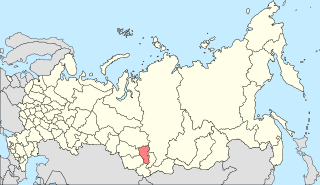
Khentii is one of the 21 aimags (provinces) of Mongolia, located in the east of the country. Its capital is Chinggis City. The aimag is named after the Khentii Mountains. It is best known as the birthplace and likely final resting place of Temüjin, otherwise known as Genghis Khan.
The Hinggan League is a prefecture-level subdivision of the Inner Mongolia Autonomous Region of the People's Republic of China. It borders Hulun Buir to the north, the Republic of Mongolia and Xilingol League to the west, Tongliao to the south and the provinces of Jilin and Heilongjiang to the east. The name is derived from the Greater Khingan mountain range that crosses the league from the northwest to the southeast.

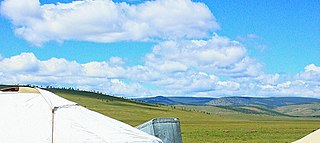
The Eurasian Steppe, also simply called the Great Steppe or the steppes, is the vast steppe ecoregion of Eurasia in the temperate grasslands, savannas, and shrublands biome. It stretches through Hungary, Bulgaria, Romania, Moldova, Ukraine, Western Russia, Siberia, Kazakhstan, Xinjiang, Mongolia, and Manchuria, with one major exclave, the Pannonian steppe or Puszta, located mostly in Hungary.

The Trigo Mountains are a north-south trending mountain range in La Paz County, Arizona, bordering the Colorado River on the east in the Lower Colorado River Valley. The range lies north of the Colorado River as it turns east, north of Martinez Lake and the Imperial Reservoir. The Trigo Mountains are on a north-south stretch of the Colorado River, and form the eastern perimeter of the Imperial National Wildlife Refuge.
South Central Siberia is a geographical region north of the point where Russia, China, Kazakhstan and Mongolia come together.

The Gobi Desert is a large desert or brushland region in East Asia. It covers parts of Northern and Northeastern China and of Southern Mongolia. The desert basins of the Gobi are bounded by the Altai Mountains and the grasslands and steppes of Mongolia on the north, by the Taklamakan Desert to the west, by the Hexi Corridor and Tibetan Plateau to the southwest and by the North China Plain to the southeast.

The Arizona transition zone is a diagonal northwest-by-southeast region across central Arizona. The region is a transition from the higher-elevation Colorado Plateau in Northeast Arizona and the Basin and Range region of lower-elevation deserts in the southwest and south.
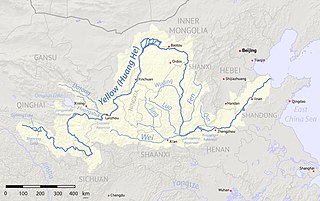
The Ordos Plateau, also known as the Ordos Basin or simply the Ordos, is a highland sedimentary basin in northwest China with an elevation of 1,000–1,600 m (3,300–5,200 ft), and consisting mostly of land enclosed by the Ordos Loop, a large northerly rectangular bend of the Yellow River. It is China's second largest sedimentary basin with a total area of 370,000 km2 (140,000 sq mi), and includes territories from five provinces, namely Shaanxi, Gansu, Ningxia, Inner Mongolia and a thin fringe of Shanxi, but is demographically dominated by the former three, hence is also called the Shaan-Gan-Ning Basin. The basin is bounded in the east by the Lüliang Mountains, north by the Yin Mountains, west by the Helan Mountains, and south by the Huanglong Mountains, Meridian Ridge and Liupan Mountains.

The Granite Wash Mountains are a short, arid, low elevation mountain range of western-central Arizona, in the southeast of La Paz County. The range borders a slightly larger range southeast, the Little Harquahala Mountains; both ranges form a section on the same water divide between two desert washes. The washes flow in opposite directions, one northwest to the Colorado River, the other southeast to the Gila River.
The West Silver Bell Mountains are a small 10 mile (16 km) long mountain range of south-central Arizona, United States. The range lies in the north-central arid Sonoran Desert; the Madrean Sky Islands region of southeast Arizona, around Tucson is adjacent to the southeast.
The Alborz range, also spelled as Alburz, Elburz or Elborz, is a mountain range in northern Iran that stretches from the border of Azerbaijan along the western and entire southern coast of the Caspian Sea and finally runs northeast and merges into the smaller Aladagh Mountains and borders in the northeast on the parallel mountain ridge Kopet Dag in the northern parts of Khorasan. All these mountains are part of the much larger Alpide belt. This mountain range is divided into the Western, Central, and Eastern Alborz Mountains. The Western Alborz Range runs south-southeastward almost along the western coast of the Caspian Sea. The Central Alborz runs from west to east along the entire southern coast of the Caspian Sea, while the Eastern Alborz Range runs in a northeasterly direction, toward the northern parts of the Khorasan region, southeast of the Caspian Sea. Mount Damavand, the highest mountain in Iran measuring 5,610.0 m, is located in the Central Alborz Mountains.

The Painted Rocks Mountains are a short 15-mile (24 km) long mountain range of the north-central Sonoran Desert southwest of Phoenix, Arizona and in southwest Maricopa County. The Gila River flows through the central-north end of the range.

The Altai montane forest and forest steppe ecoregion covers patches of the subalpine forest belt on the Altai Mountains, crossing the border region where Russia, Kazakhstan, Mongolia and China meet. The region has high biodiversity, as it is located in transition zones between different ecoregions, altitudes, and climate zones. It is in the Palearctic realm, with a Cold semi-arid climate. It covers 35,199,998 km2 (13,590,795 sq mi).

The Sayan montane conifer forests ecoregion covers the mid-elevation levels of the Sayan Mountains, the high mountain range between the taiga of Siberia, Russia to the north, and the steppes of Mongolia to the south. The slopes of the mountains at the mid-altitudes are covered by Temperate coniferous forest. The ecoregion is in the Palearctic realm, with a cold semi-arid climate. It covers 35,741,835 km2 (13,800,000 sq mi).

The Altai alpine meadow and tundra ecoregion is a terrestrial ecoregion covering the higher elevation of the Altai Mountains at the center of the "X" formed by the borders separating Russia, Kazakhstan, China, and Mongolia. The mountain peaks are the farthest north in Central Asia, separating the plains of Siberia to the north from the hot, dry deserts to the south. Altitudes above 2,400 meters display characteristics of tundra, with patches of alpine meadows and some trees immediately below the treeline. The ecoregion is in the montane grasslands and shrublands biome, and the Palearctic realm, with a humid continental climate. It covers an area of 90,132 square kilometres (34,800 sq mi).

