Related Research Articles
The protected areas of the Northern Territory consists of protected areas managed by the governments of the Northern Territory and Australia and private organisations with a reported total area of 335,527 square kilometres (129,548 sq mi) being 24.8% of the total area of the Northern Territory of Australia.

The Sand Creek massacre was a massacre of Cheyenne and Arapaho people by the U.S. Army in the American Indian Wars that occurred on November 29, 1864, when a 675-man force of the Third Colorado Cavalry under the command of U.S. Volunteers Colonel John Chivington attacked and destroyed a village of Cheyenne and Arapaho people in southeastern Colorado Territory, killing and mutilating an estimated 70 to over 600 Native American people. Chivington claimed 500 to 600 warriors were killed. However, most sources estimate around 150 people were killed, about two-thirds of whom were women and children. The location has been designated the Sand Creek Massacre National Historic Site and is administered by the National Park Service. The massacre is considered part of a series of events known as the Colorado Wars.
Gija, also spelt Gidja and Kija, alternatively known as the Lungga, refers to Aboriginal Australians from the East Kimberley area of Western Australia, about 200 kilometres (120 mi) south of Kununurra. In the late 19th century pastoralists were fiercely resisted by Gija people, many of whom now live around localities such as Halls Creek and Warmun.
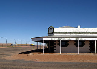
Birdsville is a rural town and locality in the Shire of Diamantina, Queensland, Australia. The locality is on the Queensland border with both the Northern Territory and South Australia. The town is situated 10 kilometres (6 mi) north of the South Australian border. In the 2021 census, the locality of Birdsville had a population of 110 people.
The Northern Territory Police Force is the police body that has legal jurisdiction over the Northern Territory of Australia. This police service has 1,607 police members made up of 83 senior sergeants, 228 sergeants, 912 constables, 220 auxiliaries, and 64 Aboriginal Community Police Officers. The rest of the positions are members of commissioned rank and inoperative positions. It also has a civilian staff working across the NT Police, Fire and Emergency Services.
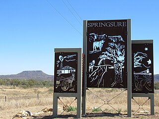
Springsure is a rural town and locality in the Central Highlands Region, Queensland, Australia. In the 2021 census, the locality of Springsure had a population of 950 people.

The Myall Creek massacre was the killing of at least 28 unarmed Aboriginal people in the Colony of New South Wales by eight colonists on 10 June 1838 at the Myall Creek in the north of the colony. Seven perpetrators were convicted of murder and hanged.
Barrow Creek is a very small town, with a current population of 11, in the southern Northern Territory of Australia. It is located on the Stuart Highway, about 280 km north of Alice Springs, about halfway from there to Tennant Creek. The main feature of the town is the roadhouse/hotel. A number of mining companies are currently exploring in the area, although none of the current residents are involved in the mining industry.
Warrigal Creek is the site of an 1843 massacre of Gunai/Kurnai people in colonial Victoria, during the Australian frontier wars. The creek is on a farm 40 kilometres (25 mi) south of Sale, and 200 kilometres (120 mi) east of Melbourne, in the South Gippsland area of Victoria, Australia.

The Fitzroy River, also known as Martuwarra, is located in the West Kimberley region of Western Australia. It has 20 tributaries and its catchment occupies an area of 93,829 square kilometres (36,228 sq mi), within the Canning Basin and the Timor Sea drainage division.

The Shire of Derby–West Kimberley is one of four local government areas in the Kimberley region of northern Western Australia, covering an area of 104,080 square kilometres (40,186 sq mi), most of which is sparsely populated. The Shire's population as at the 2016 Census was almost 8,000, with most residing in the major towns of Derby, which is also the Shire's seat of government, and Fitzroy Crossing. There are also around 70 Aboriginal communities within the Shire.
The following lists events that happened during 1916 in Australia.
The Forrest River massacre was a massacre of Indigenous Australian people by a group of law enforcement personnel and civilians in June 1926, in the wake of the killing of a pastoralist in the Kimberley region of Western Australia.
The Richmond River massacres were a series of murders of groups of Indigenous Australians and European Australians in the region around the Richmond River in north-eastern New South Wales in the mid-nineteenth century.

The Battle of Mud Springs took place February 4–6, 1865, in Nebraska between the U.S. army and warriors of the Lakota Sioux, Cheyenne, and Arapaho tribes. It was part of a series of retaliations by the Native American alliance after the U.S. army committed the Sand Creek Massacre. The battle was inconclusive, although the Indians succeeded in capturing some Army horses and a herd of several hundred cattle. Mud Springs is located 8 mi northwest of Dalton, Nebraska, and is today a National Historic Site.
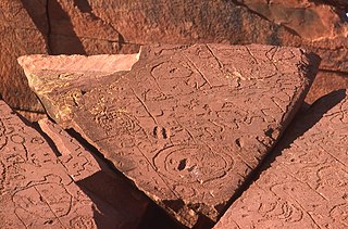
Bedford Downs, or Bedford Downs Station, is a pastoral lease that operates as a cattle station in Western Australia.
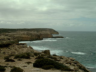
The Waterloo Bay massacre, also known as the Elliston massacre, was a clash between European settlers and Aboriginal Australians that took place on the cliffs of Waterloo Bay near Elliston, South Australia, in late May 1849. Part of the Australian frontier wars, the most recent scholarship indicates that it is likely that it resulted in the deaths of tens or scores of Aboriginal people. The events leading up to the fatal clash included the killings of three European settlers by Aboriginal people, the killing of one Aboriginal person, and the death by poisoning of five others by European settlers. The limited archival records indicate that three Aboriginal people were killed or died of wounds from the clash and five were captured, although accounts of the killing of up to 260 Aboriginal people at the cliffs have circulated since at least 1880.
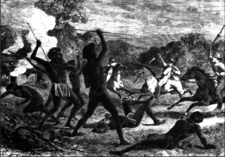
Myall Creek Massacre and Memorial Site is the heritage-listed site of and memorial for the victims of the Myall Creek massacre at Bingara Delungra Road, Myall Creek, Gwydir Shire, New South Wales, Australia. The memorial, which was unveiled in 2000, was added to the Australian National Heritage List on 7 June 2008 and the New South Wales State Heritage Register on 12 November 2010.
Myall Creek is a rural locality split between the local government areas of Inverell Shire and the Gwydir Shire in New South Wales, Australia. In the 2021 census, Myall Creek had a population of 27.
References
- 1 2 Davis, Therese; Moreton, Romaine (2013). "Indigenous Performance of History, Loss and Remembrance Inwhispering in Our Hearts". Interventions. 15 (2): 211–223. doi:10.1080/1369801x.2013.798472. ISSN 1369-801X. S2CID 161599168.
- ↑ "Australian Web Archive". Archived from the original on 2 September 2011.
- ↑ "Mowla Bluff Massacre". Monument Australia. Retrieved 14 April 2019.