Transport in Tanzania includes road, rail, air and maritime networks. The road network is 86,472 kilometres (53,731 mi) long, of which 12,786 kilometres (7,945 mi) is classified as trunk road and 21,105 kilometres (13,114 mi) as regional road. The rail network consists of 3,682 kilometres (2,288 mi) of track. Commuter rail service is in Dar es Salaam only. There are 28 airports, with Julius Nyerere International being the largest and the busiest. Ferries connect Mainland Tanzania with the islands of Zanzibar. Several other ferries are active on the countries' rivers and lakes.
This article is about the Transport in Zambia.
Mbala is Zambia's most northerly large town and seat of Mbala District in Northern Province, occupying a strategic location close to the border with Tanzania and controlling the southern approaches to Lake Tanganyika, 40 km by road to the north-west, where the port of Mpulungu is located. It had a population of about 20,000 in 2006. Under the name Abercorn, Mbala was a key outpost in British colonial control of this part of south-central Africa.

An inland port is a port on an inland waterway, such as a river, lake, or canal, which may or may not be connected to the sea. The term "inland port" is also used to refer to a dry port.

Kigoma is a city and lake port in Kigoma-Ujiji District in Tanzania, on the northeastern shores of Lake Tanganyika and close to the border with Burundi and The Democratic Republic of the Congo. It serves as the capital for the surrounding Kigoma Region and has a population of 232,388. The city is situated at an elevation of 775 metres (2,543 ft).

Northern Province is one of Zambia's ten provinces. It covers approximately one-sixth of Zambia in land area. The provincial capital is Kasama. The province is made up of 12 districts, namely Kasama District, Chilubi District, Kaputa District, Luwingu District, Mbala District, Mporokoso District, Mpulungu District, Mungwi District, Nsama District, Lupososhi District, Lunte District and Senga Hill District. Currently, only Kasama and Mbala have attained municipal council status, while the rest are still district councils. It is widely considered to be the heartland of the Bemba, one of the largest tribes in Zambia.
Kalemie, formerly Albertville or Albertstad, is a city on the western shore of Lake Tanganyika in the Democratic Republic of the Congo. The Lukuga River, that drains Lake Tanganyika to the Lualaba River, runs through the city. Kalemie is the capital of Tanganyika Province.
Kasanga, known as Bismarckburg during the German colonial rule, is a town in Rukwa Region, Tanzania. It is located at around 8°27′30″S31°8′10″E, on the shore of Lake Tanganyika, 810 m above sea level.

MV Liemba, formerly Graf Goetzen or Graf von Goetzen, is a passenger and cargo ferry that runs along the eastern shore of Lake Tanganyika. The Marine Services Company Limited of Tanzania sails her, with numerous stops to pick up and set down passengers, between the ports of Kigoma, Tanzania and Mpulungu, Zambia.
The Lungu are a tribe of two Bantu ethnic groups i.e. the Lungu of Chief Tafuna (Mambwe-Lungu) and the Lungu of Chief Mukupa Kaoma (Malaila-Lungu). The Mambwe Lungu, who are the main focus of this article are located primarily on the southwestern shores of Lake Tanganyika in Rukwa Region's Kalambo District, Tanzania and northeastern Zambia mainly in Mpulungu and Mbala district. In 1987 the Lungu population in Tanzania was estimated to number 34,000. The number of Lungu in Zambia has not been independently estimated, though the combined number of Mambwe and Lungu in Zambia was estimated to be 262,800 in 1993.

MV Mwongozo is a mixed passenger and cargo ferry on Lake Tanganyika operated by the Marine Services Company Limited. She can carry up to 800 passengers and 80 tons of cargo. Her accommodation includes open sleeping areas, individual cabins and a passenger dining saloon. She can take cars and small trucks on her forward deck.

Nsumbu National Park lies on the western shore of Lake Tanganyika near its southern extremity, in Zambia's Northern Province. It covers about 2000 km2 and has some 80 km of lake shore including four bays, and Nundo Head Peninsula.

The Congo Pedicle road crosses the Congolese territory of the Congo Pedicle and was constructed by and is maintained by Zambia to connect its Copperbelt and Luapula Provinces. Both the road and the territory may be referred to as ‘the Pedicle’. It is designated as the N36 Route on the Congolese Road Network.
Water transport and the many navigable inland waterways in Zambia have a long tradition of practical use except in parts of the south. Since draught animals such as oxen were not heavily used, water transport was usually the only alternative to going on foot until the 19th century. The history and current importance of Zambian waterways, as well as the types of indigenous boats used, provide information on this important aspect of Zambian economy.
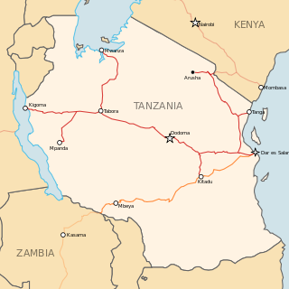
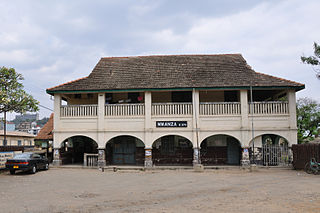
Railway stations in Tanzania include:

Tanzania Ports Authority (TPA) is a parastatal public corporation acting under the aegis of the Ministry of Infrastructure Development, that has the responsibility "to manage and operate" the ocean ports and lake ports of the country of Tanzania. The Tanzania Ports Authority headquarters are located in Mchafukoge ward of Ilala District in Dar es Salaam Region. It is a member of the Port Management Association of Eastern and Southern Africa.

The Royal East African Navy was a unified naval force of the former British colonies of Kenya, Tanganyika, Uganda, and Zanzibar. It was the colonial forerunner of the Kenyan Navy and Tanzanian Navy. Formed in 1953, it was disbanded on 30 June 1962.
Rail transport in Tanzania began in the late 19th century.
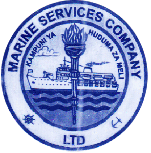
Marine Services Company Limited (MSCL) is a Tanzanian company that operates ferries, cargo ships and tankers on three of the African Great Lakes, namely Lake Victoria, Lake Tanganyika and Lake Nyasa. It provides services to neighbouring Burundi, DR Congo, Zambia and Malawi.
The Port of Bujumbura is a port on Lake Tanganyika serving the city of Bujumbura, Burundi.

