Muggins Mountains

Last updated
Muggins Mountains

Morgan Peak in the Muggins Mountains.jpg

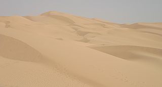
Morgan Peak in the Muggins Mountains
(peak in the distant background)
Foreground-base of mountains-adjacent cliffs of wash; in view: gray-green Psorothamnus , deep-green Acacia greggii -(catclaw), blue palo verdes, and straw-colored Bebbia juncea
Highest point
Peak unnamed
Elevation 1,908 ft (582 m)
Geography
Country United States
State Arizona

The Muggins Mountains is a mountain range in southwest Arizona east of Yuma, Arizona, northeast of the Gila Mountains, and east of the Laguna Mountains. The Castle Dome Mountains lie to the northeast across the broad Castle Dome Plain. The Muggins Mountains Wilderness occupies the southwest portion of the range. [1]

Mountain range A geographic area containing several geologically related mountains

A mountain range or hill range is a series of mountains or hills ranged in a line and connected by high ground. A mountain system or mountain belt is a group of mountain ranges with similarity in form, structure, and alignment that have arisen from the same cause, usually an orogeny. Mountain ranges are formed by a variety of geological processes, but most of the significant ones on Earth are the result of plate tectonics. Mountain ranges are also found on many planetary mass objects in the Solar System and are likely a feature of most terrestrial planets.

Arizona state of the United States of America

Arizona is a state in the southwestern region of the United States. It is also part of the Western and the Mountain states. It is the sixth largest and the 14th most populous of the 50 states. Its capital and largest city is Phoenix. Arizona shares the Four Corners region with Utah, Colorado, and New Mexico; its other neighboring states are Nevada and California to the west and the Mexican states of Sonora and Baja California to the south and southwest.

Yuma, Arizona City in Arizona, United States

Yuma is a city in and the county seat of Yuma County, Arizona, United States. The city's population was 93,064 at the 2010 census, up from the 2000 census population of 77,515.

Contents

The Muggins Mountains are a triangular block about 10 mi (16 km) on the SW and SE sides and 14 mi (23 km) on the north side. [2] The northern half of the mountain range has the two high peaks of the range: the unnamed northwest at 1,908 feet (582 m) and the northeast, Red Bluff Mountain at 1,905 feet (581 m). [1] The northern of the range is within the Yuma Proving Ground. [1]

Yuma Proving Ground military facility

Yuma Proving Ground (YPG) is a United States Army proving ground and one of the largest military installations in the world. It is a subordinate command of the Army Test and Evaluation Command.

The southern portion of the range is bordered on the southeast by the agricultural Mohawk Valley and the Gila River Valley; to the southwest is Dome Valley and the northwest-flowing Gila River agricultural valley. The Muggins Mountains Wilderness is in the southwest and borders Dome Valley. Two peaks are located in the wilderness, Muggins Peak at 1,424 feet (434 m) in the southeast, [1] and the Klothos Temple in center west at 1,666 feet (508 m). [3]

Mohawk Valley (Arizona) valley in Arizona, United States of America

The Mohawk Valley is a valley in the lower regions of the western Gila River Valley in southwestern Arizona in the western Sonoran Desert.

Gila River Valley valley in Arizona, United States of America

The Gila River Valley is a multi-sectioned valley of the Gila River, mostly in Arizona. The Gila River forms in western New Mexico and flows west across southern-eastern, south-central, and southwestern Arizona; it changes directions across the state, and defines specific areas and valleys. The central portion of the river flows on the southern Phoenix valley region-(where Phoenix, in the Salt River Valley joins the Gila River Valley), and the final sections in southwestern Arizona form agricultural, irrigated smaller valleys within the Gila River valley,.

There is flatland, mesas, and hills between the two northern peaks within the Yuma Proving Ground. Small alluvial fans drain this northern perimeter. The unnamed northwest mountain is separated from the southern mountain block by the west flowing Vinegaroon Wash. [1] The large visible alluvial fan that drains the central Muggins Mountains by way of Vinegaroon Wash sits on the northwest of the range and can be seen from US 95 4 mi west.

Alluvial fan A fan- or cone-shaped deposit of sediment crossed and built up by streams

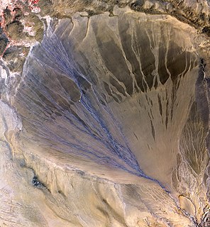
Alluvial fans are triangular-shaped deposits of water-transported material, often referred to as alluvium. They are an example of an unconsolidated sedimentary deposit and tend to be larger and more prominent in arid to semi-arid regions. These alluvial fans typically form in elevated or even mountainous regions where there is a rapid change in slope from a high to low gradient. The river or stream carrying the sediment flows at a relatively high velocity due to the high slope angle which is why coarse material is able to remain in the flow. When the slope decreases rapidly into a relatively plain or plateau, the stream loses the energy it needs to move its sediment. Deposition subsequently occurs and the sediment ultimately spreads out, creating an alluvial fan. Three primary zones occur within an alluvial fan which includes the proximal fan, medial fan, and the distal fan.

Several washes drain the southwest and the Muggins Mountains Wilderness including Long Mountain Wash, Twin Tanks Wash and Muggins Wash all drain southwest into the northeast Dome Valley foothills. Morgan Wash drains the southeast wilderness border to the southeast into Mohawk Valley. [2]

Vegetation

Ephemeral water sources only persist in winter-spring and should be considered nonexistent, except during rains, or winter, and standing water only lasts the longest in wetter and cooler years. The elevation of the mountains is such that there are no standing forests, only desert communities of vegetation. This section of the western Sonoran Desert, and local Yuma Desert is in the creosote bush scrub community. Desert ironwood, palo verde, catclaw acacia, saguaros, ocotillo, Anderson thornbush, smoketree, and creosote are some locally adapted tree/bush species. Brittlebush, saltbush, and bebbia are some common shrub forms.

Yuma Desert

The Yuma Desert is a lower-elevation section of the Sonoran Desert in the southwestern United States and the northwest of Mexico. It lies in the Salton basin. The desert contains areas of sparse vegetation and has notable areas of sand dunes. With an average rainfall less than 8 inches (200 mm) each year, this is among the harshest deserts in North America. Human presence is sparse throughout, the largest city being Yuma, Arizona, on the Colorado River and the border of California.

<i>Parkinsonia</i> genus of plants

Parkinsonia, also Cercidium, is a genus of flowering plants in the pea family, Fabaceae. It contains about 12 species that are native to semi-desert regions of Africa and the Americas. The name of the genus honors English apothecary and botanist John Parkinson (1567–1650).

Saguaro species of plant

The saguaro is an arborescent (tree-like) cactus species in the monotypic genus Carnegiea, which can grow to be over 40 feet (12 m) tall. It is native to the Sonoran Desert in Arizona, the Mexican State of Sonora, and the Whipple Mountains and Imperial County areas of California. The saguaro blossom is the state wildflower of Arizona. Its scientific name is given in honor of Andrew Carnegie. In 1994, Saguaro National Park, near Tucson, Arizona, was designated to help protect this species and its habitat.

The nearest communities to the Muggins Mountains are Dome, Ligurta, and Wellton in the Dome and Mohawk Valleys.

See also

Related Research Articles

Kofa Mountains

The Kofa Mountains of Yuma and La Paz counties in Arizona is the central mountain range of the Kofa National Wildlife Refuge. The range lies about 60 miles northeast of Yuma in the southwestern part of the state. The equally extensive Castle Dome Mountains comprise the southern refuge border; the western end of the Tank Mountains are in the southeast of the wildlife refuge, and the New Water Wilderness in the New Water Mountains ends the extension of the Kofa National Wildlife Refuge to the north. Scenic "King Valley" is south of the Kofa Mountains between the Castle Dome Mountains.

The Copper Mountains is a minor north-south trending mountain range, only 8 miles long in southwestern Arizona in the southwestern Sonoran Desert.

Muggins Mountain Wilderness

The Muggins Mountain Wilderness is a 7,711-acre (31.21 km2) wilderness area in the U.S. state of Arizona. It is located approximately 38 miles (61 km) east of Yuma, Arizona in the Muggins Mountains and adjacent to the agricultural Dome Valley and Gila River. The wilderness area is made up of the highest peak in the southern section of Muggins Mountains, Klothos Temple at 1,666 feet (508 m). Muggins Peak is adjacent to the peak southeastwards, at 1,424 feet (434 m). Three deeply cut washes drain the southwest border of the wilderness, Twin Tanks Wash, Muggins Wash, and Morgan Wash. Muggins Wash is the access point to the wilderness, by way of County 7th Street.

Tank Mountains

The Tank Mountains are a mountain range in the Sonoran Desert of southwest Arizona; the range is part of the southeastern border of the Kofa National Wildlife Refuge.

Cabeza Prieta Mountains mountain range

The Cabeza Prieta Mountains are a mountain range in the northwestern Sonoran Desert of southwest Arizona. It is located in southern Yuma County, Arizona.

The San Cristobal Valley is a valley in the lower regions of the western Gila River Valley in southwestern Arizona in the western Sonoran Desert. The San Cristobal Wash drains northwest, but exists only in the southern half of the valley.

Mohawk Mountains

The Mohawk Mountains is a mountain range in the northwest Sonoran Desert of southwest Arizona. It abuts the western Gila River valley to the north, and is located in southern Yuma County. The Mohawk Valley lies adjacent and southwest of the range; the San Cristobal Valley is northeast.

Gila Mountains (Yuma County)

The Gila Mountains of Yuma County are a 26-mile (42 km) long mountain range in southwestern Arizona in the northwest Sonoran Desert.

The San Cristobal Wash is an ephemeral wash and watercourse of the San Cristobal Valley, flowing north into the Gila River Valley of the southwestern desert region of Arizona. Besides Death Valley, the Chihuahuan Desert area, and regions of Baja Peninsula North America, the southeast California deserts along the Lower Colorado River Valley, this drainage region is in the harshest desert regions of North America.

Growler Mountains

The Growler Mountains is a 23-mile, (37-km) long north-south trending mountain range of far western Pima County, Arizona that lies 12 miles (19 km) west of Ajo, Arizona. This desert region of southern Arizona lies in the north and central Sonoran Desert, and is one of the drier desert areas of North America.

Altar Valley valley in southern Arizona

The Altar Valley is a 45-mile (72 km) long north-south valley, trending slightly northeast from Sasabe, Arizona on the Mexico border to the Avra Valley west of the Tucson Mountains. It is delimited by Arizona State Route 86, from east-to-west on the north separating it from the Avra Valley which then trends northwesterly, merging into the plains and drainage of the Santa Cruz River.

Laguna Mountains (Arizona)

The Laguna Mountains are a small, approximately circular mountain range of extreme southwest Arizona northeast of Yuma and east of Winterhaven, California on the Colorado River. The Colorado forms the western perimeter of the mountains; Mittry Lake, on the Colorado is on its northwest.

Granite Wash Mountains

The Granite Wash Mountains are a short, arid, low elevation mountain range of western-central Arizona, in the southeast of La Paz County. The range borders a slightly larger range southeast, the Little Harquahala Mountains; both ranges form a section on the same water divide between two desert washes. The washes flow in opposite directions, one northwest to the Colorado River, the other southeast to the Gila River.

Belmont Mountains

The Belmont Mountains are a 25 mi (40 km) long, arid, low elevation mountain range about 50 mi west of Phoenix, Arizona in the northern Sonoran Desert, north of the Gila River. The range is in the south of a region of two parallel washes; the Bouse Wash flows northwest to the Colorado River, and the Centennial Wash flows southeast to meet the Gila River.

Painted Rock Mountains

The Painted Rocks Mountains are a short 15-mile (24 km) long mountain range of the north-central Sonoran Desert southwest of Phoenix, Arizona and in southwest Maricopa County. The Gila River flows through the central-north end of the range.

References

  1. 1 2 3 4 5 Arizona Atlas & Gazetteer, DeLorme, 4th ed, 2001, p. 62 ISBN   0-89933-325-7
  2. 1 2 Yuma, Arizona - California - Baja California Norte, 30x60 Minute Topographic Map, USGS, 1993
  3. Dome, Arizona, 7.5 Minute Quadrangle, USGS, 1976

Coordinates: 32°44′42″N114°12′12″W / 32.7450461°N 114.2032728°W / 32.7450461; -114.2032728