Muhanga, Rukiga

Last updated

Muhanga
Uganda location map.svg
Red pog.svg
Muhanga
Location in Uganda
Coordinates: 01°10′16″S30°07′27″E / 1.17111°S 30.12417°E / -1.17111; 30.12417
Country Flag of Uganda.svg Uganda
Region Western Uganda
Sub-region Kigezi sub-region
District Rukiga District
Government
  MayorJames Twijukye [1]
Population
 (2014 Census)
  Total11,706 [2]

Muhanga is a town in the Western Region of Uganda. It is the main commercial centre and largest town of Rukiga District. However, the district headquarters are located at Mparo. [3]

Contents

Location

Muhanga is located on the Mbarara-Ntungamo-Kabale-Katuna Road, about 43 kilometres (27 mi), southwest of Ntungamo, the nearest large town on the road from Katuna to Mbarara. [4] This is about 35.5 kilometres (22 mi), by road, northeast of Kabale, the largest city in the Kigezi sub-region. [5] Muhanga is approximately 374 kilometres (232 mi), by road, southwest of Kampala, the largest city and capital of Uganda. [6] The geographical coordinates of Muhanga, Rukiga are: 01°10'16.0"S, 30°07'27.0"E (Latitude:-1.171111; Longitude:30.124167). [7]

Overview

The town is subdivided into several wards, including (a) Muhanga Central (b) Butare (c) Highland (d) Nyakabungo and (e) Rutare. [1] Muhanga became a town council in 2010. Prior to that, it was a trading center, established in the 1970s. Due to its proximity to the international border with Rwanda, smuggling of goods across the common border has contributed to its rapid growth. [1] The smuggling has since stopped, according to James Tumwijukye, the town's current mayor. [1]

Population

According to the Uganda Bureau of Statistics (UBOS), as of the August 2014 national census and household survey, Muhanga Town Council comprised 2,766 households. The average family size was 4.1, with a total of 5,87 males and 5,859 females in the town. The total population of the town at that time was 11,706 people. [2]

Points of interest

Muhanga has a central fresh produce market that opens daily. The town is also home to Bukinda Primary Teacher’s College, eight primary schools and six secondary schools. [1]

Related Research Articles

Fort Portal Place in Western Region, Uganda

Fort Portal is a designated "Tourism city of Uganda", located in the Western Region of the country. It is the seat of both Kabarole District and the Toro Kingdom.

Mbarara Place in Western Region, Uganda

Mbarara City is a city in the Western Region of Uganda. It is the main municipal, administrative, and commercial centre of Mbarara District and the site of the district headquarters.

Bushenyi Place in Western Uganda, Uganda

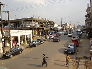
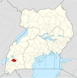
Bushenyi is a town in Western Uganda. It is the 'chief town' of Bushenyi District and the district headquarters are located there. The district is named after the town, in keeping with the practice in most of the districts in the country.

Ntungamo Place in Uganda

Ntungamo is a town in the Western Region of Uganda. It is the largest town in Ntungamo District and the site of the district headquarters. It is the hometown of longtime President Yoweri Museveni.

Kiruhura, Uganda Place in Uganda

Kiruhura is a town in the Western Region of Uganda. It is the largest town in Kiruhura District and the site of the district headquarters.

Lyantonde Place in Central Region of Uganda

Lyantonde is a town in the southern part of the Central Region of Uganda. It is the main municipal, administrative, and commercial center of Lyantonde District.

Ishaka Place in Uganda

Ishaka is a town in the Western Region of Uganda. It is one of the municipalities in Bushenyi District.

Buhweju District District in Uganda

Buhweju District is a district in Western Uganda. It is one of the districts that constitute the Ankole sub-region. Its 'chief town', is Nsiika.

Makenke Place in Uganda

Makenke is a neighborhood within Mbarara City, in the Western Region of Uganda.

Sanga, Uganda Place in Western Region, Uganda

Sanga, is an urban center in the Kiruhura District, Ankole sub-region, in the Western Region of Uganda.

Nyakahita Place in Western Region of Uganda

Nyakahita is a sparsely populated settlement in the Western Region of Uganda.

Kazo, Uganda Place in Western Region

Kazo is a town in the Western Region of Uganda.

Mbarara–Ntungamo–Kabale–Katuna Road is a road in the Western Uganda, connecting the city of Mbarara, in Mbarara District, with the towns of Ntungamo, Kabale and Katuna at the international border with the Republic of Rwanda.

Ntungamo–Rukungiri Road is in the Western Region of Uganda, connecting the towns of Ntungamo in Ntungamo District with Rukungiri in Rukungiri District.

Rubanda District is a district in the Western Region of Uganda. The largest town in the district, Rubanda, serves as the main administrative and commercial center in the district.

Rubanda Place in Western Uganda, Uganda

Rubanda is a town in the extreme southwest of the Western Region of Uganda. It serves as the commercial, political and administrative center of Rubanda District.

Rukiga District is a district in Western Uganda. Its capital is Mparo. However, the largest urban center in the district is Muhanga.

Mparo, Rukiga Place in Western Uganda, Uganda

Mparo is a town in the Western Region of Uganda. It is the political and administrative center of Rukiga District. However, the largest town in the district and its major commercial center is Muhanga.

Rubona, Bunyangabu Place in Western Uganda, Uganda

Rubona is a town in the Western Region of Uganda.

References

  1. 1 2 3 4 5 Muhereza, Robert (1 August 2018). "Muhanga, from smuggling centre to fast growing town". Daily Monitor . Kampala. Retrieved 1 August 2018.
  2. 1 2 UBOS (November 2014). "National Population and Housing Census 2014: Provisional Results: Appendix 3 - Households and Population by Subcounty/ Town Council/Urban Division and Sex, 2014" (PDF). Kampala: Uganda Bureau of Statistics (UBOS). Archived from the original (PDF) on 10 January 2017. Retrieved 11 August 2017.
  3. Mulera, Muniini (1 July 2017). "Overview of Rukiga District, Uganda". Toronto: Mulerasfireplace.com. Retrieved 11 August 2017.
  4. GFC (11 August 2017). "Distance between Ntungamo, Western Region, Uganda and Muhanga, Rukiga, Western Region, Uganda". Globefeed.com (GFC). Retrieved 11 August 2017.
  5. GFC (11 August 2017). "Distance between Kabale, Western Region, Uganda and Muhanga, Rukiga, Western Region, Uganda". Globefeed.com (GFC). Retrieved 11 August 2017.
  6. GFC (11 August 2017). "Distance between Post Office Building, Kampala Road, Kampala, Uganda and Muhanga, Rukiga, Western Region, Uganda". Globefeed.com (GFC). Retrieved 11 August 2017.
  7. Google (11 August 2017). "Location of Muhanga, Rukiga District, Western Region, Uganda" (Map). Google Maps . Google. Retrieved 11 August 2017.

Coordinates: 01°10′16″N30°07′27″E / 1.17111°N 30.12417°E / 1.17111; 30.12417