
U.S. Route 101, or U.S. Highway 101 (US 101), is a north–south United States Numbered Highway that runs through the states of California, Oregon, and Washington, on the West Coast of the United States. It is also known as El Camino Real where its route along the southern and central California coast approximates the commemorative trail which links the Spanish missions, pueblos, and presidios. It merges at some points with California State Route 1 (SR 1).

State Route 1 (SR 1) is a major north–south state highway that runs along most of the Pacific coastline of the U.S. state of California. At 656 miles (1,056 km), it is the longest state route in California, and the second-longest in the US after Montana Highway 200. SR 1 has several portions designated as either Pacific Coast Highway (PCH), Cabrillo Highway, Shoreline Highway, or Coast Highway. Its southern terminus is at Interstate 5 (I-5) near Dana Point in Orange County and its northern terminus is at U.S. Route 101 (US 101) near Leggett in Mendocino County. SR 1 also at times runs concurrently with US 101, most notably through a 54-mile (87 km) stretch in Ventura and Santa Barbara counties, and across the Golden Gate Bridge.
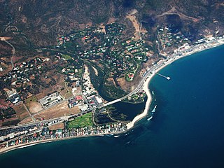
Malibu is a beach city in the Santa Monica Mountains region of Los Angeles County, California, about 30 miles (48 km) west of Downtown Los Angeles. It is known for its Mediterranean climate, its strip of beaches stretching 21 miles along the Pacific Ocean coast, and for its longtime status as the home of numerous affluent Hollywood celebrities and executives. Although a high proportion of its residents are entertainment industry figures with million-dollar mansions, Malibu also features several middle- and upper-middle-class neighborhoods. The Pacific Coast Highway traverses the city and has led most residents to settle anywhere from half a mile to within a few hundred yards of it, with some residents living up to one mile away from the beach in areas featuring narrow canyons. As of the 2020 census, the city's population was 10,654.
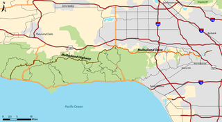
Mulholland Drive is a street and road in the eastern Santa Monica Mountains of Southern California. It is named after pioneering Los Angeles civil engineer William Mulholland. The western rural portion in Los Angeles and Ventura Counties is named Mulholland Highway. The road is featured in a significant number of films, songs, and novels. David Lynch, who wrote and directed a film named after Mulholland Drive, has said that one can feel "the history of Hollywood" on it. Jack Nicholson has lived on Mulholland Drive for many years, and still lives there today.

The Santa Monica Mountains is a coastal mountain range in Southern California, next to the Pacific Ocean. It is part of the Transverse Ranges. The Santa Monica Mountains National Recreation Area encompasses this mountain range. Because of its proximity to densely populated regions, it is one of the most visited natural areas in California.

The Ventura Freeway is a freeway in southern California, United States, running from the Santa Barbara/Ventura county line to Pasadena in Los Angeles County. It is the principal east-west route through Ventura County and in the southern San Fernando Valley in Los Angeles County. From the Santa Barbara County line to its intersection with the Hollywood Freeway in the southeastern San Fernando Valley in Los Angeles, it is signed as U.S. Route 101 (US 101), which was built in the late 1950s and opened on April 5, 1960. East of the Hollywood Freeway intersection, it is signed as State Route 134 (SR 134) which was built by 1971.
The Santa Monica Mountains Conservancy is an agency of the state of California in the United States founded in 1980 and dedicated to the acquisition of land for preservation as open space, for wildlife and California native plants habitat Nature Preserves, and for public recreation activities.
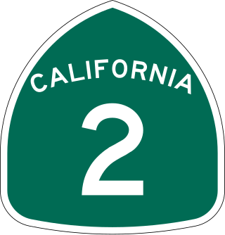
State Route 2 (SR 2) is a state highway in the U.S. state of California. It connects the Los Angeles Basin with the San Gabriel Mountains and the Victor Valley in the Mojave Desert. The highway's southwestern end is at the intersection of Centinela Avenue at the Santa Monica-Los Angeles border and its northeastern end is at SR 138 east of Wrightwood. The SR 2 is divided into four segments, and it briefly runs concurrently with U.S. Route 101 (US 101) and Interstate 210 (I-210). The southwestern section of SR 2 runs along a segment of the east–west Santa Monica Boulevard, an old routing of US 66, to US 101 in East Hollywood; the second section runs along segments of both the north–south Alvarado Street and Glendale Boulevard in Echo Park; the third section to I-210 in Glendale is known as the north–south Glendale Freeway; and the northeastern portion from I-210 in La Cañada Flintridge to SR 138 is designated as the Angeles Crest Highway.
The State Scenic Highway System in the U.S. state of California is a list of highways, mainly state highways, that have been designated by the California Department of Transportation (Caltrans) as scenic highways. They are marked by the state flower, a California poppy, inside either a rectangle for state-maintained highways or a pentagon for county highways.

State Route 118 is a state highway in the U.S. state of California that runs west to east through Ventura and Los Angeles counties. It travels from State Route 126 at the eastern edge of Ventura immediately northwest of Saticoy, then through Saticoy, in Ventura County east to Interstate 210 near Lake View Terrace in Los Angeles. SR 118 crosses the Santa Susana Pass and the northern rim of the San Fernando Valley along its route.

State Route 23 is a state highway in the U.S. state of California that connects the Pacific coast and the Santa Monica Mountains to the Conejo and Santa Clara River valleys. It runs from Pacific Coast Highway in Malibu in Los Angeles County to Ventura Street in Fillmore in Ventura County.

The Southern California freeways are a vast network of interconnected freeways in the megaregion of Southern California, serving a population of 23 million people. The Master Plan of Metropolitan Los Angeles Freeways was adopted by the Regional Planning Commission in 1947 and construction began in the early 1950s. The plan hit opposition and funding limitations in the 1970s, and by 2004, only some 61% of the original planned network had been completed.

Leo Carrillo State Park is a state park in Los Angeles County, California, United States. Situated along the Malibu coast, the park is a component of Santa Monica Mountains National Recreation Area. With 1.5 miles (2.4 km) of beach, the parkland stretches into the Santa Monica Mountains. The park has expanded into Ventura County and also includes management of County Line Beach. California State Route 1 runs through the park, where it intersects with the western terminus of the Mulholland Highway. The 2,513-acre (1,017 ha) park was established in 1953. It is named for actor and conservationist Leo Carrillo (1880–1961), who served on the State Parks commission.

The Santa Monica Mountains National Recreation Area is a United States national recreation area containing many individual parks and open space preserves, located primarily in the Santa Monica Mountains of Southern California. The SMMNRA is in the greater Los Angeles region, with two thirds of the parklands in northwest Los Angeles County, and the remaining third, including a Simi Hills extension, in southeastern Ventura County.
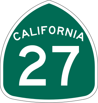
State Route 27, commonly known by its street name Topanga Canyon Boulevard, is a state highway in the U.S. state of California that runs from the Pacific Coast Highway at Topanga State Beach near Pacific Palisades, through the Topanga Canyon in Topanga, and continuing through Woodland Hills, Canoga Park, West Hills, and Chatsworth to the Ronald Reagan Freeway.
U.S. Route 101 (US 101) is a major north–south United States Numbered Highway, stretching from Los Angeles, California, to Tumwater, Washington. The California portion of US 101 is one of the last remaining and longest U.S. Routes still active in the state, and the longest highway of any kind in California. US 101 was also one of the original national routes established in 1926. Significant portions of US 101 between the Los Angeles area and the San Francisco Bay Area follow El Camino Real, the commemorative route connecting the former Alta California's 21 missions.

The Backbone Trail is a long-distance trail extending 67.79 miles (109.10 km) across the length of the Santa Monica Mountains in the U.S. state of California. Its western terminus is Point Mugu State Park, and its eastern terminus is Will Rogers State Historic Park in Pacific Palisades. The trail is open to hikers throughout its length. Dogs, mountain bicyclists and horseback riders are only allowed on portions of the trail as posted.
Cornell is an unincorporated community in the Santa Monica Mountains, within western Los Angeles County, California. It is located 5 miles (8.0 km) west of Agoura Hills and around 2.5 miles (4.0 km) north of Malibu.
There are 9 routes assigned to the "N" zone of the California Route Marker Program, which designates county routes in California. The "N" zone includes county highways lying in Los Angeles and Orange counties.
County Line Beach is beach park located in Solromar, an unincorporated community of Ventura County. This stretch of sandy beach is easily accessible from the adjacent Pacific Coast Highway. This popular surf spot is administered as part of Leo Carrillo State Park. The beach lies within the south coast portion of the Ventura County amidst a mostly rugged coastline that is some of the most striking and diverse coastal terrain in the County. The beach lies at the mouth of a canyon in the Santa Monica Mountains that hug the shore along the Ventura County's south coast.


