Municipal Borough of Glossop

Last updated
Glossop
Municipal Borough of Glossop, Derbyshire (1970).svg
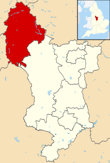
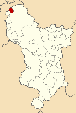
Municipal Borough of Glossop shown within Derbyshire in 1970.
Area
  19113,052 acres (12.35 km2)
  19613,323 acres (13.45 km2)
Population
  191121,688
  196117,500
History
  Created1866
  Abolished1974
  Succeeded by High Peak
Status Municipal Borough
GovernmentGlossop Borough Council
   HQ Glossop

Glossop was a Municipal Borough in Derbyshire, England from 1866 to 1974. [1] It was created under the Municipal Corporations Act 1835.

Derbyshire ceremonial county in East Midlands, England

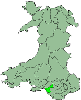
Derbyshire is a county in the East Midlands of England. A substantial portion of the Peak District National Park lies within Derbyshire, containing the southern extremity of the Pennine range of hills which extend into the north of the county. The county contains part of the National Forest, and borders on Greater Manchester to the northwest, West Yorkshire to the north, South Yorkshire to the northeast, Nottinghamshire to the east, Leicestershire to the southeast, Staffordshire to the west and southwest and Cheshire also to the west. Kinder Scout, at 636 metres (2,087 ft), is the highest point in the county, whilst Trent Meadows, where the River Trent leaves Derbyshire, is its lowest point at 27 metres (89 ft). The River Derwent is the county's longest river at 66 miles (106 km), and runs roughly north to south through the county. In 2003 the Ordnance Survey placed Church Flatts Farm at Coton in the Elms as the furthest point from the sea in Great Britain.

England Country in north-west Europe, part of the United Kingdom

England is a country that is part of the United Kingdom. It shares land borders with Wales to the west and Scotland to the north-northwest. The Irish Sea lies west of England and the Celtic Sea lies to the southwest. England is separated from continental Europe by the North Sea to the east and the English Channel to the south. The country covers five-eighths of the island of Great Britain, which lies in the North Atlantic, and includes over 100 smaller islands, such as the Isles of Scilly and the Isle of Wight.

Municipal Corporations Act 1835 Act of the Parliament of the United Kingdom

The Municipal Corporations Act 1835, sometimes known as the Municipal Reform Act, was an Act of the Parliament of the United Kingdom that reformed local government in the incorporated boroughs of England and Wales. The legislation was part of the reform programme of the Whigs and followed the Reform Act 1832, which had abolished most of the rotten boroughs for parliamentary purposes.

It was enlarged in 1934 when part of the civil parish of Charlesworth was incorporated into the borough. [2]

Charlesworth, Derbyshire Village and civil parish in High Peak, Derbyshire

Charlesworth is a village and civil parish near Glossop, Derbyshire, England. The population of the civil parish at the 2011 Census was 2,449. It is 2 miles (3.2 km) south-west of Glossop town centre and close to the borders of Greater Manchester with the nearby village of Broadbottom in Tameside. The parish church of St John the Baptist was built in 1848–49. The Congregational Chapel was rebuilt from an earlier chapel in 1797. Broadbottom Bridge, one end of which is in Cheshire, was built in 1683. Charlesworth holds an annual carnival on the second Saturday in July on its recreation ground on Marple Road, which includes fell races and other events.

The borough was abolished in 1974 under the Local Government Act 1972 and combined with the Municipal Borough of Buxton, the urban districts of New Mills and Whaley Bridge and the rural districts of Chapel en le Frith and Tintwistle to form the new High Peak district. [3]

Local Government Act 1972 Act of Parliament in the United Kingdom

The Local Government Act 1972 is an Act of the Parliament of the United Kingdom that reformed local government in England and Wales on 1 April 1974.

Municipal Borough of Buxton

Buxton was an Urban District from 1894 to 1917 and a Municipal Borough from 1917 to 1974 in Derbyshire, England.

New Mills was an Urban District in Derbyshire, England from 1894 to 1974. It was created under the Local Government Act 1894.

Related Research Articles

High Peak, Derbyshire Place in England

High Peak is a borough in Derbyshire, England. Administered by High Peak Borough Council from Buxton and Glossop, it is mostly composed of high moorland plateau in the Dark Peak area of the Peak District National Park. The district stretches from Holme Moss in the north to Sterndale Moor in the south and from Hague Bar in the west to Bamford in the east. The population of the borough taken at the 2011 Census was 90,892.

Kennet was a non-metropolitan local government district in Wiltshire, England, abolished as part of the 2009 structural changes to local government in England. It was named after the River Kennet.

East Yorkshire (district) district

The Borough of East Yorkshire was one of nine local government districts of the county of Humberside, England from 1 April 1974 to 1 April 1996.

Glanford

Glanford was, from 1974 to 1996, a local government district with borough status in the non-metropolitan county of Humberside, England.

Salisbury was a local government district in Wiltshire, England from 1974 to 2009. Its main urban area was the city of Salisbury.

Colwyn district in Wales

The Borough of Colwyn was one of six districts of the county of Clwyd, north-east Wales, from 1974 to 1996.

District of Delyn

Delyn is an area in north Wales. From 1974 to 1996 it was a district of Clwyd, but is now included in the county of Flintshire. Delyn is twinned with Menden, Germany.

Tintwistle Rural District was a local government district in north east Cheshire, England from 1894 to 1974.

Spenborough was, from 1915 to 1974, a local government district in the administrative county of Yorkshire, West Riding, England.

District of Port Talbot

Port Talbot was one of the four local government districts of the county of West Glamorgan, Wales from 1974 to 1996.

Bucklow Rural District was, from 1894 to 1974, a local government district in the north of the administrative county of Cheshire, England. Following the Local Government Act 1972, this rural district was split between the new Greater Manchester boroughs of Trafford and Manchester, and Macclesfield, which was retained in Cheshire.

Wirral was an urban district in Cheshire, England from 1933 to 1974. It was created from part of the disbanded Wirral Rural District and covered an area in the south-west of the Wirral Peninsula. The district covered the areas of Barnston, Gayton, Heswall cum Oldfield, Irby, Pensby, and Thurstaston.

East Retford Rural District

East Retford was a rural district in Nottinghamshire, England from 1894 to 1974.

County Borough of Preston

Preston Municipal Borough, also known as the County Borough of Preston from 1889, was a local government district coterminate with the town of Preston in Lancashire, northwest England from 1836 to 1974.

Aylesbury was, from 1894 to 1974, a local government district in Buckinghamshire, England. It was incorporated as a municipal borough in 1917.

Municipal Borough of Chesterfield

Chesterfield was a Municipal Borough in Derbyshire, England from 1835 to 1974. It was formed under the Municipal Corporations Act 1835 from the Ancient borough of Chesterfield.

Ilkeston was a Municipal Borough in Derbyshire, England from 1887 to 1974. It was formed under the Municipal Corporations Act 1882.

Long Eaton was an Urban District in Derbyshire, England from 1894 to 1974. It was created under the Local Government Act 1894.

References

  1. F A Youngs Jr., Guide to the Local Administrative Units of England, Vol II: Northern England, London, 1991
  2. Great Britain Historical GIS / University of Portsmouth, Glossop Municipal Borough . Retrieved 2016-03-10.
  3. The English Non-metropolitan Districts (Definition) Order 1972 (SI 1972/2039)

Coordinates: 53°26′35″N1°56′56″W / 53.443°N 1.949°W / 53.443; -1.949

Geographic coordinate system Coordinate system

A geographic coordinate system is a coordinate system that enables every location on Earth to be specified by a set of numbers, letters or symbols. The coordinates are often chosen such that one of the numbers represents a vertical position and two or three of the numbers represent a horizontal position; alternatively, a geographic position may be expressed in a combined three-dimensional Cartesian vector. A common choice of coordinates is latitude, longitude and elevation. To specify a location on a plane requires a map projection.