Municipal Borough of Swinton and Pendlebury

Last updated
Swinton and Pendlebury
Swinton Town Hall.jpg Swinton and Pendlebury Town Hall
Area
  1901 2,284 acres (9.24 km²)
  1971 3,362 acres (13.69 km²)
Population
  1901 27,005
  1971 40,166
History
  Created 1894
  Abolished 1974
  Succeeded by City of Salford
Status Urban district (1894-1934)
Municipal borough
and civil parish (after 1934)
   HQ Swinton
Swinton and Pendlebury Council - coat of arms.PNG

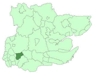
Swinton and Pendlebury was a local government district of the administrative county of Lancashire, England. It was created in 1894 as an urban district and enlarged in 1934, gaining the status of a municipal borough.

Administrative counties of England Former subnational divisions of England

Administrative counties were a level of subnational division of England used for the purposes of local government from 1889 to 1974. They were created by the Local Government Act 1888 as the areas for which county councils were elected. Some large counties were divided into several administrative counties, each with its own county council. The administrative counties were abolished by the Local Government Act 1972 and were replaced by the metropolitan and non-metropolitan counties of England.

Lancashire County of England

Lancashire is a ceremonial county in North West England. The administrative centre is Preston. The county has a population of 1,449,300 and an area of 1,189 square miles (3,080 km2). People from Lancashire are known as Lancastrians.

In England and Wales, Northern Ireland, and the Republic of Ireland, an urban district was a type of local government district that covered an urbanised area. Urban districts had an elected urban district council (UDC), which shared local government responsibilities with a county council.

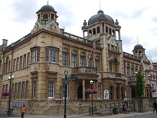
Before the new town hall was built to accommodate the new municipal borough in the 1930s, the urban district was governed from Pendlebury Town Hall on Bolton Road at the junction with Carrington Street. This building eventually became the town's main public library and was used as such until a new library was opened within the newly built Lancastrian Hall on Chorley Road, Swinton at the junction with Station Road (B5231).

Pendlebury town in the City of Salford, in Greater Manchester, England

Pendlebury is a suburban town in the City of Salford, Greater Manchester, England. The population at the 2011 Census was 13,069. It lies 4.1 miles (6.6 km) northwest of Manchester city centre, 3.4 miles (5.5 km) northwest of Salford, and 5.9 miles (9.5 km) southeast of Bolton.

A666 road road in England

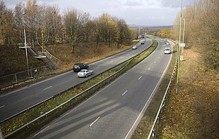
The A666 is a major road in Greater Manchester and Lancashire, England. Known as Manchester Road, Bolton Road, or Blackburn Road, depending on which area it is in, it runs from its junction with the A6, M61 and A580 at the Irlams o' th' Height boundary with Pendlebury near Manchester, through Pendlebury, Clifton, Kearsley, Farnworth, Bolton, Darwen and Blackburn before meeting the A59 at Langho. Along the route are the West Pennine Moors, the Turton and Entwistle reservoir and the Entwistle reservoir forest.

A6 road (England) north-south road in England

The A6 is one of the main historic north–south roads in England. It currently runs from Luton in Bedfordshire to Carlisle in Cumbria, although it formerly started at a junction with the A1 at Barnet. It is the fourth longest numbered road in Britain, behind only the A1, A38 and A30.

Constituent civil parishes

It was created as an urban district in 1894 by the Local Government Act 1894, consisting of the civil parishes of Swinton and Pendlebury. When Barton-upon-Irwell Rural District was abolished in 1933 Swinton and Pendlebury gained part of the Clifton parish (an area of 1,052 acres (4.26 km2)). [1] In 1934 Swinton parish and Pendlebury parish were abolished and their former area was merged with that of the former Clifton parish to form a combined Swinton and Pendlebury parish which was coterminous with the urban district boundaries. [2]

Local Government Act 1894

The Local Government Act 1894 was an Act of the Parliament of the United Kingdom that reformed local government in England and Wales outside the County of London. The Act followed the reforms carried out at county level under the Local Government Act 1888. The 1894 legislation introduced elected councils at district and parish level.

Swinton, Greater Manchester town within the City of Salford, in Greater Manchester, England

Swinton is a town in Greater Manchester, England, southwest of the River Irwell, 3.4 miles (5.5 km) northwest of Salford and 4.2 miles (6.8 km) northwest of Manchester, adjoining the towns of Pendlebury and Clifton. In 2014, it had a population of 22,931.

Barton-upon-Irwell was, from 1894 to 1933, a rural district in the administrative county of Lancashire, England.

The municipal borough was abolished in 1974 by the Local Government Act 1972. Its former area was used to form part of the present-day City of Salford metropolitan borough in the Greater Manchester metropolitan county. Swinton and Pendlebury Town Hall is currently used by Salford City Council as the Salford Civic Centre . [3]

Local Government Act 1972 Act of Parliament in the United Kingdom

The Local Government Act 1972 is an Act of the Parliament of the United Kingdom that reformed local government in England and Wales on 1 April 1974.

City of Salford Metropolitan borough and city in England

The City of Salford, commonly known as Salford, is a city and metropolitan borough of Greater Manchester, England, extending west to include the towns of Eccles, Worsley, Swinton, Walkden, Little Hulton, and Irlam. The city has a population of 245,600, and is administered from the Salford Civic Centre in Swinton.

Metropolitan borough type of local government district in England

A metropolitan borough is a type of local government district in England, and is a subdivision of a metropolitan county. Created in 1974 by the Local Government Act 1972, metropolitan boroughs are defined in English law as metropolitan districts. However, all of them have been granted or regranted royal charters to give them borough status. Metropolitan boroughs have been effectively unitary authority areas since the abolition of the metropolitan county councils by the Local Government Act 1985. However, metropolitan boroughs pool much of their authority in joint boards and other arrangements that cover whole metropolitan counties, such as combined authorities.

Related Research Articles

Metropolitan Borough of Wigan Metropolitan borough in England

The Metropolitan Borough of Wigan is a metropolitan borough of Greater Manchester, in North West England. It is named after its largest component town and former county borough, Wigan and includes the towns and villages of Leigh, part of Ashton-in-Makerfield, Ince-in-Makerfield, Hindley, Orrell, Standish, Atherton, Tyldesley, Golborne, Lowton, Billinge, Astley, Haigh and Aspull. The borough was formed in 1974 and is an amalgamation of several former local government districts and parishes. The borough has three civil parishes and lies directly to the west of the City of Salford and southwest of the Metropolitan Borough of Bolton. The local authority is Wigan Metropolitan Borough Council.

Clifton, Greater Manchester human settlement in United Kingdom

Clifton is a small town within the City of Salford, Greater Manchester, England. Historically in Lancashire, it lies alongside and in the Irwell Valley in the northern part of the City of Salford. Clifton, a former centre for coal mining, once formed part of the Municipal Borough of Swinton and Pendlebury.

Municipal Borough of Romford

Romford was a local government district in southwest Essex from 1851 to 1965. It was significantly expanded in 1934 and gained the status of municipal borough in 1937. The population density of the district consistently increased during its existence and its former area now corresponds to the northern part of the London Borough of Havering in Greater London.

Municipal Borough of Beckenham

Beckenham was a local government district in north west Kent from 1878 to 1965 around the town of Beckenham. The area was suburban to London, formed part of the Metropolitan Police District and from 1933 was included in the area of the London Passenger Transport Board.

Municipal Borough of Southgate

Southgate was a local government district of Middlesex from 1881 to 1965. It was part of the London postal district and Metropolitan Police District.

Municipal Borough of Ilford

Ilford was a civil parish and local government district in south west Essex, England from 1888 to 1965, covering the town Ilford. The district saw a considerable rise in population throughout its life, caused by the expansion of the built-up area of London, and became one of the most populous districts of its type in England. The district now corresponds to the greater part of the London Borough of Redbridge in Greater London.

Municipal Borough of Twickenham

Twickenham was a local government district in Middlesex, England from 1868 to 1965.

Municipal Borough of Wanstead and Woodford

Wanstead and Woodford was a local government district from 1934 to 1965 in southwest Essex, England. A merger of two former urban districts, it was suburban to London and part of the Metropolitan Police District.

Irlams o' th' Height is an area of Salford, Greater Manchester, England, on the extremity of the pre-1974 Salford city boundary, next to Swinton and Pendlebury.

Denton Urban District was a local government district in England from 1894 to 1974.

The County Borough of Wigan was, from 1889 to 1974, a local government district centred on Wigan in the northwest of England. It was alternatively known as Wigan County Borough.

Municipal Borough of Leigh

The Municipal Borough of Leigh was, from 1899 to 1974, a local government district of the administrative county of Lancashire, England, consisting of the townships of Pennington, Westleigh, Bedford and part of the township of Atherton and named after the ancient ecclesiastcal parish. The area contained the market town of Leigh that served as its administrative centre until its dissolution in 1974. The borough council built Leigh Town Hall which was completed in 1907.

Royton Urban District

Royton was, from 1863 to 1974, a local government district in Lancashire, England which covered the modern-day town of Royton, and its suburbs and districts.

Chelmsford Rural District was a local government district in Essex, England from 1894 to 1974. It surrounded, but did not include, the town of Chelmsford; which formed a municipal borough.

Municipal Borough of Farnworth

The Municipal Borough of Farnworth was a local government district centred on the town of Farnworth in the administrative county of Greater Manchester, England. A local board of health had been established for Farnworth in 1863, which was reconstituted as an urban district in 1899, before being granted a charter of incorporation to become a municipal borough in 1939. Following abolition of the local authority in 1974, Farnworth became an unparished area of the Metropolitan Borough of Bolton in Greater Manchester.

Kearsley was, from 1865 to 1974, a local government district centred on the town of Kearsley in the administrative county of Lancashire, England.

Chorley Rural District was a rural district in the administrative county of Lancashire, England from 1894 to 1974.

References

  1. Vision of Britain Archived 2007-10-01 at the Wayback Machine . - Swinton and Pendlebury UD/MB history
  2. Vision of Britain Archived 2007-09-30 at the Wayback Machine . - Boundaries of Swinton and Pendlebury parish
  3. Salford City Council - How to find our main council offices

Coordinates: 53°31′N2°19′W / 53.51°N 2.32°W / 53.51; -2.32

Geographic coordinate system Coordinate system

A geographic coordinate system is a coordinate system that enables every location on Earth to be specified by a set of numbers, letters or symbols. The coordinates are often chosen such that one of the numbers represents a vertical position and two or three of the numbers represent a horizontal position; alternatively, a geographic position may be expressed in a combined three-dimensional Cartesian vector. A common choice of coordinates is latitude, longitude and elevation. To specify a location on a plane requires a map projection.