Clifton, Greater Manchester

Last updated

Clifton
Terraces, Rake Lane.jpg
Housing on Rake Lane near the railway station
Greater Manchester UK location map 2.svg
Red pog.svg
Clifton
Location within Greater Manchester
OS grid reference SD775035
Metropolitan borough
Metropolitan county
Region
Country England
Sovereign state United Kingdom
Post town MANCHESTER
Postcode district M27
Dialling code 0161
Police Greater Manchester
Fire Greater Manchester
Ambulance North West
UK Parliament
List of places
UK
England
Greater Manchester
53°31′26″N2°19′13″W / 53.5239°N 2.3203°W / 53.5239; -2.3203

Clifton is a suburb of Swinton in the City of Salford in Greater Manchester, England. It lies along the edge of Irwell Valley in the north of the City of Salford. Historically in Lancashire, it was a centre for coal mining, and once formed part of the Municipal Borough of Swinton and Pendlebury.

Contents

History

Clifton is derived from the Old English clif and tun, and means the "settlement near a cliff, slope or riverbank". [1] Clifton was mentioned in the Pipe Roll of 1183–84. [2]

Coal mining

Clifton Hall Colliery was west of Lumns Lane, on the site now occupied by a domestic refuse and recycling site run by the Greater Manchester Waste Disposal Authority. The colliery was operating by 1820, and its tramway is shown on a parliamentary plan from 1830 and an 1845 map. It closed in 1929.

On 18 June 1885, an underground explosion at the colliery killed 178 men and boys. [3] The inquest and the official report concluded that explosion was caused by firedamp igniting on contact with a candle. [4] Blacksmith George Hindley (aged 16) and fireman George Higson, were part of a band of men who descended into the mine immediately after the explosion. They received an Albert Medal (2nd class) in recognition of their heroism.

Wet Earth Colliery in Clifton closed in 1928; its remains can still be seen in Clifton Country Park, close to the River Irwell and the Manchester-Preston railway line near the bottom of Clifton House Road, which runs uphill from the Irwell Valley to its junction with the A666 Manchester Road, opposite Clifton Cricket Ground.

Industry

The Pilkington's Lancastrian Pottery was established in 1892. The Chloride Electrical Storage Company opened its battery factory at Clifton Junction in 1893. Magnesium Elektron Ltd built a large factory at Clifton Junction to produce magnesium metal in 1936.

Governance

Clifton was a township in the ecclesiastical parish of Eccles in the hundred of Salford in Lancashire. [5] The township was dissolved in 1933 and its areas divided between Kearsley Urban District and the Municipal Borough of Swinton and Pendlebury. [6]

Geography

Clifton lies five miles north west of Manchester on the A666 road (Manchester Road) to Bolton. The township covered 850 acres in the valley of the River Irwell, which forms the north east boundary. The Manchester-Preston railway line passes through and there was a junction with the line to Bury and Rossendale which opened to Rawtenstall in September 1846. The highest land rises to over 300 feet above sea level in the west of the township near the Worsley boundary and is moss land. The underlying rocks are New Red Sandstone between Clifton and Ringley while the rest of the township lies on the Middle Coal Measures of the Manchester Coalfield. [2] Much of Clifton's boundary with Pendlebury is defined by Slack Brook which flows eventually into the Irwell not far from where Agecroft Power Station once stood. Slack Brook has been largely culverted for many years under landfill tipping since the 1950s.

Transport

Clifton is served by Clifton railway station on the Ribble Valley Line. In earlier times, the station was known as "Clifton Junction" from its location at the junction of the Manchester and Bolton Railway and Manchester, Bury and Rossendale Railway lines. The Bury line left the station/junction and passed over Clifton Viaduct, known locally as "the thirteen arches", [7] [8] across the Irwell Valley. Clifton Junction was important in bringing workers to the three large factories in the area, Magnesium Elektron Ltd (M.E.L.), Chloride Batteries and Pilkington's Tiles. The Manchester, Bolton and Bury Canal passed through Clifton. The Clifton Aqueduct carried the canal across the River Irwell. [9] and is preserved as a Grade II listed building. [8] There are plans to restore the canal for leisure use at a cost of over £50M.

Clifton railway station. Clifton Station - geograph.org.uk - 1775747.jpg
Clifton railway station.

Churches

The area is served by two Anglican churches. St. Anne's has stood on Manchester Road since its completion in 1874. St. Thomas's on Delamere Avenue, off Rake Lane, was built in 1974 to replace an earlier building on Rake Lane opposite the junction with Whitehead Road. The earlier church was built in 1898 as a mission church to serve a small community of outlying farms and cottages. Composed of corrugated metal sheeting, it became known affectionately as “Th'owd Tin Mission” rather than St. Thomas's.

Education

Clifton has two primary schools and a pupil referral unit within its boundaries:

SchoolLocalityDescriptionOfsted
Clifton Primary SchoolWroe Street, Clifton, M27 6PF Primary school 105907
St Mark's R.C. Primary SchoolQueensway, Clifton, M27 8QEPrimary school 105956
The Clifton CentreSilverdale, Clifton, M27 8GW Pupil referral unit 130007

Clifton Library

Clifton Library is located on Wynne Avenue (formerly part of Rake Lane) in the Clifton Community Centre.

Sport

Clifton Cricket Club play in the Premier Division of the recently established Greater Manchester Cricket League. The Club have gone through a recent period of success with winning the GMCLT20 competition 3 times and becoming regional T20 champions. They also reached the finals of both the National ECB Club Vitality Blast and the Lancashire Knock Out. The club's ground is on Manchester Road not far from junction 16 of the M60 motorway.

Queensmere Dam off Queensway is leased from the Forestry Commission by Swinton and Pendlebury Anglers. Queensway was only built (across what was farmland) in the early 1960s to directly link much of Rake Lane and Lumns Lane (at the former Bee Hive public house - now Holyrood private nursery) with Bolton Road (A666), Pendlebury at its junction with Station Road (B5231) instead of having to use nearby Billy Lane. Before this, Queensmere Dam was known locally as simply "the Dam".

Public houses

There are currently three public houses within Clifton. These are the Oddfellows Arms, the Golden Lion and the Robin Hood, all along the same side of Manchester Road. On Rake Lane, at the junction with Queensway, stands the Holyrood nursery which was, until recent times, the Beehive public house.

Clifton Barracks

The British Army's Territorial Army Centre on Manchester Road, very close to junction 16 of the M60 motorway, is known locally by its informal title of "Clifton Barracks".

See also

Related Research Articles

<span class="mw-page-title-main">Manchester Bolton & Bury Canal</span> Canal in Greater Manchester, England

The Manchester Bolton & Bury Canal is a disused canal in Greater Manchester, England, built to link Bolton and Bury with Manchester. The canal, when fully opened, was 15 miles 1 furlong (24 km) long. It was accessed via a junction with the River Irwell in Salford. Seventeen locks were required to climb to the summit as it passed through Pendleton, heading northwest to Prestolee before it split northwest to Bolton and northeast to Bury. Between Bolton and Bury the canal was level and required no locks. Six aqueducts were built to allow the canal to cross the rivers Irwell and Tonge and several minor roads.

<span class="mw-page-title-main">Worsley</span> Village in Greater Manchester, England

Worsley is a village in the City of Salford, Greater Manchester, England, which in 2014 had a population of 10,090. It lies along Worsley Brook, 6 miles (9.7 km) west of Manchester.

<span class="mw-page-title-main">Pendlebury</span> Town in Greater Manchester, England

Pendlebury is a town in the City of Salford, Greater Manchester, England. The population at the 2011 Census was 13,069. It lies 4 miles (6 km) north-west of Manchester, 3 miles (5 km) north-west of Salford and 6 miles (10 km) south-east of Bolton.

<span class="mw-page-title-main">Swinton, Greater Manchester</span> Town in Greater Manchester, England

Swinton is a town in the City of Salford in Greater Manchester, England. southwest of the River Irwell, 4 miles (6.4 km) northwest of Manchester, adjoining the town of Pendlebury and suburb of Clifton. In 2014, it had a population of 22,931.

<span class="mw-page-title-main">Clifton railway station (Greater Manchester)</span> Railway station in Greater Manchester, England

Clifton railway station is a railway station in Clifton, Greater Manchester, England which was formerly called Clifton Junction. It lies on the Manchester–Preston line.

<span class="mw-page-title-main">Kearsley</span> Town in Bolton, Greater Manchester, England

Kearsley is a town in the Metropolitan Borough of Bolton, Greater Manchester, England. The population at the 2011 census was 14,212. Within the Historic County of Lancashire, it lies 8 miles (13 km) northwest of Manchester, 5 miles (8 km) southwest of Bury and 3+34 miles (6 km) south of Bolton.

<span class="mw-page-title-main">Municipal Borough of Swinton and Pendlebury</span>

Swinton and Pendlebury was a local government district of the administrative county of Lancashire, England. It was created in 1894 as an urban district and enlarged in 1934, gaining the status of a municipal borough.

Agecroft is a suburban area of Pendlebury, within the City of Salford, Greater Manchester, England. It lies within the Irwell Valley, on the west bank of the River Irwell and along the course of the Manchester, Bolton & Bury Canal. It comprises a section of Pendlebury's high ground bisected by the A6044, its main thoroughfare; Kersal and Salford are across the river to the east. Agecroft Cemetery and HM Prison Forest Bank are in the area.

Irlams o' th' Height is a suburb of Salford, Greater Manchester, England, on top of the Irwell Valley, on higher ground than Pendleton, hence the name. The first part of the name derives from the Irlam family that ran the Pack Horse Inn in the 17th and 18th centuries.

Agecroft Colliery was a coal mine on the Manchester Coalfield that opened in 1844 in the Agecroft district of Pendlebury, Lancashire, England. It exploited the coal seams of the Middle Coal Measures of the Lancashire Coalfield. The colliery had two spells of use; the first between 1844 and 1932, when the most accessible coal seams were exploited, and a second lease of life after extensive development in the late 1950s to access the deepest seams.

<span class="mw-page-title-main">Clifton Aqueduct</span> Bridge in Clifton, Greater Manchester

Clifton Aqueduct, built in 1796, carried the Manchester, Bolton and Bury Canal across the River Irwell in Clifton, near Manchester, England. It is preserved as a Grade II listed structure. The aqueduct is constructed of dressed stone with brick arches. Three segmental arches with keystones rest on triangular-ended cutwaters. Above the cutwaters are flat Pilasters. A C20 brick parapet remains on the eastern side. There is a towpath on each side, and the aqueduct contains grooves for stop planks to be inserted, to drain the canal. The aqueduct was engineered by Charles Roberts and John Nightingale.

<span class="mw-page-title-main">Wet Earth Colliery</span> Historical industrial site in England

Wet Earth Colliery was a coal mine located on the Manchester Coalfield, in Clifton, Greater Manchester. The colliery site is now the location of Clifton Country Park. The colliery has a unique place in British coal mining history; apart from being one of the earliest pits in the country, it is the place where engineer James Brindley made water run uphill.

<span class="mw-page-title-main">Wardley, Greater Manchester</span> Human settlement in England

Wardley is a suburban area of the City of Salford, in Greater Manchester, England. It borders Linnyshaw, Walkden and Swinton.

Clifton Viaduct is a Grade II listed stone structure crossing the valley of the River Irwell in Clifton, Greater Manchester, and also the Manchester, Bolton and Bury Canal. It is known locally as the "13 Arches". It is currently disused and closed to the public.

<span class="mw-page-title-main">Agecroft Power Station</span> Series of three now demolished coal-fired power stations near Manchester, North West England

Agecroft power station was a coal-fired power station between the eastern bank of the Manchester, Bolton and Bury Canal and the western bank of the River Irwell at Pendlebury, near Manchester, England. It operated between 1925 and 1993, and was demolished in 1994. HM Prison Forest Bank has since been built on the site.

<span class="mw-page-title-main">Irwell Valley</span>

The Irwell Valley in North West England extends from the Forest of Rossendale through the cities of Salford and Manchester. The River Irwell runs through the valley, along with the River Croal.

The Manchester, Bury and Rossendale Railway, opened in 1846, ran between Clifton, Bury and Rossendale in Lancashire, England. The company merged with the Blackburn, Burnley, Accrington & Colne Extension Railway (BBA&CER) to form the East Lancashire Railway.

Andrew Knowles and Sons was a coal mining company that operated on the Manchester Coalfield in and around Clifton near Pendlebury, in the historic county of Lancashire, England.

Matthew Fletcher was a mine owner and mining engineer in Lancashire, England.

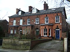
Swinton and Pendlebury is a town in the City of Salford Metropolitan Borough, Greater Manchester, England. It contains 23 listed buildings that are recorded in the National Heritage List for England. Of these, one is listed at Grade I, the highest of the three grades, one is at Grade II*, the middle grade, and the others are at Grade II, the lowest grade. The listed buildings include houses, churches and items in churchyards, a public house, aqueducts, a railway viaduct, cemetery buildings, a bandstand and war memorials.

References

  1. Mills, A.D. (2003), A Dictionary of British Place-Names, Oxford: Oxford University Press, ISBN   0-19-852758-6 (subscription required)
  2. 1 2 Farrer, William; Brownbill, J, eds. (1911), "Clifton", A History of the County of Lancaster: Volume 4, British History Online, pp. 404–406, retrieved 18 June 2011
  3. Clifton Colliery Explosion: A brief description and memorial Durham Mining Museum Archived 2008-12-03 at the Wayback Machine
  4. Morley, Arnold, MP (31 July 1885), Report by Arnold Morley, Esq, M.P., upon the circumstances attending a fatal explosion which occurred on the 18th of June, 1885, in the Trencherbone mine of the Clifton Hall Colliery, 19th Century House of Commons Sessional Papers, 1884-85, Vol.XIV, p.813, HMSO{{citation}}: CS1 maint: multiple names: authors list (link)
  5. Lewis, Samuel (1848), "Clifton", A Topographical Dictionary of England, British History Online, pp. 635–639, retrieved 18 June 2011
  6. Greater Manchester Gazeteer C, Greater Manchester Record Office, archived from the original on 18 July 2011, retrieved 18 August 2017
  7. Clifton Railway Viaduct: A brief description
  8. 1 2 Listed Building Register C – Salford City Council
  9. Clifton Aqueduct on the Manchester Bolton and Bury Canal