
Long Island Sound is a tidal estuary of the Atlantic Ocean, lying predominantly between the U.S. state of Connecticut to the north, and Long Island in New York to the south. From west to east, the sound stretches 110 mi (180 km) from the East River in New York City, along the North Shore of Long Island, to Block Island Sound. A mix of freshwater from tributaries and saltwater from the ocean, Long Island Sound is 21 mi (34 km) at its widest point and varies in depth from 65 to 230 feet.
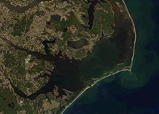
Pamlico Sound in North Carolina in the US is the largest lagoon along the North American East Coast, extending 80 mi (130 km) long and 15 to 20 miles wide. It is part of a large, interconnected network of lagoon estuaries that includes Albemarle Sound, Currituck Sound, Croatan Sound, Pamlico Sound, Bogue Sound, Core Sound, and Roanoke Sound. Together, these sounds, known as the Albemarle-Pamlico sound system, comprise the second largest estuary in the United States, covering over 3,000 sq. mi. of open water. The Pamlico Sound is separated from the Atlantic Ocean by the Outer Banks, a row of low, sandy barrier islands that include Cape Hatteras National Seashore, Cape Lookout National Seashore, and Pea Island National Wildlife Refuge. The Albemarle-Pamlico Sound is one of nineteen great waters recognized by the America's Great Waters Coalition.
John Donald MacArthur was an American businessman and philanthropist who established the John D. and Catherine T. MacArthur Foundation, benefactor in the MacArthur Fellowships.

Ōkārito Lagoon is a coastal lagoon on the West Coast of New Zealand's South Island. It is located 130 kilometres (81 mi) south of Hokitika, and covers an area of about 3,240 hectares (12.5 sq mi), making it the largest unmodified coastal wetland in New Zealand. It preserves a sequence of vegetation types from mature rimu forest through mānuka scrub to brackish water that has been lost in much of the rest of the West Coast. Ōkārito Lagoon is the main feeding ground for New Zealand's only breeding population of rare white heron. The settlement of Ōkārito is at the southern end of the lagoon.

Fripp Island is a 6.546 sq mi (16.954 km²) barrier island located along the Atlantic coast of the lowcountry part of South Carolina. It is approximately 21 miles from Beaufort, 96 miles south of Charleston, and 65 miles north of Savannah, Georgia. Some of the neighboring islands include Hunting Island, Harbor Island, Saint Helena Island, Lady's Island, and Pritchard’s Island. The island mostly serves as a residential vacation resort, but several hundred residents make it their permanent home. It is also the most seaward of the South Carolina Sea Islands. Fripp is renowned for its resort amenities and natural conservation.

The Indian River Lagoon is a grouping of three lagoons: the Mosquito Lagoon, the Banana River, and the Indian River, on the Atlantic Coast of Florida; one of the most biodiverse estuaries in the Northern Hemisphere and is home to more than 4,300 species of plants and animals.

John D. MacArthur Beach State Park, named for John D. MacArthur whose Foundation donated a portion of the land for its construction in the 1970s, is located on and just north of Singer Island, Florida in North Palm Beach, Florida. The park was first opened to the public in 1989. It covers 438 acres (1.8 km2) on land and underwater, including an Estuary crossed by a 1,600-foot (490 m) boardwalk, and Munyon Island, a wilderness isle in the Intracoastal Waterway that was home to the lavish Hygeia Hotel at the turn of the Twentieth century. The hotel burned to the ground in 1917. Hiking trails and pavilions are open for public use on Munyon Island, which is accessible only by kayak or boat.

Big Talbot Island State Park is a state park in Florida, United States. It is located on Big Talbot Island, a coastal barrier island 20 miles east of downtown Jacksonville on A1A North and immediately north of Little Talbot Island State Park along the Atlantic coastal plain.

Cayo Costa State Park is a state park in the U.S. state of Florida, on Cayo Costa, an island directly south of Boca Grande and just north of North Captiva Island, approximately 12 miles (19 km) west of Cape Coral. The park is accessible only by charter boat, private boat, ferry or helicopter.
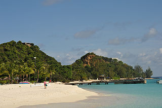
Palm Island in the Grenadines is a small island one mile from Union Island, only accessible by boat. It has an area of 135 acres (0.55 km2) and has five beaches.
The Caloosahatchee culture is an archaeological culture on the Gulf coast of Southwest Florida that lasted from about 500 to 1750 AD. Its territory consisted of the coast from Estero Bay to Charlotte Harbor and inland about halfway to Lake Okeechobee, approximately covering what are now Charlotte, Lee, and Collier counties. At the time of first European contact, the Caloosahatchee culture region formed the core of the Calusa domain.
Bahia Honda is an island in the lower Florida Keys.

Green Cay Wetlands is a nature preserve located in Boynton Beach, Florida. The 100-acre (0.40 km2) property was purchased in 1999 from Ted and Trudy Winsberg, who used the property for farming. The Winsbergs sold the property for 1/3 of its appraised value with the condition that it would be made into a wetland. Construction began in July 2003. It was created jointly by the Palm Beach County Utilities Department and the Palm Beach County Parks and Recreation Department in 2004. This park includes 1.5 miles (2.4 km) of an elevated wooden boardwalk, which takes visitors through various habitats, including cabbage palm hammock, cypress swamp, wetland hammock, and tropical hardwood hammock. The boardwalk also features a Seminole chickee hut as well as several gazebos, which have descriptive signs offering information on the wildlife and plant life.

The Wakodahatchee Wetlands is a park located in Delray Beach, Florida. The park was created on 50 acres (20 ha) of unused utility land and transformed into a recreation wetlands open to the public with a three-quarter mile boardwalk that crosses between open water pond areas, emergent marsh areas, shallow shelves, and islands with shrubs and snags to foster nesting and roosting. The boardwalk has interpretive signage as well as gazebos with benches along the way. This site is part of the South section of the Great Florida Birding Trail and offers many opportunities to observe birds in their natural habitats.

Palm Island is a neighborhood in the city of Miami Beach on a man-made island in Biscayne Bay, Florida, United States; just south of Hibiscus Island. It is a residential neighborhood with high property values, solely accessible by land via the MacArthur Causeway. The entire island has an area of 82 acres (33 ha).

Singer Island is a peninsula on the Atlantic coast of Palm Beach County, Florida, in the South Florida metropolitan area. Most of it is in the city of Riviera Beach, but the town of Palm Beach Shores occupies its southern tip. Its latitude of is 26.784 N and its longitude is −80.037; Florida's easternmost point is in Palm Beach Shores. Before the Palm Beach Inlet was created, Singer Island was connected to the island of Palm Beach to the south.
The 1903 Florida hurricane was an Atlantic hurricane that caused extensive wind and flood damage on the Florida peninsula and over the adjourning Southeastern United States in early to mid September 1903. The third tropical cyclone and third hurricane of the season, this storm was first observed near Mayaguana island in the Bahamas early on September 9. Moving northwestward, it became a hurricane the next day and passed near Nassau. The cyclone then turned to the west-northwest on September 11 and passed just north of the Bimini Islands. As it crossed the Bahamas, the cyclone produced hurricane-force winds that caused damage to crops and buildings, but no deaths were reported over the island chain.

Russian River State Marine Recreational Management Area (SMRMA) and Russian River State Marine Conservation Area (SMCA) are two adjoining marine protected areas in the Russian River estuary area in Sonoma County, California, on the north-central coast of the state. The combined area of these marine protected areas is 1.21 square miles (3.1 km2), with 0.35 square miles (0.91 km2) in the SMRMA and 0.86 square miles (2.2 km2) in the SMCA.

James M. Munyon was an American known for homeopathic patent medicines, some of which he promoted at his Hotel Hygeia on Munyon Island.

Capers Island is a state-owned barrier island on the Atlantic Ocean in Charleston County, South Carolina about 15 miles north of the city of Charleston. It is separated from the mainland by salt marshes and the Intracoastal Waterway. To the southwest it is separated from the barrier island Dewees Island by Capers Inlet. To the northwest, it is separated from the barrier island Bulls Island by Price Inlet.
