Murdoch, Western Australia

Last updated

Murdoch
Perth, Western Australia,  Western Australia
E37 Fiona Stanley Hospital (October 2014) 21.JPG
Fiona Stanley Hospital
Murdoch, Western Australia
Coordinates 32°04′12″S115°50′15″E / 32.0698712°S 115.8375606°E / -32.0698712; 115.8375606 (Murdoch)
Population3,352 (SAL 2021) [1]
Established1974 [2]
Postcode(s) 6150
Location12 km (7 mi) from Perth
LGA(s) City of Melville
State electorate(s) Bateman, Willagee
Federal division(s) Tangney
Suburbs around Murdoch:
Kardinya Winthrop Bateman
Kardinya Murdoch Leeming
Coolbellup North Lake Jandakot

Murdoch is a suburb of Perth, Western Australia, located within the City of Melville. Murdoch University, St John of God Hospital Murdoch and Fiona Stanley Hospital are located in Murdoch. The suburb is named after Sir Walter Murdoch. [2]

Contents

Location

Murdoch is located next to Winthrop, Bateman, Kardinya and North Lake. Boundaries with these suburbs are delineated by Somerville Drive, Murdoch Drive, Prescott Drive and Farrington Road respectively.

Land use

Murdoch's residential area is primarily on the northern side of South Street; the area on the southern side is primarily for commercial usage. While hospitals and educational institutions dominate the suburb's land usage, the area also includes a police station, a fire station, and the minimum-security Wandoo Rehabilitation Prison.

Hospitals

There are two major hospital complexes within Murdoch: the privately owned St John of God Hospital and the Government-operated Fiona Stanley Hospital that opened in October 2014.

Education

Tertiary education institutions Murdoch University and a campus of the South Metropolitan TAFE are located in Murdoch. Kennedy Baptist College caters for students from year 7 to 12. There are no primary schools within the suburb.

Transport

Train & Bus Interchange    Murdoch railway station

Bus

Churches

There are several churches based in the suburb of Murdoch, including Evangel Christian Fellowship; an evangelical church based in Murdoch University since 1991. [19]

Related Research Articles

Dianella is a suburb of Perth, Western Australia. It is within the local government area of the City of Stirling.

<span class="mw-page-title-main">Armadale, Western Australia</span> Suburb of Perth, Western Australia

Armadale is a suburb of Perth within the City of Armadale, located on the south-eastern edge of the Perth metropolitan region. The major junction of the South Western and Albany Highways, which connect Perth with the South West and Great Southern regions of Western Australia respectively, is located within the suburb. It is also the terminus of the Armadale railway line, one of five major railway lines to service Perth.

<span class="mw-page-title-main">Bull Creek, Western Australia</span> Suburb of Perth, Western Australia

Bull Creek is a suburb of Perth, Western Australia, located within the local government area of City of Melville. The suburb lies to the south of a creek of the same name, which flows into the Canning River.

<span class="mw-page-title-main">Leeming, Western Australia</span> Suburb of Perth, Western Australia

Leeming is a southern suburb of Perth, Western Australia. It is divided between the three local government areas of the City of Melville, the City of Cockburn (south) and the City of Canning (north-east). It is located approximately 17 kilometres (11 mi) south of the Perth central business district and 13 kilometres (8.1 mi) east of Fremantle.

<span class="mw-page-title-main">Maddington railway station</span> Railway station in Perth, Western Australia

Maddington railway station is on the Transperth network. It is located on the Armadale Line, 17.7 kilometres from Perth Station serving the suburb of Maddington.

<span class="mw-page-title-main">Thornlie, Western Australia</span> Suburb of Perth, Western Australia

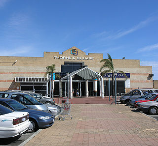
Thornlie is a large residential suburb of Perth, the capital city of Western Australia, located 15 kilometres (9.3 mi) south-east of the city's central business district. It is a part of the City of Gosnells local government area. The Canning River runs through the northern side of the suburb. Since the 1950s the suburb has developed in approximately five stages; north-east Thornlie (1950s–60s), south Thornlie (1970s–80s), Crestwood (1970s), Castle Glen (1980s) and Forest Lakes.

<span class="mw-page-title-main">Carlisle, Western Australia</span> Suburb of Perth, Western Australia

Carlisle is a suburb of Perth, Western Australia. Its local government area is the Town of Victoria Park.

Bateman is a suburb of Perth, Western Australia, located within the City of Melville.

<span class="mw-page-title-main">Winthrop, Western Australia</span> Suburb of Perth, Western Australia

Winthrop is a southern suburb of Perth, Western Australia, located within the City of Melville.

<span class="mw-page-title-main">Canning Vale, Western Australia</span> Suburb of Perth, Western Australia

Canning Vale is a southern suburb of Perth, 22 km (13.7 mi) from the central business district. Its local government areas are the City of Canning and the City of Gosnells.

<span class="mw-page-title-main">Willetton, Western Australia</span> Suburb of Perth, Western Australia

Willetton is a large southern suburb of Perth, Western Australia. Its local government area is the City of Canning.

<span class="mw-page-title-main">Spearwood, Western Australia</span> Suburb of Perth, Western Australia

Spearwood is a southern suburb of Perth, Western Australia, located within the City of Cockburn. This suburb derives its name from the Spearwood bush which is a common shrub in the area.

Success is a southern suburb of Perth, the capital city of Western Australia, located within the City of Cockburn.

South Fremantle is a suburb of Perth, Western Australia, located within the City of Fremantle.

<span class="mw-page-title-main">Hilton, Western Australia</span> Suburb of Perth, Western Australia

Hilton is a suburb of Perth, Western Australia, located within the City of Fremantle.

<span class="mw-page-title-main">Beaconsfield, Western Australia</span> Suburb of Perth, Western Australia

Beaconsfield is a suburb of Perth, Western Australia, located within the City of Fremantle. It was named after a property of the same name in the area in the 1880s; the name was officially adopted from the post office on 1 August 1894. The name's origin is unknown, but it probably comes from the town in England or the Earl of Beaconsfield, Benjamin Disraeli, a former Conservative Prime Minister of the United Kingdom.

<span class="mw-page-title-main">Southern River, Western Australia</span> Suburb of Perth, Western Australia

Southern River is a suburb of Perth, Western Australia, located within the City of Gosnells.

<span class="mw-page-title-main">Seville Grove, Western Australia</span> Suburb of Perth, Western Australia

Seville Grove is a suburb of Perth, Western Australia in the City of Armadale.

<span class="mw-page-title-main">Gosnells, Western Australia</span> Suburb of Perth, Western Australia

Gosnells is a suburb located within the City of Gosnells. Gosnells is approximately 20 kilometres (12 mi) south-east of the Perth central business district. It contains the Gosnells town centre which includes the Council offices, library and the Gosnells Railway Station.

<span class="mw-page-title-main">Fremantle (suburb)</span> Suburb of Perth, Western Australia

Fremantle is a Western Australian suburb located in Perth at the mouth of the Swan River, and is situated 18 kilometres (11 mi) from the Perth central business district. One of the original settlements of the Swan River Colony established in 1829 is within the area known today as this suburb.

References

  1. Australian Bureau of Statistics (28 June 2022). "Murdoch (suburb and locality)". Australian Census 2021 QuickStats. Retrieved 28 June 2022.  OOjs UI icon edit-ltr-progressive.svg
  2. 1 2 "History of metropolitan suburb names – M". Western Australian Land Information Authority. Archived from the original on 16 March 2022. Retrieved 17 October 2011.
  3. "Route 998". CircleRoute Timetable 200 (PDF). Transperth. 29 August 2023 [effective from 20 November 2023].
  4. "Route 999". CircleRoute Timetable 200 (PDF). Transperth. 29 August 2023 [effective from 20 November 2023].
  5. "Route 204". Bus Timetable 1 (PDF). Transperth. 24 August 2023 [effective from 20 November 2023].
  6. "Route 205". Bus Timetable 1 (PDF). Transperth. 24 August 2023 [effective from 20 November 2023].
  7. "Route 206". Bus Timetable 18 (PDF). Transperth. 28 August 2022 [effective from 20 November 2022].
  8. "Route 207". Bus Timetable 18 (PDF). Transperth. 28 August 2022 [effective from 20 November 2022].
  9. "Route 503". Bus Timetable 47 (PDF). Transperth. 12 June 2019 [effective from 21 July 2019].
  10. "Route 504". Bus Timetable 47 (PDF). Transperth. 12 June 2019 [effective from 21 July 2019].
  11. "Route 505". Bus Timetable 47 (PDF). Transperth. 12 June 2019 [effective from 21 July 2019].
  12. "Route 511". Bus Timetable 37 (PDF). Transperth. 13 March 2023 [effective from 2 April 2023].
  13. "Route 512". Bus Timetable 37 (PDF). Transperth. 13 March 2023 [effective from 2 April 2023].
  14. "Route 513". Bus Timetable 37 (PDF). Transperth. 13 March 2023 [effective from 2 April 2023].
  15. "Route 514". Bus Timetable 116 (PDF). Transperth. 5 March 2020 [effective from 5 April 2020].
  16. "Route 517". Bus Timetable 4 (PDF). Transperth. 11 January 2024 [effective from 28 January 2024].
  17. "Route 518". Bus Timetable 17 (PDF). Transperth. 11 January 2024 [effective from 28 January 2024].
  18. "Route 519". Bus Timetable 17 (PDF). Transperth. 11 January 2024 [effective from 28 January 2024].
  19. "Evangel Christian Fellowship" . Retrieved 8 January 2009.

Commons-logo.svg Media related to Murdoch, Western Australia at Wikimedia Commons