In 1857, Arthur Hill, 4th Marquess of Downshire built Murlough House as a summer residence on the peninsula. A wooden bridge was built connecting to Keel Point, replaced in 1893 with the current granite one.[4]
The house and sand dunes were extensively used by the US Army during the Second World War.[5] In 1942 the US 1st Battalion, 13th Armored (1st Division) arrived followed by the 818th Tank Destroyer Battalion (XV Corps) in April 1944.[6]
Several rare moths and butterflies can be found within the reserve. 23 butterfly species have been recorded at Murlough NNR, the marsh fritillary (Euphydryas aurinia), is of European importance - other notable species include dark-green fritillary (Argynnis aglaja), grayling (Hipparchia semele) and cryptic wood white (Leptidea juvernica). One species, the wall brown butterfly (Lasiommata megera) has not been recorded for several years. 787 species of moth have been recorded at Murlough Nature Reserve - examples include small elephant hawkmoth (Deilephila porcellus), sand dart (Agrotis ripae) and the micro moths Pyrausta cingulata and Hysterophora maculosana. A total of 810 Lepidoptera (butterflies and moths) have been recorded within the nature reserve boundary.
Notable migrant species noted in the area have included: cosmopolitan (Leucania loreyi), white-speck, the delicate. In 2012 a Stephens' gem (Megalographa biloba) was recorded at Murlough NNR - this was the 1st record for Ireland of this North American species.
Gallery
Landscape, February 2010
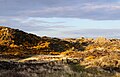
Gorse-covered dunes, May 2021
Gorse burning, February 2010
Exmoor ponies at Murlough, used for grazing management
This page is based on this Wikipedia article Text is available under the CC BY-SA 4.0 license; additional terms may apply. Images, videos and audio are available under their respective licenses.