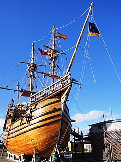
Museo Nao Victoria

Last updated
Museo Nao Victoria (Chile)
ReplicaNaoVictoriaMagallanes.jpg
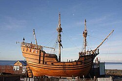
Nao Victoria Replica in the museum
Established2011
LocationPunta Arenas, Chile
Type Maritime Museum
Website https://www.registromuseoschile.cl/663/w3-article-83699.html

The Nao Victoria Museum is located in Punta Arenas, Chile, and has been open to the public since 1 October 2011. The museum is private, the owner has received the Medal of the President of Chile for his work in promoting national identity during the celebrations for the bicentenary of the independence of the South American country. [1] Spanish Vice Consul in Punta Arenas gave the entrepreneur the prize "Hispanic Identity" for the building of the Nao Victoria Replica. [2]

Contents

A visitor dressed as a Spanish Conquistador, part of the interactive programs in the museum Museo Nao Victoria Visitante vestido de soldado espanol.JPG
A visitor dressed as a Spanish Conquistador, part of the interactive programs in the museum

Aim of the Museo Nao Victoria

The museum's goal is to be interactive and offer its visitors the experience of interacting with replicas of the ships that contributed to the discovery of the area, colonization of the territory, or have a special and historic heritage significance for the Magallanes Region of Chile. The replicas were built using traditional shipbuilding techniques.

Collections

The main collection of the museum is the full-size replicas of historic ships on display along the Straits of Magellan. Replicas of weapons and ancient navigation tools are also exhibited as well as copies of documents and books relating to the historic ships and an outdoor shipbuilding workshop.

Replicas

Today the museum has three ship replicas:

Nao Victoria

Nao Victoria , was a carrack, 27 metres (89 ft) long, 7 metres (23 ft) wide, that was part of the fleet commanded by Ferdinand Magellan that discovered the waterway around southern tip of the South American continent. Later, commanded by Juan Sebastian Elcano, she was the only ship of the five to complete the first-time circumnavigation of the globe. Commanded by Duarte Barbosa, Nao Victoria participated in the Discovery of Chile, being the first to explore the region in 1520, and discovering or naming Patagonia, Cape Virgenes, the Straits of Magellan, Tierra del Fuego, the Pacific Ocean and other milestones.

She is one of the most famous ships in history of navigation.

James Caird

James Caird, was a lifeboat of the Endurance, adapted by Harry McNish, and sailed from Elephant Island to South Georgia during Sir Ernest Shackleton's 1916 Imperial Trans-Antarctic Expedition. Many historians[ who? ] consider the feat of the crew of James Caird to be the most impressive of all global navigation.

Schooner Ancud

Ancud was the ship that, under an 1843 mandate of the President of Chile, Manuel Bulnes, claimed the Strait of Magellan on behalf of Chile's newly independent government, building Fort Bulnes. Commander of the schooner was Captain John Williams Wilson. On 31 December 2011, the museum announced the construction of a replica of the schooner in its shipbuilding workshop; [3] the replica Ancud was opened to public on 5 September 2012.

HMS Beagle

HMS Beagle, a British Navy brig-sloop, was converted into an exploration vessel. The most famous of her three trips was the second one under the command of Captain FitzRoy. On board was the young Charles Darwin. HMS Beagle remained in the Magellan región for almost three years, and the observations made by Darwin were influential in the development of his theory of evolution. The construction of the full-size HMS Beagle replica started in November 2012. [4] Four years later, in November 2016, the museum announced that the vessel was completed. [5]

Other collections

Shipbuilding workshop

During summer 2013 the shipbuilding workshop of the museum built a one third size scale replica of an 18th-century galleon. [6]

See also

Related Research Articles

<span class="mw-page-title-main">Strait of Magellan</span> Strait in southern Chile between the Atlantic and Pacific

The Strait of Magellan, also called the Straits of Magellan, is a navigable sea route in southern Chile separating mainland South America to the north and Tierra del Fuego to the south. The strait is considered the most important natural passage between the Atlantic and Pacific oceans. It was navigated by canoe-faring indigenous peoples including the Kawésqar for thousands of years. The strait is approximately 570 km long and 2 km wide at its narrowest point. In 1520, the Spanish expedition of Ferdinand Magellan, after whom the strait is named, became the first Europeans to discover it.

<span class="mw-page-title-main">Southernmost settlements</span> Worlds most southerly settlements

Southernmost settlements are cities, towns, weather stations or permanent military bases which are farther south than latitude 45°S. They are closely related to the Southern Ocean or either the Roaring Forties or Furious Fifties. Antarctic bases are excluded due to not having a permanent population.

<span class="mw-page-title-main">Puerto Williams</span> City in Magallanes y Antártica Chilena Region, Chile

Puerto Williams is a city, port and naval base on Navarino Island in Chile, and is also the southernmost populated settlement in the world. It faces the Beagle Channel. It is the capital of the Chilean Antarctic Province, one of four provinces in the Magellan and Chilean Antarctica Region, and administers the communes of Chilean Antarctic Territory and Cabo de Hornos. It has a population of 2,874, including both naval personnel and civilians. Puerto Williams claims the title of world's southernmost city. The settlement was founded in 1953, and was first named Puerto Luisa. The town was later named after John Williams Wilson, a British man who founded Fuerte Bulnes, the first settlement in the Strait of Magellan. It has served primarily as a naval base for Chile. The Chilean Navy runs the Guardiamarina Zañartu Airport and hospital, as well as nearby meteorological stations. Since the late 20th century, the number of navy personnel has decreased in Puerto Williams and the civilian population has increased. In that period, tourism and support of scientific research have contributed to an increase in economic activity.

<i>Victoria</i> (ship) Carrack used in Ferdinand Magellans expeditions; first ship to circumnavigate the globe

Victoria or Nao Victoria was a carrack famed as the first ship to successfully circumnavigate the world. Victoria was part of the Spanish expedition to the Moluccas commanded by the explorer Ferdinand Magellan.

<span class="mw-page-title-main">Ship replica</span> Reconstruction of a no longer existing ship

A ship replica is a reconstruction of a no longer existing ship. Replicas can range from authentically reconstructed, fully seaworthy ships, to ships of modern construction that give an impression of a historic vessel. Some replicas may not even be seaworthy, but built for other educational or entertainment purposes.

<span class="mw-page-title-main">Puerto del Hambre</span> Historic settlement in Chile

Ciudad del Rey Don Felipe, also known as Puerto del Hambre, is a historic settlement site at Buena Bay on the north shore of the Strait of Magellan approximately 58 km (36 mi) south of Punta Arenas in the Región de Magallanes y la Antártica Chilena, Patagonia, Chile.

<span class="mw-page-title-main">Puerto Natales</span> City in Magallanes y Antártica Chilena, Chile

Puerto Natales is a city in Chilean Patagonia. It is the capital of both the commune of Natales and the province of Última Esperanza, one of the four provinces that make up the Magallanes and Antartica Chilena Region in the southernmost part of Chile. Puerto Natales is the only city in the province. It is located 247 km (153 mi) northwest of Punta Arenas. It is the final passenger port of call for the Navimag ferry sailing from Puerto Montt into the Señoret Channel as well as the primary transit point for travellers to Torres del Paine National Park, Chile.

<span class="mw-page-title-main">Chilean Sea</span> Portion of the Pacific Ocean lying west of the Chilean mainland

The Chilean Sea is the portion of the Pacific Ocean lying west of the Chilean mainland. The official Chilean usage for Chilean Sea was defined on 30 May 1974 when the Diario oficial de la Republica de Chile published Supreme Decree #346, which declared that "the waters surrounding or touching the shores of the national territory shall be known as Mar Chileno."

<span class="mw-page-title-main">Lighthouses in Chile</span>

Chile has a large and intricate coastline of 4000 km with myriads of islands, islets, straits, bays, and fjords.

<span class="mw-page-title-main">Punta Arenas</span> Place in Magallanes y Antártica Chilena, Chile

Punta Arenas is the capital city of Chile's southernmost region, Magallanes and Antarctica Chilena. Although officially renamed as Magallanes in 1927, the name was changed back to Punta Arenas in 1938. The city is the largest south of the 46th parallel south and the most populous southernmost city in Chile and the Americas. Due to its location, it is also the coldest coastal city with more than 100,000 inhabitants in Latin America. Punta Arenas is one of the world's most southerly ports and serves as an Antarctic gateway city.

<span class="mw-page-title-main">Mount Tarn</span> Mountain in Chile

Mount Tarn is a small mountain located on the southernmost part of the Strait of Magellan, in Brunswick Peninsula, about 70 km south of Punta Arenas, Chile. It is in the southern extreme of continental Chile very close to Cape Froward, surrounded by historic places such as Fort Bulnes and Puerto del Hambre.

<span class="mw-page-title-main">Fuerte Bulnes</span> Chilean fort

Fuerte Bulnes is a Chilean fort located by the Strait of Magellan, 62 km south of Punta Arenas. It was founded in 1843 on a rocky hill at Punta Santa Ana, and named after President Manuel Bulnes Prieto.

Operación Soberanía was a planned Argentine military invasion of Chile due to the Beagle conflict. The invasion was initiated on 22 December 1978 but was halted after a few hours and Argentine forces retreated from the conflict zone without a fight. Whether the Argentine infantry actually crossed the border into Chile has not been established. Argentine sources insist that they crossed the border.

<span class="mw-page-title-main">John Williams Wilson</span> 19th-century English-Chilean sailor and politician

John Williams Wilson (1798–1857), also known as Juan Guillermos, was an English-Chilean sailor and politician. Born in Bristol, he entered the newly founded Chilean navy in 1824 and rose to the rank of commander. He was appointed governor of Talcahuano (1849–1855). He supervised construction of Fuerte Bulnes in 1843, which the government intended for a settlement at the Strait of Magellan. Puerto Williams, founded in 1953, was named for the naval commander.

The southern coast of Chile presents a large number of fjords and fjord-like channels from the latitudes of Cape Horn to Reloncaví Estuary. Some fjords and channels are important navigable channels providing access to ports like Punta Arenas, Puerto Chacabuco and Puerto Natales.

<span class="mw-page-title-main">José Menéndez</span> Spanish businessman and perpetrator of the Selknam genocide (1846–1918)

José Menéndez Menéndez (1846–1918) was a Spanish businessman based in Argentina and Chilean Patagonia. He was the initiator of many large companies that remain to this day.

<span class="mw-page-title-main">Tierra del Fuego gold rush</span> 1883–1906 gold rush in Argentina

Between 1883 and 1906 Tierra del Fuego experienced a gold rush attracting many Chileans, Argentines and Europeans to the archipelago, including many Dalmatians. The gold rush led to the formation of the first towns in the archipelago and fueled economic growth in Punta Arenas. After the gold rush was over, most gold miners left the archipelago, while the remaining settlers engaged in sheep farming and fishing. The rush made a major contribution to the genocide of the indigenous Selk'nam people.

Chilean schooner <i>Ancud</i> (1843) Schooner of the Chilean Navy, in service from 1843 to 1846

The schooner Ancud was the ship sent by Chile in 1843 to claim sovereignty over the Strait of Magellan and establish Fuerte Bulnes, the first Chilean settlement in the strait. It was built for the purpose in the city of San Carlos de Ancud and commanded by John Williams Wilson, a British-born Chilean captain.

Puerto Americano is a natural harbour in the fjords and channels of Patagonia. The harbour lies southwest of Tangbac Island near where the west-east Nihualac Channel meets the north-south Moraleda Channel in Aysén Region.

Chilean colonization of the Strait of Magellan began in 1843 when an expedition founded Fuerte Bulnes. In 1848 the settlement of Punta Arenas was established further north in the strait and grew eventually to become the main settlement in the strait, a position it holds to this day. The Chilean settlement of the strait was crucial to establish its sovereignty claims in the area. Argentina formally recognised Chilean sovereignty in 1881. The Magallanes territory was made a regular Chilean province in 1928.

References

  1. "Presidente Sebastian Pinera expreso compromiso..." Radio Natales (in Spanish). 16 August 2010. Archived from the original on 9 September 2012. Retrieved 2012-09-20.
  2. "Día de la Hispanidad" (pdf). La Prensa Austral (in Spanish). 18 October 2011. Retrieved 2012-10-13.[ permanent dead link ]
  3. "Construirán réplicas navegables de la goleta Ancud y del bergantín Beagle". La Prensa Austral (in Spanish). 31 December 2011. Archived from the original on 2013-11-01. Retrieved 2012-09-20.
  4. "Construyen Replica del HMS Beagle". radiopolar.com (in Spanish). 15 November 2012. Retrieved 2012-11-16.
  5. "Réplica de la embarcación HMS Beagle fue terminada tras cuatro años de construcción". La Prensa Austral (in Spanish). 27 November 2016. Retrieved 7 April 2019.
  6. "The 1:3 replica of a galleon of the eighteenth century". April 28, 2014. Retrieved 2014-04-29.

Commons-logo.svg Media related to Museo Nao Victoria (Chile) at Wikimedia Commons

53°06′28″S70°52′47″W / 53.10768°S 70.879832°W / -53.10768; -70.879832