
Majalengka Regency is the landlocked regencies (kabupaten) in West Java, Indonesia. It covers an area of 1,204.24 sq. km, and had a population of 1,166,473 at the 2010 Census and 1,305,476 at the 2020 Census; the official estimate as of mid-2023 was 1,340,617. The administrative capital is the town of Majalengka.
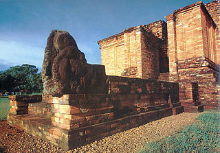
Muaro Jambi Regency is a regency of Jambi Province, Sumatra, Indonesia. It was created on 4 October 1999 by the separation of what were formerly the eastern districts of Batang Hari Regency. It surrounds on all sides the major city of Jambi, the provincial capital, and includes many of the expanding suburbs of Jambi outside the city boundaries; consequently it has experienced population growth greater than elsewhere in the province. From the 4th until the 13th century, it was the seat of the Hindu-Buddhist Melayu Kingdom. It has an area of 5,264.00 km2 and had a population of 342,952 at the 2010 census and 390,347 at the 2020 census; the official estimate as at mid 2023 is 418,799.

Indragiri Hilir is the most eastern regency (kabupaten) of Riau Province, Indonesia. It is located on the island of Sumatra. The regency has an area of 13,136.14 km2 and had a population of 661,779 at the 2010 census and 654,909 at the 2020 Census; the official estimate as at mid 2023 was 695,571. The administrative centre of the regency is the town of Tembilahan.

Kuantan Singingi is an inland regency (kabupaten) of Riau Province, Indonesia. It is located on the island of Sumatra. The regency was created on 4 October 1999 from what had been the western half of Indragiri Hulu Regency. It has an area of 7,656.03 km2 and had a population of 292,116 at the 2010 Census and 334,943 at the 2020 Census; the official estimate as at mid 2022 was 356,246. The seat of the regency is the town of Teluk Kuantan.

Lubuklinggau, is a city in South Sumatra, Indonesia. It has an area of 401.50 km2 and had a population of 201,308 at the 2010 Census and 234,166 at the 2020 Census; the official estimate as at mid 2023 was 241,894. The city was formerly part of the Musi Rawas Regency from which it was separated on 21 June 2001.
Central Hulu Sungai Regency is one of the regencies in the Indonesian province of South Kalimantan. The area is 1,770.77 km2 and the population was 243,460 at the 2010 Census and 258,721 at the 2020 Census; the official estimate as at mid 2023 was 268,360. The administrative centre is the town of Barabai.

North Hulu Sungai Regency is one of the regencies in the Indonesian province of South Kalimantan. It was created on 26 June 1959 from the trifurcation of the original Hulu Sungai Regency and formerly covered a much larger area in the north of the province, but on 14 July 1965 the northern districts were split off to create a separate Tabalong Regency, and on 25 February 2003 the eastern districts were split off to create a separate Balangan Regency. It now has a land area of 907.72 km2, and had a population of 209,246 at the 2010 Census and 226,727 at the 2020 Census; the official estimate as of mid-2023 was 233,412. The capital of the regency is the town of Amuntai.

Brebes is a regency in the northwestern part of Central Java province in Indonesia. It covers an area of 1,769.62km2, and it had a population of 1,733,869 at the 2010 Census and 1,978,759 at the 2020 Census; the official estimate as at mid 2023 was 2,043,077. Its capital is the large town of Brebes in the northeast corner of the regency, immediately adjacent to the neighbouring city of Tegal.

Lahat Regency is a regency of South Sumatra province, Indonesia. It originally included much of the southwestern part of the province, but on 21 June 2001 the town of Pagar Alam was removed from the regency to become an independent city, and on 2 January 2007 the western districts were split off to form the new Empat Lawang Regency. The reduced regency now covers a total area of 4,361.84 km2 and had a population of 369,974 at the 2010 Census and 430,071 at the 2020 Census; the official estimate as at mid 2023 was 438,238. The city of Pagar Alam remains an enclave within the regency, but is administratively separate.

Batanghari is a regency of Jambi Province in Sumatra, Indonesia. It originally covered a wider area, but on 4 October 1999 this was split between a new Muaro Jambi Regency in the east and a reduced Batang Hari Regency in the west, which now covers an area of 5,804.83 km2. It had a population of 241,334 at the 2010 census and 301,700 at the 2020 census; the official estimate as at mid 2023 was 312,279. The administrative capital is the town of Muara Bulian(Bulian Estuary or Bulian Delta).

Bungo Regency is a regency (kabupaten) of Jambi Province in Sumatra, Indonesia. It was created on 4 October 1999 by the division of the former Bungo Tebo Regency into a new Tebo Regency in the west and this Bungo Regency in the east. The Bungo Regency covers an area of 4,659 km2. As at the 2010 census, the regency had a population of 303,135 and 362,363 at the 2020 census; the official estimate as at mid 2023 was 376,382 - comprising 191,594 males and 184,788 females. The administrative capital is the town of Muara Bungo.

Banyuasin is a regency of South Sumatra Province in Indonesia. The Regency was formed on 10 April 2002 from the coastal and eastern areas formerly part of the Musi Banyuasin Regency. It takes its name from the main river which drains that area, the Banyuasin River. Pangkalan Balai is the regency seat. The regency borders Musi Banyuasin Regency, Jambi province and Bangka Strait to the north, Bangka Strait to the east, Ogan Komering Ilir Regency, Muara Enim Regency, and the city of Palembang to the south, and Musi Banyuasin Regency to the west. It has an area of 12,551.15 km2 and had a population of 749,107 at the 2010 census and 836,914 at the 2020 census; the official estimate as at mid 2023 was 850,022. Much of the regency is coastal lowland.

Empat Lawang Regency is a regency of South Sumatra Province, Indonesia. It was created on 2 January 2007 from what had been formerly the western districts of Lahat Regency. It covers an area of 2,256.44 km² and had a population of 221,176 at the 2010 Census and 333,622 at the 2020 Census; the official estimate as at mid 2023 was 336,694. The regency seat is at the town of Tebing Tinggi.

Musi Rawas Regency is a regency of South Sumatra Province, Indonesia. Prior to 2013, it covered an area of 12,134.57 km2 and had a population of 524,919 at the 2010 Census; however on 10 June 2013 the northern half of the regency was split off to form a separate North Musi Rawas Regency. Previous to 2001, the Regency had also included the city of Lubuklinggau, which was split off to form an independent city outside the regency.
Ogan Komering Ilir Regency is a regency of South Sumatra Province, Indonesia. It takes its name from the Ogan River and the Komering River, which are the two main rivers that drain the area. The name Ilir means downstream. The administrative centre is the town of Kayu Agung. The regency borders Banyuasin Regency to the northwest, Bangka Strait, and the Java Sea to the east, Lampung Province to the south, and Palembang city, Ogan Ilir Regency, and East Ogan Komering Ulu Regency to the west.

Central Lampung Regency is a regency of the province of Lampung, on Sumatra, Indonesia. On 20 April 1999, two areas were separated from the original regency - the southeastern portion was split off to form a separate East Lampung Regency, while the town of Metro was created as an independent city. The reduced regency has an area of 4,559.57 km2 and had a population of 1,170,048 people at the 2010 census and 1,460,045 at the 2020 census; the official estimate as at mid 2023 was 1,508,331. The regency seat is the town of Gunung Sugih.

Penukal Abab Lematang Ilir Regency is a regency of South Sumatra Province, Indonesia. It takes its name from the three main rivers which flow through that area - the Penukal River, Abab River and Lematang River - while the name Ilir means "downstream". The town of Talang Ubi is the administrative centre of this regency. The regency borders Musi Banyuasin Regency to the north, Banyuasin Regency, and Muara Enim Regency to the east and the south, and by Musi Rawas Regency, and Muara Enim Regency to the west.

North Musi Rawas Regency is a regency of South Sumatra Province, Indonesia. It takes its name from the two main river which drain that area, Musi River and Rawas River. This regency was created on 10 June 2013 by splitting off the seven northernmost districts of Musi Rawas Regency.

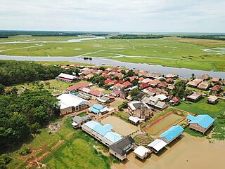
Sekayu is a town and district which serves as the administrative centre of Musi Banyuasin Regency within South Sumatra Province, Sumatra, Indonesia. The district's population was 78,637 at the 2010 Census and 91,120 at the 2020 Census; the official estimate as at mid 2023 was 99,589. The district comprises 14 small towns and villages, of which 4 are kelurahan and ten are desa as follows:

