Musical Stones of Skiddaw

Last updated

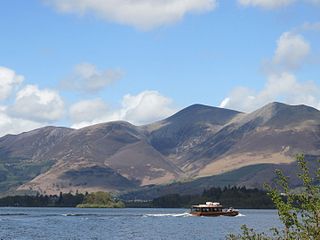
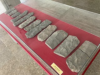
The Musical Stones of Skiddaw are a number of lithophones built across two centuries around the town of Keswick, northern England, using hornfels, a stone from the nearby Skiddaw mountain, which is said to have a superior tone and longer ring than the more commonly used slate.[1]

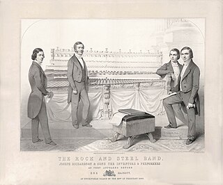
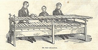
The first documented lithophone from Keswick was built in 1785 by Peter Crosthwaite, an eccentric inventor who became interested in the musical properties of the local stone. However, this kind of instrument became widely known only decades later, when in 1840 Joseph Richardson, a local stonemason and self-taught musician, built a larger, eight-octave lithophone with which he and his sons toured the UK and Europe giving numerous concerts, including one in London for Queen Victoria.[2]

Richardson's lithophone initially featured 61 tuned and shaped hornfels rocks. It was later enhanced with steel bars, Swiss bells and various other percussions, and survives to this day, being on display at the Keswick Museum and Art Gallery.

The matter of exactly where Joseph Richardson sourced the stones for his xylophone has been given some considerable attention in recent years, thanks to the efforts of Dr. Alan Smith and Professor Bruce Yardley from the School of Earth and Environment at the University of Leeds.

An outcrop of hornfels at Sinen Gill Sinen Gill 15.jpg
An outcrop of hornfels at Sinen Gill

The few references to the source of the stones are vague and contradictory. The stones, not only for the Richardson set but also for the Crosthwaite and Greenip sets, as well as further sets that were collected later, are all hornfels, a material that is only found in the Lake District within the inner aureole of the Skiddaw granite, and this narrows the area from where they could have come. The makes a comment by Peter Crosthwaite in his journal of 10th June 1785 very confusing, as the River Greta does not fall within this area.

Sinen Gill Sinen Gill 14.jpg
Sinen Gill

A geologist named James Clifton Ward, who, before he became curate of St. John’s, Keswick, in 1880, had carried out excellent work surveying the northern part of the Lake District as part of the first Geological Survey of the district, whilst not actually pinpointing the exact location, refers to an area that he describes as being “the junction with the granite of Sinen Gill”,[3] more or less midway between Skiddaw and Blencathra, and this is reasonable cause for belief that this may very likely have been where Joseph sourced his stones.

A piece of hornfels, Sinen Gill Sinen Gill 17.jpg
A piece of hornfels, Sinen Gill

Further research has been carried out over the years in an effort to pinpoint the exact source of the stones. In 1967, E.H. Shackleton, in his book Lakeland Geology – Where to go, What to see located the source as the streamside of Roughton Gill, a short way south of Sinen Gill, and this view has been supported by several other sources.[4] However, Smith and Yardley state that: “Close examination of the streamside of Roughton Gill certainly reveals much evidence of quarrying of the bedrock. However the material does not have a good ring and the slabs come away in much thicker and more irregular pieces than the 2.5 3 cm thick pieces in the musical stones. It would seem more likely that this site was used as a source of building slabs for the nearby mine buildings.”[5]

All evidence points to the area of Sinen Gill being the most likely source of the stones. Smith and Yardley, in a research paper published for the Cumberland Geological Society in 2008, wrote: “The upper part of the Sinen Gill valley looks like a very likely source of material that could have been shaped into musical stones. The granite is only clearly exposed along a section of the stream bed of Sinen Gill for about 170m. On the spur top approximately 100m south of the Gill there are some huge granite slabs exposed at the surface (over 5m in length), which may be in situ. The hornfels is well exposed in this area with prominent crags on both sides of the valley and large areas of loose slabby scree. The material has a very strong bedded fabric and importantly is seen to break relatively easily into flat slabs close to the optimum thickness of 2.5-3cm seen in the musical stones. Thin slabs throughout this area ring when struck with a geological hammer.”

Another consideration is that the area of Sinen Gill would have been reasonably accessible for Joseph. Reports exist of the Richardson family taking outings to the fells with a horse and cart in the search for possible stones, with potential pieces being conveyed back to Applethwaite in readiness for Joseph to spend long hours shaping and tuning the slabs to the required size and note. The well-graded and wide mine track up to the area from Threlkeld would have provided easy access for horses and carts, whereas the area of the inner aureole beyond Sinen Gill does not have any suitable tracks.

That said, it is a remote location, standing at 1,805 feet and about 6.2 miles from Keswick, and not much less from Applethwaite, with only a handful of mine trackways and fellside paths for access.[6]

Related Research Articles

<span class="mw-page-title-main">Metamorphic rock</span> Rock that was subjected to heat and pressure

Metamorphic rocks arise from the transformation of existing rock to new types of rock in a process called metamorphism. The original rock (protolith) is subjected to temperatures greater than 150 to 200 °C and, often, elevated pressure of 100 megapascals (1,000 bar) or more, causing profound physical or chemical changes. During this process, the rock remains mostly in the solid state, but gradually recrystallizes to a new texture or mineral composition. The protolith may be an igneous, sedimentary, or existing metamorphic rock.

<span class="mw-page-title-main">Metamorphism</span> Change of minerals in pre-existing rocks without melting into liquid magma

Metamorphism is the transformation of existing rock to rock with a different mineral composition or texture. Metamorphism takes place at temperatures in excess of 150 °C (300 °F), and often also at elevated pressure or in the presence of chemically active fluids, but the rock remains mostly solid during the transformation. Metamorphism is distinct from weathering or diagenesis, which are changes that take place at or just beneath Earth's surface.

<span class="mw-page-title-main">Keswick, Cumbria</span> Town and Civil Parish in Cumbria, England

Keswick is a market town and civil parish in the Cumberland unitary authority area of Cumbria, England. Historically, until 1974, it was part of the county of Cumberland. It lies within the Lake District National Park, Keswick is just north of Derwentwater and is four miles from Bassenthwaite Lake. The parish had a population of 5,243 at the 2011 census.

<span class="mw-page-title-main">Skiddaw</span> Mountain in the Lake District, England

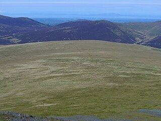
Skiddaw is a mountain in the Lake District National Park in England. Its 931-metre (3,054 ft) summit is the sixth-highest in England. It lies just north of the town of Keswick, Cumbria, and dominates the skyline in this part of the northern lakes. It is the simplest of the Lake District mountains of this height to ascend and, as such, many walking guides recommend it to the occasional walker wishing to climb a mountain. This is the first summit of the fell running challenge known as the Bob Graham Round when undertaken in a clockwise direction.

<span class="mw-page-title-main">Merrivale, Devon</span> Village in Devon, England

Merrivale is a locality in western Dartmoor, in the West Devon district of Devon, England. It is best known for the nearby series of Bronze Age megalithic monuments to the south and a former granite quarry.

<span class="mw-page-title-main">Hornfels</span>

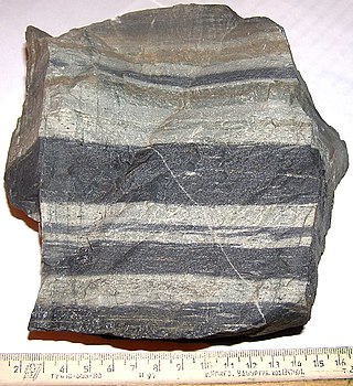
Hornfels is the group name for a set of contact metamorphic rocks that have been baked and hardened by the heat of intrusive igneous masses and have been rendered massive, hard, splintery, and in some cases exceedingly tough and durable. These properties are caused by fine grained non-aligned crystals with platy or prismatic habits, characteristic of metamorphism at high temperature but without accompanying deformation. The term is derived from the German word Hornfels, meaning "hornstone", because of its exceptional toughness and texture both reminiscent of animal horns. These rocks were referred to by miners in northern England as whetstones.

<span class="mw-page-title-main">Dale Head</span> Mountain in the Lake District, England

Dale Head is a fell in the north-western sector of the Lake District, in northern England. It is 753 metres or 2,470 foot above sea level and stands immediately north of Honister Pass, the road between Borrowdale and Buttermere.

<span class="mw-page-title-main">Clough Head</span> Mountain in the English Lake District, Cumbria, England

Clough Head is a fell, or hill, in the English Lake District. It marks the northern end of the main ridge of the Helvellyn range and is often walked as part of the ridge walk. The fell stands south of the village of Threlkeld and the A66 road, and it forms the steep eastern side of the tranquil valley of St John's in the Vale.

<span class="mw-page-title-main">Knott, Caldbeck</span> Mountain in the Lake District, England

Knott is a mountain in the northern part of the English Lake District. It is the highest point of the Back o'Skiddaw region, an area of wild and unfrequented moorland to the north of Skiddaw and Blencathra. Other tops in this region include High Pike, Carrock Fell and Great Calva. The fell's slopes are mostly smooth, gentle, and covered in grass, with a few deep ravines. It stands a long way from a road and requires a long walk across the moor top get to it; this, as well as the fact that it is hidden from the rest of the Lake District by the two aforementioned giants, make it one of the most unfrequented tops in the Lakes. When it is climbed it is most often from Mungrisdale or from the north via Great Sca Fell. The word Knott is of Cumbric origin, and means simply "hill".

<span class="mw-page-title-main">Mungrisdale Common</span> Mountain in the Lake District, England

Mungrisdale Common, pronounced mun-grize-dl, with emphasis on grize, is a fell in the English Lake District. Although Alfred Wainwright listed it as one of the 214 featured hills in his influential Pictorial Guide to the Lakeland Fells it was his least favourite. He commented that it "has no more pretension to elegance than a pudding that has been sat on". There is some speculation that Wainwright included the fell in his guide simply as a way to fill space, but that has never been proven. Mungrisdale Common is oddly named, as it is a number of miles from the village of Mungrisdale, which lies in a different river catchment.

<span class="mw-page-title-main">Carrock Fell</span> Mountain in the Lake District, England

Carrock Fell is a fell in the English Lake District, situated in the northern region of the national park, 8 miles north-east of Keswick.

<span class="mw-page-title-main">Watson's Dodd</span>

Watson's Dodd is a fell in the English Lake District, a minor rise on the main ridge of the Helvellyn range in the Eastern Fells, but a prominent shoulder on the west side of that range.

<span class="mw-page-title-main">Great Calva</span> Mountain in the Lake District, England

Great Calva is a fell in the Lake District, England. It is in the Northern Fells, lying roughly at the centre of this region of high ground. As a result, it is distant from roads and quite remote by Lakeland standards. Great Calva stands at the head of a major geological fault running through the centre of the Lake District, and so from the summit it is possible to see all the way south over Thirlmere. The subsidiary summit of Little Calva lies to the west.

<span class="mw-page-title-main">Đàn đá</span>

The đàn đá is a lithophone played by ethnic minority groups in the Central Highlands of Vietnam, in the provinces of Lâm Đồng, Đắk Nông, Đắk Lắk, Gia Lai, and Kon Tum. These provinces are also home of the space of Gong culture listed in UNESCO's World Heritage Site. The word đá means "stone" in Vietnamese, đàn is instrument. The term đàn đá is of recent origin among Vietnamese musicologists, it had also been referred to as a đàn goong, a Vietnamese gong.

<span class="mw-page-title-main">Keswick Museum</span>

Keswick Museum is a local museum based in Keswick in the English Lake District, which exhibits aspects of the landscape, history and culture of the area.

<span class="mw-page-title-main">Joseph Richardson (musician)</span>

Joseph Richardson was born around 1792, in Cumberland, the eldest child of John Richardson and Dinah Williamson. John and Dinah had married at Great Crosthwaite on 5 September 1791. Joseph’s young years were spent at Keswick, where his father was a miller. The Richardsons owned the Low Corn Mill beside the River Greta. After John’s death in 1839, Dinah lived with her second eldest child, Jonathan, and his family at Applethwaite. When Jonathan remarried she moved to a cottage in the village just a few doors away from where Joseph was living with his wife and family.[1] She passed away on 29 February 1852. “On Sunday last, at Applethwaite, near Keswick, Mrs. Dinah Richardson, mother of the owner of the celebrated Rock Band, aged 83, much respected.”[2] “At Applethwaite, Underskiddaw, on the 29th ult., Dinah, relict of Mr. John Richardson, miller, aged 84 years.”[3]

<span class="mw-page-title-main">Geology of the Lake District</span>

The geology of England's Lake District is dominated by sedimentary and volcanic rocks of mainly Ordovician age underpinned by large granitic intrusions. Younger sedimentary sequences outcrop on the edges of the Lake District area, with Silurian to the south, Carboniferous to the north, east, and west and Permo-Triassic to the west and east. The entire area was covered by a Mesozoic sequence that was eroded off during the Paleogene uplift related to the opening of the North Atlantic. During the Quaternary the area was affected by repeated glaciations, which sculpted the current mountainous landscape.

<span class="mw-page-title-main">Rock, Bell, and Steel Band</span> Victorian Musician

The Rock, Bell, and Steel Band is a massive 19th century lithophone, the largest of several such instruments from the 19th century that are collectively known as the “Musical Stones of Skiddaw”.

<span class="mw-page-title-main">Richardson Henderson</span>

Richardson Henderson was a grandson of musician Joseph Richardson, who invented the Rock, Bell, and Steel Band from musical stones on the mountain of Skiddaw in Cumbria.

References

[1] “The Skiddaw Stones”. Soniccouture. Soniccouture Sound Design Ltd. Retrieved 24 April 2015.

[2] “The Musical Stones of Skiddaw”. Allerdale Borough Council. Archived from the original on 19 June 2010. Retrieved 13 July 2014.

[3] “The Geology of the Northern Part of the English Lake District”, by J. Clifton Ward, Assoc. R.S.M., F.G.S., Quarter Sheet 101 S.E. p.11. (H.M.S.O. London 1876).

[4] “Lakeland Geology – Where to go, What to see”, by E.H. Shackleton. (Dalesman Publishing, 1967).

[5] “The Origin of the Musical Stones of Skiddaw”, by Dr. Alan Smith and Professor Bruce Yardley. (published in ‘Proceedings of the Cumberland Geological Society’, Vol. 7, part 3, October 2008).

[6] “The Richardsons of Applethwaite”, by John H. Phillips. (John H. Phillips, 2023).

Further reading