Related Research Articles
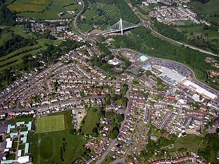
Abercarn is a small town and community in Caerphilly county borough, Wales. It is 10 miles (16 km) northwest of Newport on the A467 between Cwmcarn and Newbridge, within the historic boundaries of Monmouthshire.

The historic counties of Wales are sub-divisions of Wales. They were used for various functions for several hundred years, but for administrative purposes have been superseded by contemporary sub-national divisions, some of which bear some limited similarity to the historic entities in name and extent. They are alternatively known as ancient counties.

Brecknockshire, also known as the County of Brecknock, Breconshire, or the County of Brecon is one of thirteen historic counties of Wales, and a former administrative county. Named after its county town of Brecon, the county is mountainous and primarily rural.
Monmouthshire, also known as the County of Monmouth, is one of thirteen historic counties of Wales and a former administrative county. It corresponds approximately to the present principal areas of Monmouthshire, Blaenau Gwent, Newport and Torfaen, and those parts of Caerphilly and Cardiff east of the Rhymney River.

Mid Glamorgan is a preserved county of Wales. From 1974 until 1996 it was also an administrative county with a county council.

In England, a civil parish is a type of administrative parish used for local government. It is a territorial designation which is the lowest tier of local government below districts and counties, or their combined form, the unitary authority. Civil parishes can trace their origin to the ancient system of ecclesiastical parishes, which historically played a role in both secular and religious administration. Civil and religious parishes were formally differentiated in the 19th century and are now entirely separate. Civil parishes in their modern form came into being through the Local Government Act 1894, which established elected parish councils to take on the secular functions of the parish vestry.

The Borough of Islwyn was one of five local government districts of Gwent from 1974 to 1996.

The Local Government Act 1972 is an Act of the Parliament of the United Kingdom that reformed local government in England and Wales on 1 April 1974. It was one of the most significant Acts of Parliament to be passed by the Heath Government of 1970–74.
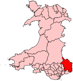
Monmouth is a county constituency of the House of Commons of the Parliament of the United Kingdom. The seat was created for the 1918 general election. Since 2005 the Member of Parliament (MP) has been David Davies of the Conservative Party.
Blackwood is a town, community and an electoral ward on the Sirhowy River in the South Wales Valleys administered as part of Caerphilly County Borough. It is located within the historic county of Monmouthshire.

Rhymney Valley was one of six local government districts in Mid Glamorgan from 1974 to 1996.

Bedwas, Trethomas and Machen is a community and an electoral ward in the county borough of Caerphilly, constituting the villages of Machen, Trethomas, Bedwas, and Upper and Lower Graig-y-Rhacca. It lies in the Caerphilly Basin in the shadow of Mynydd y Grug and Mynydd Machen. All villages in the area grew as a result of the coal mining industry, which carries its legacy on today.

Bedwellty was a parish and urban district in Monmouthshire, South Wales, until 1974.
Bedwellty was a county constituency in Monmouthshire which returned one Member of Parliament (MP) to the House of Commons of the Parliament of the United Kingdom from 1918 until it was abolished for the 1983 general election.

Islwyn Borough Transport was a Welsh bus operator providing services around Blackwood, Caerphilly, and surrounding towns in the former Borough of Islwyn between 1974 and 2010.

Gwent is a preserved county and former local government county in southeast Wales. A county of Gwent was formed on 1 April 1974, under the Local Government Act 1972; it was named after the ancient Kingdom of Gwent. The authority was a successor to both the administrative county of Monmouthshire and the county borough of Newport. In forming the county of Gwent the act explicitly resolved the previously somewhat ambiguous status of the latter two authorities, in terms of whether they were a part of Wales or England.
Western Monmouthshire was a parliamentary constituency in Monmouthshire. It returned one Member of Parliament (MP) to the House of Commons of the Parliament of the United Kingdom.
Penmain or Penmaen is a hamlet and community in Caerphilly county borough, south Wales, within the historic boundaries of Monmouthshire. It is situated in the Sirhowy valley, 3 miles (4.8 km) East of Blackwood. It is contiguous with, if not completely encompassed by, the larger village of Oakdale, which forms most of the community urban area.
The history of local government in Wales in a recognisably modern form emerged during the late 19th century. Administrative counties and county boroughs were first established in Wales in 1889. Urban and rural districts were formed in 1894. These were replaced in 1974 by a two-tier authority system across the country comprising eight counties and, within them, thirty-seven districts. This system was itself replaced by the introduction of 22 single-tier authorities in 1996.

Ynysddu is a small village and community in the Sirhowy valley of south-east Wales. It is part of the district of Caerphilly within the historic boundaries of Monmouthshire. It lies between to Cwmfelinfach and Wyllie, 4.3 miles (6.9 km) north of the town of Risca and 4 miles (6.4 km) south of the market town of Blackwood. It is about 10 minutes by road from the M4 motorway and 20 minutes from the Second Severn Crossing. The population in 2008 was 2,905, increasing to 3,948 at the 2011 Census.
References
- ↑ Kelly's Directory of Monmouthshire, 1901
- ↑ County Census Report, Monmouthshire, 1901
- ↑ Local Government Act 1972, Schedule 4