Mölbling

Last updated
Mölbling
Sankt Stefan am Krappfeld - Kirche.JPG
Wappen at moelbling.png
Coat of arms
Austria adm location map.svg
Red pog.svg
Mölbling
Location within Austria
Coordinates: 46°52′N14°27′E / 46.867°N 14.450°E / 46.867; 14.450 Coordinates: 46°52′N14°27′E / 46.867°N 14.450°E / 46.867; 14.450
Country Austria
State Carinthia
District Sankt Veit an der Glan
Government
   Mayor Franz Rainer (FPK)
Area
[1]
  Total48.95 km2 (18.90 sq mi)
Elevation
585 m (1,919 ft)
Population
(2018-01-01) [2]
  Total1,315
  Density27/km2 (70/sq mi)
Time zone UTC+1 (CET)
  Summer (DST) UTC+2 (CEST)
Postal code
9330. 9312, 9300, 9341
Area code 04262
Website www.moelbling.at

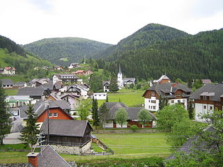
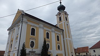
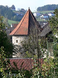
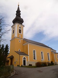
Mölbling (Slovene : Molnek) is a municipality on the Gurk River in the district of Sankt Veit an der Glan in the Austrian state of Carinthia.

Slovene language language spoken in Slovenia

Slovene or Slovenian belongs to the group of South Slavic languages. It is spoken by approximately 2.5 million speakers worldwide, the majority of whom live in Slovenia. It is the first language of about 2.1 million Slovenian people and is one of the 24 official and working languages of the European Union.

Gurk (river) river in Austria

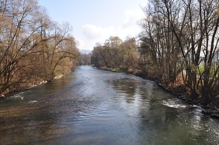
The Gurk is a river in the Austrian state of Carinthia, a left tributary of the Drava. With a length of 156 km (97 mi), it is the longest river running entirely within Carinthia. The river basin covers about 27% of the state's territory.

Austria Federal republic in Central Europe

Austria, officially the Republic of Austria, is a country in Central Europe comprising 9 federated states. Its capital, largest city and one of nine states is Vienna. Austria has an area of 83,879 km2 (32,386 sq mi), a population of nearly 9 million people and a nominal GDP of $477 billion. It is bordered by the Czech Republic and Germany to the north, Hungary and Slovakia to the east, Slovenia and Italy to the south, and Switzerland and Liechtenstein to the west. The terrain is highly mountainous, lying within the Alps; only 32% of the country is below 500 m (1,640 ft), and its highest point is 3,798 m (12,461 ft). The majority of the population speaks local Bavarian dialects as their native language, and German in its standard form is the country's official language. Other regional languages are Hungarian, Burgenland Croatian, and Slovene.

Contents

Geography

Mölbling lies about 27 km northeast of Klagenfurt. The Gurk runs through the eastern edge of the municipality.

Klagenfurt Place in Carinthia, Austria

Klagenfurt am Wörthersee is the capital of the federal state of Carinthia in Austria. With a population of 100,772, it is the sixth-largest city in the country. The city is the bishop's seat of the Roman Catholic Diocese of Gurk-Klagenfurt and home to the University of Klagenfurt.

The commune comprises the Katastralgemeinden of Dielach, Gunzenberg, Meiselding, Rabing, and Rastenfeld.

Politics

Seats in the municipal assembly (Gemeinderat) as of 2009 elections:

Alliance for the Future of Austria political party

The Alliance for the Future of Austria is a right-wing populist and national conservative political party in Austria.

Social Democratic Party of Austria one of the oldest political parties in Austria

The Social Democratic Party of Austria is a social-democratic political party in Austria that is, along with the People's Party, one of the country's two traditional major parties.

Austrian Peoples Party conservative political party in Austria

The Austrian People's Party is a conservative Christian-democratic political party in Austria. A successor to the Christian Social Party of the late 19th and early 20th centuries, it was founded immediately following the reestablishment of the Republic of Austria in 1945 and since then has been one of the two largest Austrian political parties with the Social Democratic Party of Austria (SPÖ). In federal governance, the ÖVP has spent most of the postwar era in a grand coalition with the SPÖ. Most recently, it has been junior partner in a coalition government with the SPÖ since 2007. However, the ÖVP won the 2017 election, having the greatest number of seats and formed a coalition with the far-right Freedom Party of Austria (FPÖ). Its chairman Sebastian Kurz is the youngest Chancellor in Austrian history.

Personalities

In 1893 the Austrian chemist Carl Auer von Welsbach acquired Rastenfeld Castle as his private residence, where he died in 1929.

Carl Auer von Welsbach Austrian scientist and inventor

Carl Auer von Welsbach, also known as Carl Auer, Freiherr von Welsbach was an Austrian scientist and inventor, who had a talent not only for discovering advances, but also for turning them into commercially successful products. He is particularly well known for his work on rare-earth elements, which led to the development of the ferro rod used in modern lighters, the gas mantle, which brought light to the streets of Europe in the late 19th century, and for the development of the metal-filament light bulb.

Related Research Articles

Gurk, Carinthia Place in Carinthia, Austria

Gurk is an Austrian market town and former episcopal see in the District of Sankt Veit an der Glan, Carinthia.

Straßburg, Austria Place in Carinthia, Austria

Straßburg is a town in the district of Sankt Veit an der Glan in Carinthia, Austria.

Albeck, Carinthia Place in Carinthia, Austria

Albeck is a municipality in the district of Feldkirchen in the Austrian state of Carinthia.

Gnesau Place in Carinthia, Austria

Gnesau is a town in the district of Feldkirchen in the Austrian state of Carinthia.

Reichenau, Carinthia Place in Carinthia, Austria

Reichenau is a municipality in the district of Feldkirchen in the Austrian state of Carinthia.

Steuerberg Place in Carinthia, Austria

Steuerberg is a town in the district of Feldkirchen in the Austrian state of Carinthia.

Ebenthal Place in Carinthia, Austria

Ebenthal is a town in the district of Klagenfurt-Land in the Austrian state of Carinthia.

Brückl Place in Carinthia, Austria

Brückl is a town in the district of Sankt Veit an der Glan in the Austrian state of Carinthia.

Deutsch-Griffen Place in Carinthia, Austria

Deutsch-Griffen is a municipality in the district of Sankt Veit an der Glan in Austrian state of Carinthia.

Glödnitz Place in Carinthia, Austria

Glödnitz is a municipality in the district of Sankt Veit an der Glan in the Austrian state of Carinthia.

Sankt Georgen am Längsee Place in Carinthia, Austria

Sankt Georgen am Längsee is a municipality in the district of Sankt Veit an der Glan in Carinthia, Austria.

Mühldorf, Carinthia Place in Carinthia, Austria

Mühldorf is a municipality in the district of Spittal an der Drau in the Austrian state of Carinthia.

Drösing Place in Lower Austria, Austria

Drösing is a town in the district of Gänserndorf in the Austrian state of Lower Austria.

Werfenweng Place in Salzburg, Austria

Werfenweng is a municipality in the St. Johann im Pongau district in the state of Salzburg in Austria.

Neukirchen an der Enknach Place in Upper Austria, Austria

Neukirchen an der Enknach is a municipality in the district of Braunau am Inn in the Austrian state of Upper Austria.

Hofkirchen an der Trattnach Place in Upper Austria, Austria

Hofkirchen an der Trattnach is a municipality in the district of Grieskirchen in the Austrian state of Upper Austria.

Wallern an der Trattnach Place in Upper Austria, Austria

Wallern an der Trattnach is a municipality in the district of Grieskirchen in the Austrian state of Upper Austria.

Haslach an der Mühl Place in Upper Austria, Austria

Haslach an der Mühl is a municipality in the district of Rohrbach in the Austrian state of Upper Austria.

Altschwendt Place in Upper Austria, Austria

Altschwendt is a municipality in the district of Schärding in the Austrian state of Upper Austria.

Engelhartszell an der Donau Place in Upper Austria, Austria

Engelhartszell an der Donau is a municipality in the district of Schärding in the Austrian state of Upper Austria.

References

  1. "Dauersiedlungsraum der Gemeinden Politischen Bezirke und Bundesländer - Gebietsstand 1.1.2018". Statistics Austria. Retrieved 10 March 2019.
  2. "Einwohnerzahl 1.1.2018 nach Gemeinden mit Status, Gebietsstand 1.1.2018". Statistics Austria. Retrieved 9 March 2019.