The rusty-spotted cat is one of the cat family's smallest members, of which historical records are known only from India and Sri Lanka. In 2012, it was also recorded in the western Terai of Nepal. Since 2016, the global wild population is listed as Near Threatened on the IUCN Red List as it is fragmented and affected by loss and destruction of its prime habitat, deciduous forests.
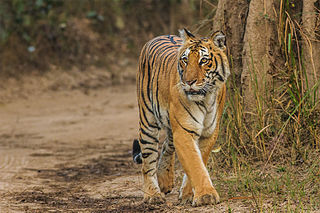
Jim Corbett National Park is a national park in India located in the Nainital district of Uttarakhand state. The first national park in India, it was established in 1936 during the British Raj and named Hailey National Park after William Malcolm Hailey, a governor of the United Provinces in which it was then located. In 1956, nearly a decade after India's independence, it was renamed Corbett National Park after the hunter and naturalist Jim Corbett, who had played a leading role in its establishment and had died the year before. The park was the first to come under the Project Tiger initiative.

The Terai or Tarai is a lowland region in northern India and southern Nepal that lies south of the outer foothills of the Himalayas, the Sivalik Hills, and north of the Indo-Gangetic Plain. This lowland belt is characterised by tall grasslands, scrub savannah, sal forests and clay rich swamps. In northern India, the Terai spreads from the Yamuna River eastward across Haryana, Uttarakhand, Uttar Pradesh, Bihar and West Bengal. The Terai is part of the Terai-Duar savanna and grasslands ecoregion. The corresponding lowland region in West Bengal, Bangladesh, Bhutan and Assam in the Brahmaputra River basin is called 'Dooars'. In Nepal, the term is applied to the part of the country situated north of the Indo-Gangetic Plain. Nepal's Terai stretches over 33,998.8 km2 (13,127.0 sq mi), about 23.1% of Nepal's land area, and lies at an elevation of between 67 and 300 m. The region comprises more than 50 wetlands. North of the Terai rises the Bhabar, a narrow but continuous belt of forest about 8–12 km (5.0–7.5 mi) wide.

Chitwan National Park is the first national park of Nepal. It was established in 1973 and was granted the status of a World Heritage Site in 1984. It covers an area of 952.63 km2 (367.81 sq mi) and it is located in the subtropical Inner Terai lowlands of south-central Nepal in the districts of Nawalpur, Parasi, Chitwan and Makwanpur. In altitude it ranges from about 100 m (330 ft) in the river valleys to 815 m (2,674 ft) in the Sivalik Hills.

The Dooars or Duars are the alluvial floodplains in eastern-northeastern India that lie south of the outer foothills of the Himalayas and north of the Brahmaputra River basin. This region is about 30 km (19 mi) wide and stretches over about 350 km (220 mi) from the Teesta River in West Bengal to the Dhansiri River in Assam. The region forms the gateway to Bhutan. It is part of the Terai-Duar savanna and grasslands ecoregion.
There are four categories of protected areas in India, constituted under the Wildlife Protection Act, 1972. Tiger reserves consist of areas under national parks and wildlife sanctuaries. There are 52 tiger reserves in India. As of May 2012, the protected areas of India cover 156,700 square kilometres (60,500 sq mi), roughly 4.95% of the total surface area.

Gorumara National Park is a National Park in northern West Bengal, India. Located in the Dooars region of the Himalayan foothills, it is a medium-sized park with grasslands and forests. Gorumara National Park was established in 1992. It is primarily known for its population of Indian rhinoceros. The park has been declared as the best among the protected areas in India by the Ministry of Environment and Forests for the year 2009.

Buxa Tiger Reserve is a Tiger reserve and National park in northern West Bengal, India, covering an area of 760 km2 (290 sq mi). In altitude, it ranges from 60 m (200 ft) in the Gangetic Plains to 1,750 m (5,740 ft) bordering the Himalayas in the north. At least 284 bird species inhabit the reserve. Mammals present include Asian elephant, gaur, Sambar deer, clouded leopard, Indian leopard.

Valmiki National Park is a Tiger Reserve in the West Champaran District of Bihar, India. It is the only national park in Bihar. Valmiki Tiger Reserve covers 898.45 km2 (346.89 sq mi), which is 17.4% of the total geographical area of the district. As of 2018, there were 40 tigers in the Reserve.

The Terai–Duar savanna and grasslands is a narrow lowland ecoregion at the base of the Himalayas, about 25 km (16 mi) wide, and a continuation of the Indo-Gangetic Plain in India, Nepal and Bhutan. It is colloquially called Terai in the Ganges Basin east to Nepal, then Dooars in West Bengal, Bhutan and Assam east to the Brahmaputra River. It harbours the world's tallest grasslands, which are the most threatened and rare worldwide.
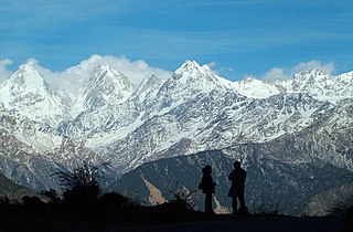
Askot Musk Deer Sanctuary is located 54 km (34 mi) from Pithoragarh near Askot in Uttarakhand state of India. This sanctuary has been set up primarily with the object of conserving the musk deer (Moschus leucogaster) and its habitat. Intensive efforts have been initiated to conserve this rare species. Other mammals found in this sanctuary include the Bengal tiger, Indian leopard, Himalayan jungle cat, civet, barking deer, serow, goral and Himalayan brown bear. Many species of high altitude birds are also found in this sanctuary.

The Upper Gangetic Plains moist deciduous forests is a tropical and subtropical moist broadleaf forests ecoregion of northern India.

Uttar Pradesh is India's fourth largest state by land area, and most populous state, located in the north-central part of the country. It spreads over a large area, and the plains of the state are quite distinctly different from the high mountains in the north. The climate of this state can also vary widely - primarily due to it being far from the moderating effect of the sea and the occasional cold air arising due to western disturbances.
Conservation Areas in India refer to well-demarcated large geographical entities with an established conservation plan, and were part of a joint Indo-US project on "landscape management and protection". The project ran from 1996 to 2002. These areas are home to many Conservation reliant species.

The Katarniaghat Wildlife Sanctuary is a protected area in the Upper Gangetic plain, near Bahraich city in Bahraich district of Uttar Pradesh, India and covers an area of 400.6 km2 (154.7 sq mi) in the Terai of the Bahraich district. In 1987, it was brought under the purview of the ‘Project Tiger’, and together with the Kishanpur Wildlife Sanctuary and the Dudhwa National Park it forms the Dudhwa Tiger Reserve. It was established in 1975.
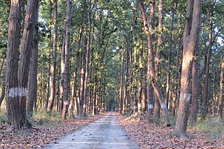
Pilibhit Tiger Reserve is located in Pilibhit district of Uttar Pradesh and was notified as a tiger reserve in 2014. It forms part of the Terai Arc Landscape in the upper Gangetic Plain along the India-Nepal border. The habitat is characterized by sal forests, tall grasslands and swamp maintained by periodic flooding from rivers. The Sharda Sagar Dam extending up to a length of 22 km (14 mi) is on the boundary of the reserve.

Shuklaphanta National Park is a national park in the Terai of the Far-Western Region, Nepal, covering 305 km2 (118 sq mi) of open grasslands, forests, riverbeds and tropical wetlands at an elevation of 174 to 1,386 m. It is bounded by the Mahakali river in the west and south. A small part extends north of the Mahendra Highway to create a wildlife corridor for seasonal migration of wildlife into the Sivalik Hills. It was gazetted in 1976 as Royal Shuklaphanta Wildlife Reserve and was enlarged to its presence size in the late 1980s. A buffer zone of 243.5 km2 (94.0 sq mi) was added in 2004. It receives a mean annual rainfall of 1,579 mm (62.2 in) and harbours 700 floral, 456 bird, 56 reptile and 15 amphibian species.

Sathyamangalam Tiger Reserve is a protected area and tiger reserve in the Eastern Ghats in the Erode District of the Indian state of Tamil Nadu. It has a tiger population of 83 individuals and a leopard population of 111 individuals according to the 2019 census.
Govind Pashu Vihar National Park and Wildlife Sanctuary is a national park in Uttarakhand, India established initially as a wildlife sanctuary in 1955, and was later converted into a national park. It is named after a prominent Indian freedom fighter and politician Govind Ballabh Pant, who became Home Minister in 1955 and is remembered for his achievement in establishing Hindi as an official language.
Terai Arc Landscape (TAL) is composed of 14 Indian and Nepalese trans-border protected ecosystems of the Terai and nearby foothills of the Himalayas. and encompassing 14 protected areas of Nepal and India. The area spans approximately 12.3 million acres and includes Nepal's Bagmati River to the east and India's Yamuna River to the west. The TAL is home to many endangered mammals including the Bengal tiger, the Indian rhinoceros, the gaur, the wild Asian elephant, the hispid hare, the sloth bear, the South Asian river dolphin and the chital, as well as over 500 species of birds, many endangered. Examples of birds are the endangered Bengal florican, the sarus crane, and the black stork.