Related Research Articles
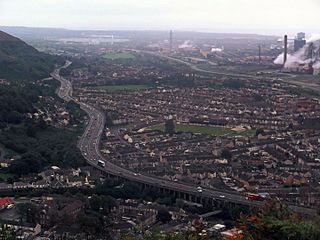
Port Talbot is a town and community in the county borough of Neath Port Talbot, Wales, situated on the east side of Swansea Bay, approximately eight miles from Swansea. The Port Talbot Steelworks covers a large area of land which dominates the south east of the town and is one of the biggest steelworks in the world but has been under threat of closure since the 1980s. The population was 37,276 in 2011.

The River Afan is a river in Wales whose valley formed the territory of the medieval Lords of Afan. The Afan Valley encompasses the upper reaches of the river. The valley is traversed by the A4107 road. Settlements in the area include Cwmafan, Pontrhydyfen and Cymmer. The town of Aberavon, whose name in Welsh Aberafan means 'mouth of the Afan', grew up on the banks of the river and was later subsumed by the town of Port Talbot.

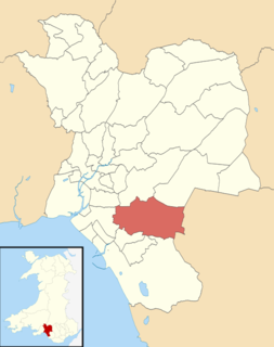
Neath Port Talbot is a county borough in the south-west of Wales. Its principal towns are Neath, Port Talbot, Briton Ferry and Pontardawe. The county borough borders Bridgend County Borough and Rhondda Cynon Taf to the east, Powys and Carmarthenshire to the north; and Swansea to the west.

Aberavon is a town and community in Neath Port Talbot county borough, Wales. The town derived its name from being near the mouth of the river Afan, which also gave its name to a medieval lordship. Today it is essentially a district of Port Talbot, covering the central and south western part of the town. Aberavon is also the name of the nearby Blue Flag beach and the parish covering the same area.
Margam is a suburb and community of Port Talbot in the Welsh county borough of Neath Port Talbot, Wales, close to junction 39 of the M4 motorway. The community had a population of 3,017 in 2011; the built up area being larger and extending into Taibach community.

Margam Country Park is a country park estate in Wales, of around 850 acres (3.4 km²). It is situated in Margam, about 2 miles (3 km) from Port Talbot in south Wales. It was once owned by the Mansel Talbot family and is now owned and administered by the local council, Neath Port Talbot County Borough Council. Situated within the park are three notable buildings: Margam Abbey, a Cistercian monastery; Margam Castle, a neo-Gothic country house that was once the seat of the Mansel Talbot family; and the 18th-century Orangery.
Taibach or Tai-bach is a suburban district, community, of Port Talbot, Wales. It is a settlement centered on the main A48 road, sandwiched between the river Ffrwdwyllt and Margam. Parts of Margam are within the community and electoral ward boundaries.
Coedffranc Central is an electoral ward of Neath Port Talbot county borough, Wales. Coedffranc Central is a part of the Coedffranc community and falls within the parliamentary constituency of Aberavon.
Bryn and Cwmavon is an electoral ward of Neath Port Talbot county borough, south Wales. The electoral ward comprises the parishes of Bryn and Cwmavon.
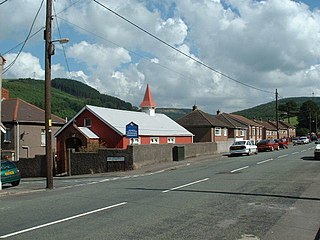
Goytre is a village near the town of Port Talbot, Wales.
The electoral ward of Port Talbot in Neath Port Talbot county borough covers the town centre of Port Talbot and the district of Pen-y-cae. The rest of the ward to the east consists of grassland and woodland. The electoral ward is coterminous with the Port Talbot community boundaries.
Margam Moors is a community of Neath Port Talbot county borough, Wales. Together with the community of Margam, it forms the Margam electoral ward.

The Afon Clun is a 14-mile (23 km) long tributary of the River Ely, in the counties of Cardiff and Rhondda Cynon Taf, Wales. Its bedrock is predominantly of sandstone. Beginning on the western slope of The Garth the river is fast-flowing, in clear shallow water with a hard substrate, flowing to the south of Llantrisant and generally west to its confluence with the River Ely at Pontyclun, falling 715 feet (218 m) over its course.
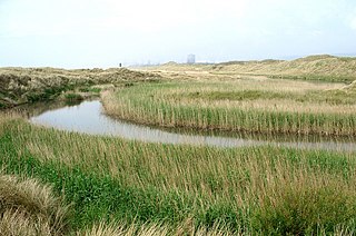
The River Kenfig is a river in Wales, straddling the county boroughs of Neath Port Talbot and Bridgend. It is approximately 18 kilometres long.
Hirfynydd is a 481-metre-high hill in Neath Port Talbot county borough in South Wales. A Roman road, Sarn Helen, runs along its entire northeast–southwest ridge-line, a route followed by a modern-day byway. To its west is Cwm Dulais and to its southeast is the Vale of Neath. The northern end of the ridge falls away to a broad upland vale containing the Afon Pyrddin and beyond which is the Brecon Beacons National Park.

Mynydd-y-Gaer is a hill that sits on the boundaries between the South Wales communities of Baglan, Cwmavon and Briton Ferry,, all within Neath Port Talbot county borough. The summit, at 314 m (1,030 ft), has grassland fields subdivided by dry stone walls. Foel Fynyddau lies 2 km to east. To the south is the coastal plain of the Bristol Channel. To the West is the Vale of Neath. To the north is the Crythan Brook and the town of Neath. It has numerous prehistoric monuments, and evidence of occupation in medieval times, as well as 19th and 20th century coalmining.
Foel Chwern is a Round cairn on the edge of the high plateau east of the Neath valley, and near the summit of Craig y Llyn. The headwaters of the River Rhondda are to the south-west. It is a burial monument dating to the Bronze Age, and is sited on the edge of a steep scarp slope, with a wide field of view to the north. The long distance footpath Coed Morgannwg Way runs close by the cairn. Conifer plantations of the Rheola Forest surround the site.
Groes was a village south of Port Talbot in the county of Glamorgan, Wales. It was demolished in 1976 to make way for Junction 39 of the new M4 motorway.
Cwm Clydach is a community and electoral ward to the northwest of Tonypandy in Rhondda Cynon Taf, Wales. The community and ward covers the valley of the Nant Clydach, which includes the cojoined villages of Clydach Vale and Blaenclydach.
References
- 1 2 Clarke Bond. Report no WB02944/SFCA: Neath Port Talbot CBC Strategic Flood Consequence Assessment in Support of the Local Development Plan (LDP) (PDF). Community Archives Wales. p. 15. Retrieved 4 May 2012.
- ↑ "Bridge over Ffrwdwyllt (1904)". Community Archives Wales. Retrieved 4 May 2012.
- ↑ An Inventory of the Ancient Monuments in Glamorgan Vol. 3 pt. 2: Secular Non-defensive Monuments. RCAHMW. 1982. pp. 274–277.
- ↑ "Mynydd Margam Historic Landscape - Character Areas". Historic Landscape Characterisation. Glamorgan-Gwent Archaeological Trust. Retrieved 17 April 2016.