Nareli Jain Temple

Last updated

Nareli Jain Temple
Nareli Ajmer.JPG
Shri Gyanodaya Tirth Kshetra
Religion
Affiliation Jainism
Sect Digambara
Deity Rishabhanatha
Festivals Mahavir Jayanti
Location
LocationNareli, Ajmer, Rajasthan, India
India Rajasthan location map.svg
In-jain.svg
Location within Rajasthan
Geographic coordinates 26°27′32″N74°42′16″E / 26.45889°N 74.70444°E / 26.45889; 74.70444
Architecture
CreatorAshok Patni, Dinnath Jain, RK Marbels
Date established1994
Temple(s)25

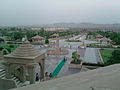
Nareli Jain Temple or Shri Gyanodaya Tirth Kshetra, is a new Jain temple located on the outskirts of Ajmer 7 kilometers from the city center and 128 kilometers west of Jaipur on the main national highway 8. [1]

Contents

History

Ashok Patni of RK Marbles constructed this temple. [2] The temple is situated on the Aravali mountain range. [3] The temple was estimated to cost around Rupees 50 crore, but ended up costing close to Rupees 100 crore. The main temple was built by Dinnath ji Jain after him the construction is completed by Deepak Jain and his family [4]

About temple

The temple is an important Jain pilgrimage site for Digambar Jains. The temple complex consists 24 small Jinalaya for 24 tirthankars. [5]

Gavin Thomas, in his book, "The Rough Guide to Rajasthan, Delhi & Agra" (2010, p. 257), writes on Nareli Jain Temple: [6]

"There's another striking monument to the Jain faith some 7km southeast of Ajmer on the Jaipur bypass, the angular modern Nareli Temple, a striking edifice mixing traditional and contemporary architectural styles to somewhat quirky effect, with 23 further miniature temples lined up on the hill above."

The other Jain temple that the author talks about is the Ajmer Jain Temple.

Transportation

It lies on the main national highway no. 8 which is a 6 lane expressway from Jaipur onwards and connects the Delhi-Ajmer-Mumbai. Autos and taxis are available from Ajmer and nearby towns.

Nearest railway station is Ajmer junction which is an important railway junction with broad gauge lines.

Presently the nearest airport is the Kishangarh Airport but it has limited connectivity. The next best option is Jaipur International Airport, which is about 125 km away, with daily flights to the major cities in India and certain international flights.

See also

Related Research Articles

<span class="mw-page-title-main">Ajmer</span> City in Rajasthan, India

Ajmerpronounced [ədʒmeːr](listen) is one of the major and oldest cities in the Indian state of Rajasthan and the centre of the eponymous Ajmer District. It is located at the centre of Rajasthan. It is also known as heart of Rajasthan. The city was established as "Ajayameru" by a Chahamana ruler, either Ajayaraja I or Ajayaraja II, and served as their capital until the 12th century CE.

<span class="mw-page-title-main">Rajasthan</span> State in Northwestern India

Rajasthan is a state in northern India. It covers 342,239 square kilometres (132,139 sq mi) or 10.4 per cent of India's total geographical area. It is the largest Indian state by area and the seventh largest by population. It is on India's northwestern side, where it comprises most of the wide and inhospitable Thar Desert and shares a border with the Pakistani provinces of Punjab to the northwest and Sindh to the west, along the Sutlej-Indus River valley. It is bordered by five other Indian states: Punjab to the north; Haryana and Uttar Pradesh to the northeast; Madhya Pradesh to the southeast; and Gujarat to the southwest. Its geographical location is 23°.3' to 30°.12' North latitude and 69°.30' to 78°.17' East longitude, with the Tropic of Cancer passing through its southernmost tip.

<span class="mw-page-title-main">Jaipur</span> Capital of Rajasthan, India

Jaipur, formerly Jeypore, is the capital and largest city of the Indian state of Rajasthan. As of 2011, the city had a population of 3.1 million, making it the tenth most populous city in the country. Jaipur is also known as the Pink City, due to the dominant colour scheme of its buildings. It is also known as the Paris of India, and C. V. Raman called it the Island of Glory. It is located 268 km from the national capital New Delhi. Jaipur was founded in 1727 by the Kachhwaha Rajput ruler Jai Singh II, the ruler of Amer, after whom the city is named. It was one of the earliest planned cities of modern India, designed by Vidyadhar Bhattacharya. During the British Colonial period, the city served as the capital of Jaipur State. After independence in 1947, Jaipur was made the capital of the newly formed state of Rajasthan.

<span class="mw-page-title-main">Shikharji</span> Jain pilgrimage centre and hill forest in Jharkhand, India

Shikharji, also known as Sammed or Sammet Shikharji, is one of the Holiest pilgrimage sites for Jains, in Giridih district, Jharkhand. It is located on Parasnath hill, the highest mountain in the state of Jharkhand. It is the most important Jain Tirtha, for it is the place where twenty of the twenty-four Jain tirthankaras along with many other monks attained Moksha. It is one of the five principal pilgrimage destinations along with Girnar, Pawapuri, Champapuri, Dilwara, Palitana and Ashtapad Kailash.

<span class="mw-page-title-main">Bhilwara</span> City in Rajasthan, India

Bhilwara is a city and administrative headquarters in Bhilwara district of the Mewar region of Rajasthan, India. It has been termed as 'Textile city'.

<span class="mw-page-title-main">Chittorgarh</span> City in Rajasthan, India

Chittorgarhpronunciation  is a major city in Rajasthan state of western India. It lies on the Berach River, a tributary of the Banas, and is the administrative headquarters of Chittorgarh District. It was a major stronghold of the Rajput State of Medapata. The city of Chittorgarh is located on the banks of river Gambhiri and Berach.

<span class="mw-page-title-main">Hindaun</span> City in Rajasthan, India

Hindaun is a city and municipality, near city of Karauli in Karauli district, Rajasthan, India. It has a population of 105690 and is governed by a municipal council.

Dausa is a city and administrative headquarters of Dausa district in the state of Rajasthan, India. It is 55 km from Jaipur, 240 km from Delhi and located on Jaipur-Agra National Highway (NH-21).

<span class="mw-page-title-main">Sawai Madhopur</span> City in Rajasthan, India

Sawai Madhopur is a city and Municipal Council in the Sawai Madhopur District in Rajasthan state, India. It is the administrative headquarters of Sawai Madhopur District of Rajasthan. Ranthambore National Park which is 7 km from the railway station and Ranthambore Fort, a UNESCO World Heritage Site are located near Sawai Madhopur.

Ambaji (Ambājī) is a census town in Banaskantha district in the state of Gujarat, India. It is known for its historical connections with sites of cultural heritage.

<span class="mw-page-title-main">Makrana</span> City in Rajasthan, India

Makrana is an urban city located at the centre of Rajasthan in Kuchaman City District. It also served as a tehsil headquarters, with 136 villages under its jurisdiction thus making it the largest tehsil in the district. The biggest village of Makrana tehsil by area is Modicharna. Makrana is 110 km (68 mi) west of Jaipur and 190 km (120 mi) north-east of Jodhpur. Makrana is known for the part it has played in building the Taj Mahal by supplying marble, craftsmen and stonemasons to build the iconic UNESCO world heritage centre. It is one of the developing cities in the state. The marble from the town Makrana which is known as Makrana Marble, gets the GHSR status from the IUGS.

<span class="mw-page-title-main">Nakoda, Rajasthan</span> Village in Rajasthan, India

Nakoda Mewanagar is a village in the Barmer District of Indian state of Rajasthan. The village name is Mewanagar in the Rajasthan state Government records.

Jobner is a tehsil headquarter and one of the oldest municipalities in Jaipur district in the Indian state of Rajasthan.

<span class="mw-page-title-main">Tourism in Rajasthan</span>

Rajasthan is one of the most popular tourist destinations in India, for both domestic and international tourists. Rajasthan attracts tourists for its historical forts, palaces, art and culture with its slogan "Padharo Mhare Desh " Jaipur, is also known as Pink City, is a very popular tourist destination, being the capital of Rajasthan and a part of the Golden Triangle. The Walled City of Jaipur is a UNESCO World Heritage Site and is only the second Indian city to be recognized, after Ahmedabad.

Jaswantgarh is a town that comes in Ladnun tehsil of Nagaur district under Ajmer Division of Rajasthan, India. situated about 210 km from Jaipur and around 35 km from Salasar. The headquarter Nagaur district is just 96km away. The distance between India's capital New Delhi from Jaswantgarh is 380km. Nearest airport is Jaipur International Airport(Sanganer). Jaswantgarh is also known as "Land of Bhamashahs" includes well known billionaire plastic tycoon non-executive director and chairman of Supreme Industries and Taparia tools named Bajrang Lal Taparia and Toshniwals.

<span class="mw-page-title-main">Ajmer Jain temple</span> Temple in Rajasthan, India

The Ajmer Jain temple, also known as Soniji Ki Nasiyan, is a Jain temple known for its architecture. It was built in the late nineteenth century. The main chamber, known as the Swarna Nagari "City of Gold", has several gold-plated wooden figures, depicting several figures in the Jain religion. This golden chamber of the temple uses 1000 kg of gold to carve out a depiction of Ayodhya.

<span class="mw-page-title-main">Sawai Madhopur Junction railway station</span> Railway station in Rajasthan, India

Sawai Madhopur Junction Railway Station is a major railway station on New Delhi–Mumbai main line and Jaipur–Mumbai rail line of the West Central Railway zone network. It is very well connected to Gangapur city, Bayana junction, Bharatpur, Mathura, Kanpur Central, Delhi, Hazarat Nizamuddin, Bikaner, Chittaurgarh.

The Ring Road is a 150 kilometre, 6-lane ring road encircling the city of Jaipur, Rajasthan, India. It is built by Jaipur Development Authority (JDA). The expressway is designed for speeds up to 120 km/h. Construction of the Ring Road around Jaipur was conceived by PWD in December 2000 on BOT basis. In Phase I & II, a road with a length of 47 km will be constructed in the south of Jaipur, connecting Ajmer Road, Tonk Road and Agra Road. In Phase III, a road with a length of 97.75 km will be constructed in the northern part of Jaipur and will connect Agra Road, Delhi Road, Sikar Road and Ajmer Road.

Nasopur is a village in Kotkasim, Tehsil Alwar district, in the Indian state of Rajasthan. It is located around 75 km south of Delhi, 75 km north of Alwar, and about 200 km north of Jaipur, the capital of Rajasthan. Nasopur is part of Greater Bhiwadi and National Capital Region (NCR).

Nimbi Jodha is a town in Ladnu, Nagaur District, Rajasthan, India. It belongs to Ajmer Division. It is located 75 km east of the district headquarters, Nagaur, and 51 km from Salasar Balaji.

References

  1. "Sight Seeing". Ajmer.nic.in. Archived from the original on 30 May 2012. Retrieved 19 May 2012.
  2. "Gyanodaya Tirh Chetra Nareli Ajmer | Religious Place | Ajmer". IndiaOnAPage. Retrieved 19 May 2012.
  3. "अरावली पर्वतमाला पर ज्ञानोदय तीर्थ, श्रद्धालुओं के आकर्षण का केंद्र". dainikbhaskar. Retrieved 14 April 2016.
  4. "Enlightenment completed the pilgrimage area - www.bhaskar.com". dainikbhaskar. Retrieved 14 April 2016.
  5. "Ajmer tourism". Rajasthan Tourism Development Corporation . Retrieved 13 June 2021.
  6. Thomas, Gavin (20 September 2010). The Rough Guide to Rajasthan, Delhi & Agra - Gavin Thomas - Google Books. Penguin. ISBN   9781405386883 . Retrieved 19 May 2012.