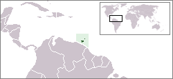
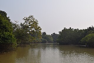
The Nariva Swamp on the mouth of the Ortoire River in Trinidad.A physical relief map of Trinidad showing the Nariva Plain and Nariva Swamp in the southeast.
The Nariva Swamp is the largest freshwaterwetland in Trinidad and Tobago and has been designated a Wetland of International Importance under the Ramsar Convention. The swamp is located on the east coast of Trinidad, immediately inland from the Manzanilla Bay through Biche and covers over 60 square kilometres (23mi2). The Nariva Swamp is extremely biodiverse. It is home to 45 mammal species, 39 reptile species, 33 fish species, 204 bird species, 19 frog species, 213 insect species and 15 mollusc species. All this contained in just 60 square kilometers.
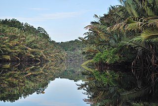
Four major wetland vegetation types[4] occur in the Nariva Swamp - mangrove swamp forest, palm forest, swamp wood, and freshwater marsh.
Virus research
Virus Laboratory Field Assistant, Nariva Swamp, Trinidad. 1959
The Trinidad Regional Virus Lab (TRVL) (now CAREC) conducted research on arboviruses there in past decades. One portion of the swamp, the Bush Bush Wildlife Sanctuary is historically important as a field site for the Trinidad Regional Virus Laboratory - now part of the Caribbean Epidemiology Center (Carec), which played a key role in the study of tropical mosquito-borne diseases.
Conservation
The Nariva Swamp, 6,234 hectares, was declared to be a forest reserve in 1954. The Bush Bush section of the Nariva Swamp 1,408 hectares (3,480 acres) is an area of high ground that was declared as a wildlife sanctuary in 1968, and a prohibited area in 1989 by Dr. Keith Rowley (legal notice no 78 by then Minister of Agriculture, Land and Marine Resources). The site was thus reserved as a local and international research centre, and in theory no hunting or harvesting was allowed on the site.
The Nariva Swamp is protected by 3 main pieces of legislation: the Forests Act, Chapter 66: 01; the Conservation of Wildlife Act, Chapter 67: 01; the State Lands Act, Chapter 57: 01. Offences taken to court are usually related to wildlife poaching and tree felling. This was not entirely successful and encroachment by squatters was ongoing (Ramsar, 1996). The Nariva Swamp has been threatened in the past by illegal squatting; the conversion of land to cannabis and rice farming, illegal grazing of livestock in the game sanctuary, overfishing and illegal timber harvesting, illegal hunting and excessive trapping of birds for the pet trade (Ramsar, 1996).
The Nariva Windbelt Forest Reserve of 6,267 acres (25.36km2) was declared under the Forests Act on March 18, 1954. This designation gives the Forestry Division the authority to manage the area with reference to felling of trees, damage by negligence in felling any tree or dragging any timber, fires, and forest produce (CFCA, 1997). The year after the establishment of the Nariva Windbelt Forest Reserve (1955) the Manzanilla Extension, 383.2 hectares was declared a demarcated Forest Reserve.
Scientist T. H. G. Aitken from the Trinidad Regional Virus Laboratory, proposed the Bush Bush wildlife sanctuary in the Nariva Swamp as a nature reserve in 1960 (Bacon et al., 1979). In 1962, the International Council for Bird Preservation raised a protest against proposed logging operations by the Forestry Division in the Nariva Swamp; the Council protested that it would reduce the high bird diversity in the area (Bacon et al., 1979). At the end of his study of parrots and macaws, scientists Dr. F. Nottebohm and Carl Carlozzi recommended the complete legal protection of the Bush Bush and Bois Neuf islands for the birds and other wildlife, the mud volcanoes on Bois Neuf and the tourist potential they contained.
Bonadie and Bacon (1998) confirmed that roosting sites for orange-winged parrots (Amazona amazonica) and red-bellied macaws (Ara manilata Bodd.) were concentrated in Roystonea and Mauritia palm stands in the Nariva Swamp and they only counted 136 parrots (a reduction from 600 in 1969) and 224 macaws. The Conservation Ordinance allows orange-winged parrots to be shot as crop pests, so that if the palm swamp forest is eliminated they will become greater pests of cocoa and crops and will face greater levels of irate shooting. Parrots and macaws fed on seven plant species with the major concentration of feeding on Mauritia setigera and Roystonea oleracea palm fruit. The third psittacine species observed in the swamp were green-rumped parrotlets (Forpus passerinus Lafr.).
As a result of the public interest and a grant of $5000 U.S. from the New York Zoological Society, the Bush Bush area was declared a Wildlife Sanctuary on 16 July 1968 (Bacon et al., 1979). In recognition of this interest, in July 1968, the Trinidad and Tobago Tourist Board held a meeting with the Forestry Division on the potential of the mouth of the Nariva River and its eastern bank for tourism. Six years later in 1974, the Tourist Board offered financial aid of $7000 to clear and maintain the Bush Bush canal to allow easier access. However, this money was never allocated to the Forestry Division for this purpose (Bacon et al., 1979).
Keeler and Pemberton (1996) claim that one of the positive features of the conflict over the use of the Nariva Swamp is that both local and international environmental groups are firmly behind the idea of sustainable use by Nariva by people, including its use for agriculture. There is very little sentiment or rhetoric for simply making Nariva into a park or denying all uses except ecotourism. This attitude makes sustainable consensus solutions more feasible.
Keeler and Pemberton were co-creators of an interdisciplinary research team of University of the West Indies and University of Georgia scientists established to conduct research on the sustainable development of the Nariva Swamp. Their objectives were to promote wise use of the Ramsar site, to improve the welfare of the Kernahan community and the wider society from the use of Nariva’s resources and to contribute to UWI teaching and research. The sub components were (1) Social Assessment and Conservation Management of Nariva Swamp (2) The Contribution of Nutrition to Sustainable Development of the Nariva Swamp (3) Hydrology and Water Management (4) Soil Properties and Implications for Sustainable Management (5) The Development of a Nariva Swamp National Park as an Eco-Tourism Site (6) Sustainable use and commercialisation of wetland resource organisms. Basically the project called for economic development that would have required a lot of professional management expertise for its continuance – professional job creation.
Left out of this project, the Centre for Gender and Development Studies (CGDS) at the University of the West Indies obtained funding from the Canadian International Development Agency (CIDA) and other sources and conducted gender sensitive research project in the swamp. The research was conducted in collaboration with the Island, Sustainability, Livelihood and Equity Programme (ISLE). ISLE was in turn a collaborative project of the University of the Philippines, Hasanuddin University in Indonesia, Dalhousie University, Nova Scotia Agricultural College, UWI and the Technical University of Nova Scotia. The Nariva human community was studied by young participant researchers. They used interviews, participant observation, ethnography and participatory approaches that included workshops on time lines, resource use charts and community and benefit flow charts. The governance aspect was to look at governance and social control at various levels (micro, macro), history of policy, how and why policies changed over time, impact of international policy community on local decision making and policy formation and a gender analysis of the policy assumptions (Lans, 2007).
Nariva Swamp has been a legal entity since 1968. Its legal status in Trinidad was insufficient to preserve its ecological status. Active lobbying and effort was expended to give the swamp the status of an internationally recognised entity and therefore remove it from solely national political decisions. International recognition came in 1992, when Trinidad and Tobago designated Nariva Swamp for the List of Wetlands of International Importance maintained under the Ramsar Convention. The Nariva Swamp was designated as a Wetland of International Importance (especially as a waterfowl habitat) under the Ramsar convention on 21 April 1993. Concerned officials of the Ministry of Agriculture lobbied for this international status to protect the swamp from local political concerns and to make it easier to access international funding. Instruments were laid on December 21, 1992 with respect to the declaration of the Nariva Swamp as a Ramsar site. The total area of the Ramsar site is 6,234 hectares, which is the same area as the Nariva Swamp Prohibited Area and proposed National Park (CFCA, 1997).
The Nariva Swamp was included on the Montreux Record in 1993 in Kushiro, Japan (CFCA, 1997). This is a register of Ramsar sites where changes in ecological character have occurred, are occurring, or are likely to occur as a result of technological developments, pollution or other human interference. Ms. Molly Gaskin, and Ms. Karilyn Shephard of the Pointe á Pierre Wildfowl Trust, and Ms. Nadra Nathai-Gyan, of the Wildlife Section, Forestry Division, and Dr. Carol James, at the time with the UNDP-GEF, were present at this meeting.
The Nariva Swamp is threatened by rice cultivation in the northwest and watermelon cultivation in the southwest. It has also been affected by channelisation in the swamp and deforestation of its watershed.
The Pantanal is a natural region encompassing the world's largest tropical wetland area, and the world's largest flooded grasslands. It is located mostly within the Brazilian state of Mato Grosso do Sul, but it extends into Mato Grosso and portions of Bolivia and Paraguay. It sprawls over an area estimated at between 140,000 and 195,000 square kilometres. Various subregional ecosystems exist, each with distinct hydrological, geological and ecological characteristics; up to 12 of them have been defined.
The blue-and-yellow macaw, also known as the blue-and-gold macaw, is a large South American parrot with mostly blue top parts and light orange underparts, with gradient hues of green on top of its head. It is a member of the large group of neotropical parrots known as macaws. It inhabits forest, woodland and savannah of tropical South America. They are popular in aviculture because of their striking color, ability to talk, ready availability in the marketplace, and close bonding to humans.
The Caroni Swamp is the second largest mangrove wetland in Trinidad and Tobago. It is located on the west coast of Trinidad, south of Port of Spain and northwest of Chaguanas, where the Caroni River meets the Gulf of Paria.
Trinidad and Tobago are continental islands with a geologically very recent history of direct land bridge connection to South America. As a result, unlike most of the Caribbean Islands, Trinidad and Tobago supports a primarily South American flora and fauna and has greater diversity of plant and animal species than the Antilles. However, rates of endemism are lower than in the rest of the Caribbean because there has been less time for genetic isolation from mainland populations because of the history of land bridge connections and hence fewer opportunities for speciation, and so a greater proportion of the species in Trinidad and Tobago are also found on the South American mainland. Trinidad is nearer to mainland South America and has been directly connected to the mainland via land bridges more often and for longer periods than Tobago. This, as well as Trinidad's larger size and more varied topography and hydrology compared to that of Tobago allow greater species and ecosystem diversity on the former compared to that on the later of the islands.
Nal Sarovar Bird Sanctuary, consisting primarily of a 120.82-square-kilometre (46.65 sq mi) lake and ambient marshes, is situated about 64 km to the west of Ahmedabad near Sanand Village, in the Gujarat state of India. Mainly inhabited by migratory birds in winter and spring, it is the largest wetland bird sanctuary in Gujarat, and one of the largest in India. It was declared a bird sanctuary in April 1969.
Bhitarkanika Mangroves is a mangrove wetland in Odisha, India, covering an area of 650 km (400 mi) in the Brahmani and Baitarani river deltas.
Palo Verde National Park, is a national park of Costa Rica, part of the Arenal Tempisque Conservation Area, that contains much of the area of the valley of the Tempisque River and covers an area of 45,492 acres in Guanacaste Province, 30 km west of Canas. The surrounding region is mostly tropical dry forests, and the park concentrates on conserving vital floodplain, marshes, limestone ridges, and seasonal pools from the encroachment of civilization which was putting the ecology of the area at risk.
Founded in 1966, the Pointe-à-Pierre Wild Fowl Trust is a not for profit environmental non-government organisation dedicated to environmental education and the conservation of wetlands and waterfowl. Located in Pointe-à-Pierre, Trinidad and Tobago, the trust contains two lakes and about 25 hectares within the Petrotrin oil refinery.
Graeme Hall Nature Sanctuary occupies 42 per cent of the Ramsar wetland at Graeme Hall, in Christ Church, Barbados. It is owned by Peter Allard, a Canadian investor and philanthropist. In late 2011 he was named Queen's Counsel by the province of British Columbia. He has put more than US$35 million into the 35-acre eco-tourism site to preserve the last and significant mangrove woodland and wetland on Barbados.
The Central Asian Flyway (CAF), Central Asian-Indian Flyway, or Central Asian-South Asian Flyway is a flyway covering a large continental area of Eurasia between the Arctic Ocean and the Indian Ocean and the associated island chains. The CAF comprises several important migration routes of waterbirds, most of which extend from the northernmost breeding grounds in Siberia to the southernmost non-breeding wintering grounds in West Asia, India, the Maldives and the British Indian Ocean Territory.
The Wasur National Park forms part of the largest wetland in Papua province of Indonesia and has been one of the least disturbed by human activity. The high value of its biodiversity has led to the park being dubbed the "Serengeti of Papua". The vast open wetland, in particular Rawa Biru Lake, attracts a very rich fauna.
The Berbak National Park in Sumatra island, Jambi province of Indonesia, forms part of the largest undisturbed swamp forest in southeastern Asia, and the peat swamp forest with the greatest number of palm species. Protected since 1935 under Dutch colonial law and later declared a national park, it has been also recognised as a wetland of international importance.
The Port Phillip Bay and Bellarine Peninsula Ramsar Site is one of the Australian sites listed under the Ramsar Convention as a wetland of international importance. It was designated on 15 December 1982, and is listed as Ramsar Site No.266. Much of the site is also part of either the Swan Bay and Port Phillip Bay Islands Important Bird Area or the Werribee and Avalon Important Bird Area, identified as such by BirdLife International because of their importance for wetland and waterbirds as well as for orange-bellied parrots. It comprises some six disjunct, largely coastal, areas of land, totalling 229 km2, along the western shore of Port Phillip and on the Bellarine Peninsula, in the state of Victoria. Wetland types protected include shallow marine waters, estuaries, freshwater lakes, seasonal swamps, intertidal mudflats and seagrass beds.
Crooked Tree Wild Life Sanctuary (CTWS) is a protected area in Belize. It is recognized as a Wetland of International Importance. It was designated as a waterfowl habitat on April 22, 1998 under the Ramsar Convention on Wetlands. During Belize's dry season many resident and migratory birds find refuge in the lagoons. The sanctuary contains 16,400 acres of lagoons, creeks, log wood swamps, broad leaf forest and pine savanna, home to hundreds of species of wildlife. The Sanctuary protects globally endangered species including the Central American River Turtle, Mexican Black Howler Monkey, and Yellow-headed Parrot.
The Jiwani Coastal Wetland is a wetland located in Balochistan, Pakistan, near the town of Jiwani. The site is one of the 19 Ramsar sites in Pakistan and was inducted in 2001.
The New South Wales Central Murray Forests lie on the floodplain of the Murray River in the Riverina region of south-central New South Wales, Australia. On 20 May 2003 the forests were recognised as a wetland site of international importance (RS1291) by designation under the Ramsar Convention on Wetlands.
Lavinia State Reserve, formerly Lavinia Nature Reserve, is a 68 km2 protected area on King Island, lying at the western end of Bass Strait and belonging to the Australian state of Tasmania.
The Iberá Provincial Reserve is a provincial protected area in the north-west of Corrientes Province, north-eastern Argentina. Established on 15 April 1983, it contains a mix of swamps, bogs, stagnant lakes, lagoons, natural sloughs and courses of water. With an area of about 1,300,000 ha, the reserve spans a significant 14% of the Corrientes province, and is the largest protected area in the country.
Nandur Madhmeshwar Bird Sanctuary is located at Niphad Tehsil of Nashik District, known as the Bharatpur of Maharashtra.
The Trinidad mangroves ecoregion covers the separate mangrove forest areas on the coast of the island of Trinidad, in the country of Trinidad and Tobago. The character of the mangroves is affected by the large amount of fresh water flowing out of the Orinoco River and Amazon River to the south, which flow northwest around the island. The mangroves of Trinidad are found on all coasts, and are usually in the estuaries of rivers, but also found in coastal lagoons.
References
Bacon, P. R., Kenny, J. S., Alkins, M.E., Mootoosingh, S.N., Ramcharan, E. K., and Seebaran, G.B.S. 1979. Studies on the biological resources of Nariva swamp, Trinidad. Occasional papers No. 4 of the Zoology Dept., University of the West Indies, Trinidad.
Bonadie, Wayne A., Bacon Peter, R. 2000. Year-round utilisation of fragmented palm swamp forest by red-bellied macaws (Ara manilata) and orange-winged parrots (Amazona amazonica) in the Nariva Swamp (Trinidad). Biological Conservation 95: 1-5.
CFCA, 1997. Nariva swamp seminar. Seminar held at Faculty of Agriculture, U.W.I., St. Augustine, Trinidad and Tobago. CFCA, Port of Spain, Trinidad.
Beard, J. S. (1946) The natural vegetation of Trinidad. Oxford University Press, Oxford.
Keeler, A.G.and Pemberton, C. 1996. "Nariva swamp: an exercise in environmental economics." Notes from a seminar presented at the University of the West Indies, St. Augustine, Nov. 20, 1996.
Lans, C. 2007. Politically incorrect and bourgeois: Nariva Swamp is sufficient onto itself. Permalink: http://amzn.com/0978346807.
Ramsar Convention, 1996. Final Report, Monitoring Procedure, Nariva Swamp, Trinidad and Tobago. Ramsar Convention. Gland, Switzerland.
Ramsar, 1996. Final Report, Monitoring Procedure, Nariva Swamp, Trinidad and Tobago. Ramsar Convention. Gland, Switzerland.
Sletto, B. 2002. "Producing space(s), representing landscapes: maps and resource conflicts in Trinidad." Cultural Geographies 9: 389-420
Theiler, Max and Downs, W. G. The Arthropod-Borne Viruses of Vertebrates: An Account of the Rockefeller Foundation Virus Program, 1951-1970. Yale University Press, 1973.
This page is based on this Wikipedia article Text is available under the CC BY-SA 4.0 license; additional terms may apply. Images, videos and audio are available under their respective licenses.