National Historic Route 66 Federation

Last updated

The National Historic Route 66 Federation was founded in 1995 for the purpose of saving the businesses, communities and roadbed of U.S. Route 66. The famous road carried travelers across much of the country from the day it was commissioned on November 11, 1926 through June 25, 1985 when it was decommissioned.

Contents

Historical background

Since its construction, most motorists preferred to travel that way because the weather tended to be more hospitable than along the more northerly highways. Businesses and entire towns sprang up to cater to the ever-increasing traffic. Although it brought considerable prosperity, the thoroughfare also spawned bumper-to-bumper congestion in the communities and numerous accidents on the rural stretches leading to the gruesome nickname, "Bloody 66".

Just as it seemed the mostly two lane road could not handle another vehicle, on June 29, 1956, President Dwight Eisenhower signed the Interstate Highway Act into law, which allocated $25 billion for the construction of 41,000 miles (66,000 km) of interstate highways. Over the next 29 years, section after section of Route 66 was methodically bypassed by multi-lane, high speed expressways enabling motorists to increase their speeds and avoid hazardous congestion. This was a time-saving advantage to those on the move, but a distinct disadvantage to businesses and communities along the Route. Where customers once thronged, they rarely showed up at all, anymore.

Inspiration

By 1994, Route 66 was well on its way to becoming little more than miles of memories. Unaware of these declining conditions, in August of that year, David and Mary Lou Knudson set out to relive their early experiences along the legendary road. Mary Lou remembered traveling it during World War II with her parents as her father, a U.S. Air Force Sergeant, drove between several bases in Illinois and California. David remembered the trip he made in 1963 to move from Detroit to Los Angeles as being like a "2,400-mile carnival". But this time, they couldn't even find the famous byway. They soon discovered it was no longer a U.S. Highway and was not on their map as "US 66". So the Knudsons stopped at a truck stop west of Chicago to ask where it was, and the clerk sold them the "Here It Is" map set which guided them to and along the original road.

The moment they got on what was once Route 66, the Knudsons realized that something was very wrong. The once colorful and often gaudy trading posts, side shows, rare animal displays, motels and cafés were gone. In their place was mile after mile of roadside that was little more than boarded up buildings. Many stretches of roadbed were poorly maintained or completely closed to traffic. Entire towns that were once bustling tourist meccas were all but shut down.

They were saddened by the deterioration of such an important American icon; so much so, they decided to do something about it. As they traveled, they photographed many of the buildings and tape recorded captions for each of their locations. They had planned to take a week to travel to their home in Los Angeles but that turned into 3 weeks. They arrived home laden with hundreds of photos and several tapes of captions. On the trip, David decided to sell the shares in his business and commit his time to developing a nonprofit corporation that would work to save Route 66.

Establishment

To that end, the Knudson's first step was to contact the gentleman who had prepared the Route 66 map set they had used to cross the country. He directed them to the National Park Service office in Santa Fe where they had prepared a study of the Route for Senators Pete Domenici (R) and Jeff Bingaman (D). Between the Knudsons, the Senators and New Mexico Congresswoman Heather Wilson (R) a Congressional Bill was drafted that would help fund the restoration of the famous highway. In 1999, the "National Route 66 Preservation Bill" was passed by the United States Congress and signed into law by President Bill Clinton. The act provides $10 million in matching fund grants to individuals, corporations and communities for the purpose of preserving or restoring historic properties along Route. To this day, David Knudson sits on the grant committee.

Acquiring the funds for restoration through the Bill was the first tangible step toward the renaissance. Although restoration dollars were essential to the Knudson's plans and hopes, bringing in tourists to patronize the businesses was every bit as important. This is where David's advertising and publicity background came into play. He launched a worldwide campaign to turn the Route into a tourist destination. To this day, it is estimated that 40% of the business the Route generates comes from countries other than the U. S.

John Steinbeck Awards

Then came the Federation's John Steinbeck Awards evenings. The purpose of these events was threefold:

  1. Present the "John Steinbeck Award" to an individual who had contributed significantly to the preservation of Route 66.
  2. Bring Route 66 historians, authors, artists, photographers, business people and enthusiasts together to network and meet to discuss what could be done to preserve the road.
  3. Introduce these people to various Route 66 communities and conversely, familiarize citizens within these host communities with the importance of the Route.

The first John Steinbeck Awards Evening was scheduled for May, 1995 in Oklahoma City. The bombing of the Murrah building on April 19 put an end to those plans. The Federation suffered significant financial loss as a result, and it was not until October 1998 that a John Steinbeck Awards Evening took place; this time in Kingman, Arizona. From that year on, the evenings were produced annually in one Route 66 community after another until the last one in San Bernardino, California in September 2005. By that time, Route 66 communities were vying to have the evenings and they would build three-day, communitywide Route 66 celebrations around them. Shortly after that last event, Mary Lou Knudson suffered a debilitating stroke and died three years later. She had been the one who managed the myriad of details involved in producing the large events.

Promoting Route 66

As the popularity of Route 66 grew around the world, an increasing number of tourists began driving the road and enjoying its history and sights, however most of them were not enjoying the vintage dining and lodging establishments that were so much the essence of early roadside Americana. The majority of travelers were staying in and eating in chain establishments that were familiar to them. The Knudsons had become acquainted with many of the owners of the vintage businesses and knew that most of their facilities were at least as clean and as well run as the chains. They were also usually much less expensive.

In order to introduce the public to the family-owned, vintage enterprises, the first Route 66 Dining & Lodging Guide was published in 1999. [1] It was, and still is prepared from reviews conducted by the "Adopt-A-Hundred" adopters. The Federation's "Adopt-A-Hundred" Program was initially developed to keep an eye on possible preservation problems along the Route such as a bridge, a business or a stretch of roadbed being closed. Adopters canvassed their 100-mile (160 km) sections once a year watching for preservation trouble. So, the adopters were asked to review the dining and lodging businesses while they traveled their sections. The current edition is the 15th and includes over 500 mostly vintage businesses.


Map guide

With the intent of making it as easy as possible for travelers to find the most popular alignments, the Federation commissioned Route 66 artist, historian and cartographer, Jerry McClanahan to produce a map guide. The product, introduced in 2005, was the 200 page, spiral bound EZ66 GUIDE For Travelers. It is now in its 5th edition. [2]

See also

Related Research Articles

<span class="mw-page-title-main">Inn</span> Establishment providing lodging, food and drink

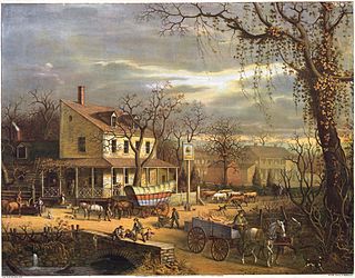
Inns are generally establishments or buildings where travelers can seek lodging, and usually, food and drink. Inns are typically located in the country or along a highway. Before the advent of motorized transportation, they also provided accommodation for horses.

<span class="mw-page-title-main">Motel</span> Hotel catering to motorists

A motel, also known as a motor hotel, motor inn or motor lodge, is a hotel designed for motorists, usually having each room entered directly from the parking area for motor vehicles rather than through a central lobby. Entering dictionaries after World War II, the word motel, coined as a portmanteau of "motor hotel", originates from the Milestone Mo-Tel of San Luis Obispo, California, which was built in 1925. The term referred to a type of hotel consisting of a single building of connected rooms whose doors faced a parking lot and in some circumstances, a common area or a series of small cabins with common parking. Motels are often individually owned, though motel chains do exist.

<span class="mw-page-title-main">U.S. Route 66</span> Former US Highway between Chicago and Santa Monica

U.S. Route 66 or U.S. Highway 66 was one of the original highways in the United States Numbered Highway System. It was established on November 11, 1926, with road signs erected the following year. The highway, which became one of the most famous roads in the United States, ran from Chicago, Illinois, through Missouri, Kansas, Oklahoma, Texas, New Mexico, and Arizona before terminating in Santa Monica in Los Angeles County, California, covering a total of 2,448 miles (3,940 km).

<span class="mw-page-title-main">Erick, Oklahoma</span> City in Oklahoma, United States

Erick is a city in Beckham County, Oklahoma, United States. It is located 15 miles (24 km) west of Sayre, the county seat, and 6 miles (9.7 km) east of the Oklahoma-Texas border. The population was 1,052 at the 2010 census.

<span class="mw-page-title-main">Amboy, California</span> Unincorporated community in California, United States

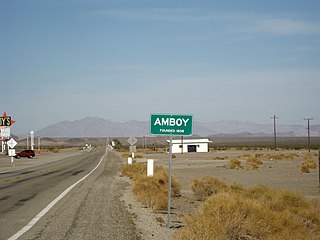
Amboy is an unincorporated community in San Bernardino County, in California's Mojave Desert, west of Needles and east of Ludlow on historic Route 66. It is roughly 60 miles (97 km) northeast of Twentynine Palms. As of 2020, the town's business district still contained a post office, a historic restaurant-motel, and a Route 66 tourist shop, all operated by the town's population of four people.

<span class="mw-page-title-main">Roadside attraction</span> Roadside attraction area for visitors

A roadside attraction is a feature along the side of a road meant to attract tourists. In general, these are places one might stop on the way to somewhere, rather than being a destination. They are frequently advertised with billboards. The modern tourist-oriented highway attraction originated as a U.S. and Canadian phenomenon in the 1940s to 1960s, and subsequently caught on in Australia.

<span class="mw-page-title-main">Devils Elbow, Missouri</span>

Devils Elbow is an unincorporated community in Pulaski County, Missouri, United States on historic U.S. Highway 66. It is situated on the Big Piney River and is named for a tight incised meander in the river known as a "devil of an elbow". The community is approximately five miles (8 km) east of St. Robert.

<span class="mw-page-title-main">Route 66 Association</span> Non-profit organization

Route 66 Association is the generic name of the non-profit associations established for preservation, restoration and promotion of the historic U.S. Route 66. They exist in all 8 Route 66 states: Illinois, Missouri, Kansas, Oklahoma, Texas, New Mexico, Arizona and California.

U.S. Highway associations were organizations to promote business and tourism along specific highways. The earliest ones also worked on interconnecting various state highways to create longer, multi-state highways. Since 1990, new associations have formed for preservation of historic highways.

<span class="mw-page-title-main">U.S. Route 66 in California</span> Highway in California

U.S. Route 66 is a part of a former United States Numbered Highway in the state of California that ran from the west in Santa Monica on the Pacific Ocean through Los Angeles and San Bernardino to Needles at the Arizona state line. It was truncated during the 1964 renumbering and its signage removed in 1974. The highway is now mostly replaced with several streets in Los Angeles, State Route 2 (SR 2), SR 110, SR 66, San Bernardino County Route 66 (CR 66), Interstate 15 (I-15), and I-40.

<span class="mw-page-title-main">Road trip</span> Long-distance journey on the road

A road trip, sometimes spelled roadtrip, is a long-distance journey traveled by automobile.

<span class="mw-page-title-main">U.S. Route 66 in Missouri</span> Section of U.S. Highway in Missouri, United States

U.S. Route 66 is a former east–west United States Numbered Highway, running from Santa Monica, California to Chicago, Illinois. In Missouri, the highway ran from downtown St. Louis at the Mississippi River to the Kansas state line west of Joplin. The highway was originally Route 14 from St. Louis to Joplin and Route 1F from Joplin to Kansas. It underwent two major realignments and several lesser realignments in the cities of St. Louis, Springfield, and Joplin. Current highways covering several miles of the former highway include Route 100, Route 366, Route 266, Route 96, and Route 66. Interstate 44 (I-44) approximates much of US 66 between St. Louis and Springfield.

<span class="mw-page-title-main">U.S. Route 66 in Oklahoma</span> Former highway in Oklahoma

The historic U.S. Route 66, sometimes known as the Will Rogers Highway after Oklahoma native Will Rogers, ran from west to northeast across the state of Oklahoma, along the path now taken by Interstate 40 (I-40) and State Highway 66 (SH-66). It passed through Oklahoma City, Tulsa, and many smaller communities. West of the Oklahoma City area, it has been largely replaced by I-40; the few independent portions that are still state-maintained are now I-40 Business. However, from Oklahoma City northeast to Kansas, the bypassing I-44 is mostly a toll road, and SH-66 remains as a free alternate.

<span class="mw-page-title-main">U.S. Route 66 in Arizona</span> Former designated US highway in Arizona

U.S. Route 66 also known as the Will Rogers Highway, was a major United States Numbered Highway in the state of Arizona from November 11, 1926, to June 26, 1985. US 66 covered a total of 385.20 miles (619.92 km) through Arizona. The highway ran from west to east, starting in Needles, California, through Kingman and Seligman to the New Mexico state line. Nationally, US 66 ran from Santa Monica, California, to Chicago, Illinois. In its height of popularity, US 66 was one of the most popular highways in the state of Arizona, sometimes carrying over one million cars a year.

<span class="mw-page-title-main">U.S. Route 66 in Illinois</span> Historic highway in Illinois

U.S. Route 66 was a United States Numbered Highway in Illinois that connected St. Louis, Missouri, and Chicago, Illinois. The historic Route 66, the Mother Road or Main Street of America, took long distance automobile travelers from Chicago to Southern California. The highway had previously been Illinois Route 4 and the road has now been largely replaced with Interstate 55 (I-55). Parts of the road still carry traffic and six separate portions of the roadbed have been listed on the National Register of Historic Places.

<span class="mw-page-title-main">U-Drop Inn</span> United States historic place

The U-Drop Inn, also known as Tower Station and U-Drop Inn and Tower Café, was built in 1936 in Shamrock, Texas along the historic Route 66 highway in Wheeler County. Inspired by the image of a nail stuck in soil, the building was designed by J. C. Berry. An unusual example of art deco architecture applied to a gas station and restaurant, the building features two flared towers with geometric detailing, curvilinear massing, glazed ceramic tile walls, and neon light accents. It has traditionally held two separate business: "Tower Station," a gas station on the western side, and the "U-Drop Inn," a café on the eastern side. Though it has passed hands several times in its history, the building has consistently housed the same types of businesses it was originally constructed for.

<span class="mw-page-title-main">U.S. Route 64 in Arkansas</span>

U.S. Route 64 is a U.S. highway running from Teec Nos Pos, Arizona east to Nags Head, North Carolina. In the U.S. state of Arkansas, the route runs 246.35 miles (396.46 km) from the Oklahoma border in Fort Smith east to the Tennessee border in Memphis. The route passes through several cities and towns, including Fort Smith, Clarksville, Russellville, Conway, Searcy, and West Memphis. US 64 runs parallel to Interstate 40 until Conway, when I-40 takes a more southerly route.

<span class="mw-page-title-main">Wagon Wheel Motel, Café and Station</span> Tourist stop in Cuba, Missouri

The Wagon Wheel Motel, Café and Station in Cuba, Missouri, is a 19-room independently owned historic U.S. Route 66 restored motel which has been serving travelers since 1938. The site opened as a café in 1936; the motel has remained in continuous operation since 1938. The motel rooms were fully restored in 2010, adding modern amenities such as HDTV and wireless Internet.

<span class="mw-page-title-main">66 Motel (Needles)</span> Building in Needles, California

66 Motel, an independently owned six-room motel established 1946–47 in Needles, California, formerly served travelers on U.S. Route 66 in California. Bypassed circa 1970 by Interstate 40, the motel has been used as single room occupancy apartments since the 1990s.

U.S. Bicycle Route 66 (USBR 66) is a United States Bicycle Route that follows the former U.S. Route 66 (US 66) across the United States. The first section of the route, spanning 358 miles (576 km) between Baxter Springs, Kansas, and St. Louis, Missouri, was designated as USBR 66 in 2018. A second section was designated in 2021 between Santa Monica, California, and the Arizona state line near Needles, California. The Oklahoma section was designated in 2022. The rest of the route remains proposed but not yet designated.

References

  1. Route 66 Dining & Lodging Guide (15th ed.). National Historic Route 66 Federation. 2011. ISBN   978-0970995179.
  2. "EZ66 Guide For Travelers 5th Edition - Jerry McClanahan". National Historic Route 66 Federation. Retrieved 2023-08-02.

Sources and further reading