
The Old Brick Capitol in Washington, D.C., served as the temporary meeting place of the Congress of the United States from 1815 to 1819, while the Capitol Building was rebuilt after the burning of Washington.
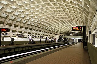
Farragut West station is a Washington Metro station in downtown Washington, D.C., United States. The side-platformed station was opened on July 1, 1977, and is operated by the Washington Metropolitan Area Transit Authority (WMATA). Providing service for the Blue, Silver, and Orange Lines, the station is located just west of Farragut Square with two entrances on I Street at 17th and 18th Streets NW.

Smithsonian station is a Washington Metro station at the National Mall in Washington, D.C., United States. The side platformed station was opened on July 1, 1977, and is operated by the Washington Metropolitan Area Transit Authority (WMATA). It is a stop on the Blue, Orange and Silver Lines. The station's south entrance is at the southwest corner of Independence Avenue and 12th Street, Southwest, the street elevator is at the northwest corner of the same intersection, and the north entrance is on the south side of the Mall near Jefferson Drive, Southwest.

Navy Yard–Ballpark station is a Washington Metro station in Washington, D.C., on the Green Line. The station is located in the Navy Yard/Near Southeast neighborhood of Southeast, with entrances on M Street at Half Street and New Jersey Avenue.
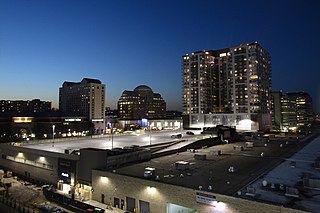
Pentagon City is an unincorporated neighborhood located in the southeast portion of Arlington County, Virginia, near the Pentagon and Arlington National Cemetery.

The history of Washington, D.C., is tied to its role as the capital of the United States. The site of the District of Columbia along the Potomac River was first selected by President George Washington. The city came under attack during the War of 1812 in an episode known as the Burning of Washington. Upon the government's return to the capital, it had to manage the reconstruction of numerous public buildings, including the White House and the United States Capitol. The McMillan Plan of 1901 helped restore and beautify the downtown core area, including establishing the National Mall, along with numerous monuments and museums.

Freedom Plaza, originally known as Western Plaza, is an open plaza in Northwest Washington, D.C., United States, located near 14th Street and Pennsylvania Avenue NW, adjacent to Pershing Park. The plaza features an inlay that partially depicts Pierre (Peter) Charles L'Enfant's plan for the City of Washington. The National Park Service administers the Plaza as part of its Pennsylvania Avenue National Historic Site and coordinates the Plaza's activities.

The Saint John Paul II National Shrine is a national shrine in Washington, D.C., sponsored by the Knights of Columbus. It is a place of prayer for Catholics and welcomes people of all faiths. The Shrine houses a permanent exhibit called A Gift of Love: the Life of Saint John Paul II and is home to the Redemptor Hominis Church and Luminous Mysteries Chapel, both of which are decorated with mosaic art designed by Rev. Marko Rupnik, S.J. Mass is celebrated daily in the Redemptor Hominis Church, and the Luminous Mysteries Chapel houses a first-class relic of John Paul II.

The Walter E. Washington Convention Center is a 2.3-million-square-foot (210,000 m2) convention center located in Washington, D.C., owned and operated by the city's convention arm, Events DC. Designed in a joint venture by the Atlanta-based architecture firm Tvsdesign, Washington, D.C.- based architects Devrouax & Purnell Architects Planners PC and Mariani and Associates, the convention center is located in a superblock bounded by Mount Vernon Square and 7th, 9th and N streets, N.W. It is served by the Mount Vernon Square station on the Yellow and Green lines of the Washington Metro. It was completed in 2003.

Jefferson Pier, Jefferson Stone, or the Jefferson Pier Stone, in Washington, D.C., marks the second prime meridian of the United States even though it was never officially recognized, either by presidential proclamation or by a resolution or act of Congress.
The Capitol Groundsa.k.a.Capitol Park (I), was a baseball field in Washington, D.C. The grounds were the home field for the Washington Nationals of the Union Association during the league's only season in 1884. The ballpark had a seating capacity of 6,000, and was where the Russell Senate Office Building stands today.

The National Intelligencer and Washington Advertiser was a newspaper published in Washington, D.C., from October 30, 1800 until 1870. It was the first newspaper published in the District, which was founded in 1790. It was originally a Tri-weekly publication. It covered early debates of the United States Congress. The paper had a strong bias to Republicans and Thomas Jefferson.

Downtown is the central business district of Washington, D.C., located in Northwest D.C. It is the third largest central business district in the United States. The "Traditional Downtown" has been defined as an area roughly between Union Station in the east and 16th Street NW in the west, and between the National Mall on the south and Massachusetts Avenue on the north, including Penn Quarter. However, nowadays, Downtown D.C. usually refers to a larger area, as the DC Office of Planning states:
…most residents, workers, and visitors think of Downtown in a broader sense — including areas as far north as Dupont Circle, as far west as Foggy Bottom, and as far east as Capitol Hill. Only about half of the central city workforce is located within the city’s traditional Downtown.

The boundary markers of the original District of Columbia are the 40 milestones that marked the four lines forming the boundaries between the states of Maryland and Virginia and the square of 100 square miles (259 km2) of federal territory that became the District of Columbia in 1801. Working under the supervision of three commissioners that President George Washington had appointed in 1790 in accordance with the federal Residence Act, a surveying team led by Major Andrew Ellicott placed these markers in 1791 and 1792. Among Ellicott's assistants were his brothers Joseph and Benjamin Ellicott, Isaac Roberdeau, George Fenwick, Isaac Briggs and an African American astronomer, Benjamin Banneker.

The Omni Shoreham Hotel is a historic resort and convention hotel in Northwest Washington, D.C., built in 1930 and owned by Omni Hotels. It is located one block west of the intersection of Connecticut Avenue and Calvert Street. The hotel is known for being a regular venue for Mark Russell and the Capitol Steps. It is a member of Historic Hotels of America, the official program of the National Trust for Historic Preservation.

The Washington Hilton is a Hilton hotel in Washington, D.C. It is located at 1919 Connecticut Avenue, N.W., roughly at the boundaries of the Kalorama, Dupont Circle, and Adams Morgan neighborhoods.

The Civil War Defenses of Washington were a group of Union Army fortifications that protected the federal capital city, Washington, D.C., from invasion by the Confederate States Army during the American Civil War.

The National Hotel epidemic was a mysterious sickness that began to afflict persons who stayed at the National Hotel in Washington, DC, in early January 1857. At the time, the hotel was the largest in the city. By some accounts, as many as 400 people became sick, and nearly three dozen died.

Murder Bay was a disreputable slum in Washington, D.C., roughly bounded by Constitution Avenue NW, Pennsylvania Avenue NW, and 13th and 15th Streets NW. The area was a center of crime through the early 20th century, with an extensive criminal underclass and prostitution occurring in several brothels and hotels in the area. The area was completely rebuilt during the construction of the Federal Triangle project in the late 1920s and 1930s.

The Arlington Hotel was a hotel in Washington, D.C.. It was built in 1868 and was considered the most opulent hotel in Washington, D.C. during the post-Civil War era, described as a "distinctive but low-keyed example of the Second Empire style."
