National Register of Historic Places listings in Louisville's West End

Last updated

This is a list of properties and historic districts on the National Register of Historic Places in the West End of Louisville, Kentucky. The table below includes 51 listings in the following neighborhoods:

Contents

Latitude and longitude coordinates of the sites listed on this page may be displayed in a map or exported in several formats by clicking on one of the links in the box below the map to the right. [1]

National Register sites elsewhere in Jefferson County are listed separately.


    This National Park Service list is complete through NPS recent listings posted March 15, 2024. [2]

Current listings

[3] Name on the RegisterImageDate listed [4] Location NeighborhoodDescription
1 B.F. Avery and Sons Industrial District
B.F. Avery and Sons Industrial District B.F. Avery District warehouses.jpg
B.F. Avery and Sons Industrial District
December 21, 1990
(#90001837)
1721-1821 7th St.
38°13′16″N85°46′23″W / 38.221111°N 85.773056°W / 38.221111; -85.773056 (B.F. Avery and Sons Industrial District)
Algonquin
2 Axton-Fisher Tobacco Company Warehouse
Axton-Fisher Tobacco Company Warehouse Axton-Fisher Tobacco Company Warehouse.jpg
Axton-Fisher Tobacco Company Warehouse
April 18, 2003
(#03000260)
1405 W. Broadway
38°14′54″N85°46′32″W / 38.248333°N 85.775556°W / 38.248333; -85.775556 (Axton-Fisher Tobacco Company Warehouse)
Russell
3 Wood F. Axton Hall, Simmons University August 4, 2016
(#16000497)
1811 Dumesnil St.
38°14′11″N85°47′15″W / 38.236354°N 85.787608°W / 38.236354; -85.787608 (Wood F. Axton Hall, Simmons University)
Park Hill
4 Bernheim Distillery Bottling Plant
Bernheim Distillery Bottling Plant Bernheim Distillery Bottling Plant.jpg
Bernheim Distillery Bottling Plant
September 8, 1983
(#83002634)
822-828 S. 15th St.
38°14′43″N85°46′40″W / 38.245278°N 85.777778°W / 38.245278; -85.777778 (Bernheim Distillery Bottling Plant)
California
5 Albert S. Brandeis Elementary School
Albert S. Brandeis Elementary School Brandeis.jpg
Albert S. Brandeis Elementary School
December 8, 1980
(#80001594)
1001 S. 26th St.
38°14′35″N85°47′43″W / 38.243056°N 85.795278°W / 38.243056; -85.795278 (Albert S. Brandeis Elementary School)
California
6 Brass Finishing Building, Standard Sanitary Manufacturing Company
Brass Finishing Building, Standard Sanitary Manufacturing Company Brass Finishing Building, Standard Sanitary Manufacturing Company.jpg
Brass Finishing Building, Standard Sanitary Manufacturing Company
March 15, 2005
(#05000142)
1547 S. 7th St.
38°13′30″N85°46′12″W / 38.225000°N 85.770000°W / 38.225000; -85.770000 (Brass Finishing Building, Standard Sanitary Manufacturing Company)
Algonquin
7 Broadway Temple A.M.E. Zion Church
Broadway Temple A.M.E. Zion Church Broadway Temple AMEZ Church in Louisville.jpg
Broadway Temple A.M.E. Zion Church
December 8, 1980
(#80001596)
662 S. 13th St.
38°14′53″N85°46′24″W / 38.248056°N 85.773333°W / 38.248056; -85.773333 (Broadway Temple A.M.E. Zion Church)
Russell
8 Chestnut Street Baptist Church
Chestnut Street Baptist Church Chestnut Street Baptist Church in Louisville.jpg
Chestnut Street Baptist Church
December 3, 1980
(#80001598)
912 W. Chestnut St.
38°14′59″N85°46′01″W / 38.249722°N 85.766944°W / 38.249722; -85.766944 (Chestnut Street Baptist Church)
Russell
9 Christ the King School and Church
Christ the King School and Church Christ the King Church, Louisville.jpg
Christ the King School and Church
September 8, 1983
(#83002647)
718-724 S. 44th St.
38°14′57″N85°49′32″W / 38.249167°N 85.825556°W / 38.249167; -85.825556 (Christ the King School and Church)
Shawnee
10 Church of Our Merciful Saviour
Church of Our Merciful Saviour Church of Our Merciful Saviour in Louisville.jpg
Church of Our Merciful Saviour
September 8, 1983
(#83002648)
473 S. 11th St.
38°15′09″N85°46′08″W / 38.252500°N 85.768889°W / 38.252500; -85.768889 (Church of Our Merciful Saviour)
Russell
11 Columbian School
Columbian School Columbian School on Dixie Highway.jpg
Columbian School
September 8, 1983
(#83002650)
1337 Dixie Hwy.
38°14′01″N85°47′17″W / 38.233611°N 85.788056°W / 38.233611; -85.788056 (Columbian School)
Park Hill Currently the Strothers Elementary Apartments
12 Anton Diebold House
Anton Diebold House Anton Diebold House.jpg
Anton Diebold House
September 8, 1983
(#83002653)
4303 W. Broadway
38°15′03″N85°49′28″W / 38.250833°N 85.824306°W / 38.250833; -85.824306 (Anton Diebold House)
Shawnee
13 J.W. Diebold, Jr. House
J.W. Diebold, Jr. House J.W. Diebold, Jr. House.jpg
J.W. Diebold, Jr. House
September 8, 1983
(#83002654)
4119 W. Broadway
38°15′02″N85°49′15″W / 38.250556°N 85.820833°W / 38.250556; -85.820833 (J.W. Diebold, Jr. House)
Shawnee
14 Basil Doerhoefer House
Basil Doerhoefer House Basil Doerhoefer House.jpg
Basil Doerhoefer House
September 8, 1983
(#83002657)
4432 W. Broadway
38°15′00″N85°49′36″W / 38.250000°N 85.826667°W / 38.250000; -85.826667 (Basil Doerhoefer House)
Shawnee
15 Peter C. Doerhoefer House
Peter C. Doerhoefer House Peter C. Doerhoefer House.jpg
Peter C. Doerhoefer House
September 8, 1983
(#83002658)
4422 W. Broadway
38°15′00″N85°49′33″W / 38.250000°N 85.825833°W / 38.250000; -85.825833 (Peter C. Doerhoefer House)
Shawnee
16 Doerhoefer–Hampton House
Doerhoefer-Hampton House Doerhoefer-Hampton House.jpg
Doerhoefer–Hampton House
July 16, 1979
(#79001002)
2422 W. Chestnut St.
38°15′09″N85°47′35″W / 38.252500°N 85.793056°W / 38.252500; -85.793056 (Doerhoefer–Hampton House)
Russell
17 Dumesnil Street ME Church
Dumesnil Street ME Church Dumesnil Street Methodist Church.jpg
Dumesnil Street ME Church
September 8, 1983
(#83002659)
1707 Dumesnil St.
38°14′10″N85°47′00″W / 38.236250°N 85.783333°W / 38.236250; -85.783333 (Dumesnil Street ME Church)
Park Hill
18 Fire Department Headquarters
Fire Department Headquarters Louisville Fire Department Headquarters.jpg
Fire Department Headquarters
November 7, 1981
(#81000283)
1135 W. Jefferson St.
38°15′20″N85°46′12″W / 38.255556°N 85.770000°W / 38.255556; -85.770000 (Fire Department Headquarters)
Russell
19 Ford Motor Plant
Ford Motor Plant West End Ford Motor Plant.jpg
Ford Motor Plant
January 27, 1983
(#83002666)
1400 Southwestern Parkway
38°14′06″N85°50′00″W / 38.235000°N 85.833333°W / 38.235000; -85.833333 (Ford Motor Plant)
West End Louisville
20 Stephen Foster Elementary School
Stephen Foster Elementary School Stephen Foster Elementary School on Garland Avenue.jpg
Stephen Foster Elementary School
April 4, 2006
(#06000337)
4020 Garland Ave.
38°14′47″N85°49′08″W / 38.246389°N 85.818889°W / 38.246389; -85.818889 (Stephen Foster Elementary School)
Chickasaw
21 Great Atlantic & Pacific Tea Company Bakery & Warehouse March 14, 2024
(#100010096)
901 S. 15th Street
38°14′38″N85°46′38″W / 38.2438°N 85.7771°W / 38.2438; -85.7771 (Great Atlantic & Pacific Tea Company Bakery & Warehouse)
22 Holy Cross Catholic Church, School and Rectory
Holy Cross Catholic Church, School and Rectory St. Martin de Porres Catholic Church, Louisville.jpg
Holy Cross Catholic Church, School and Rectory
September 8, 1983
(#83002684)
3112 W. Broadway
38°14′58″N85°48′18″W / 38.249444°N 85.805000°W / 38.249444; -85.805000 (Holy Cross Catholic Church, School and Rectory)
Russell
23 Hook and Ladder Company No. 4
Hook and Ladder Company No. 4 Hook and Ladder Company No. 4, Louisville.jpg
Hook and Ladder Company No. 4
November 7, 1980
(#80001603)
2301 Jefferson St.
38°15′28″N85°47′21″W / 38.257778°N 85.789250°W / 38.257778; -85.789250 (Hook and Ladder Company No. 4)
Russell
24 Hook and Ladder Company No. 5
Hook and Ladder Company No. 5 Hook and Ladder Company No. 5, Louisville.jpg
Hook and Ladder Company No. 5
November 7, 1980
(#80001604)
1824 Garland Ave.
38°14′37″N85°47′08″W / 38.243611°N 85.785556°W / 38.243611; -85.785556 (Hook and Ladder Company No. 5)
California
25 Jefferson Branch Louisville Free Public Library
Jefferson Branch Louisville Free Public Library Old Louisville Jefferson Branch library.jpg
Jefferson Branch Louisville Free Public Library
July 18, 1979
(#79001009)
1718 W. Jefferson St.
38°15′22″N85°46′46″W / 38.256111°N 85.779444°W / 38.256111; -85.779444 (Jefferson Branch Louisville Free Public Library)
Russell
26 Knights of Pythias Temple
Knights of Pythias Temple Louisville KoP Temple.jpg
Knights of Pythias Temple
November 29, 1978
(#78001358)
928-932 W. Chestnut St.
38°14′59″N85°46′04″W / 38.249722°N 85.767778°W / 38.249722; -85.767778 (Knights of Pythias Temple)
Russell
27 Louisville and Nashville Railroad Office Building
Louisville and Nashville Railroad Office Building L&N Office Building Louisville closeup.JPG
Louisville and Nashville Railroad Office Building
September 8, 1983
(#83002696)
908 W. Broadway
38°14′48″N85°46′04″W / 38.246667°N 85.767778°W / 38.246667; -85.767778 (Louisville and Nashville Railroad Office Building)
California
28 Louisville Free Public Library, Western Colored Branch
Louisville Free Public Library, Western Colored Branch Louisville Free Public Library, Western Colored Branch.jpg
Louisville Free Public Library, Western Colored Branch
December 6, 1975
(#75000771)
604 S. 10th St.
38°14′59″N85°46′05″W / 38.249722°N 85.768056°W / 38.249722; -85.768056 (Louisville Free Public Library, Western Colored Branch)
Russell
29 Marlow Place Bungalows District
Marlow Place Bungalows District Bungalows east of Marlow Place.jpg
Marlow Place Bungalows District
September 8, 1983
(#83002699)
3139 to 3209 W. Broadway
38°15′00″N85°48′20″W / 38.250000°N 85.805556°W / 38.250000; -85.805556 (Marlow Place Bungalows District)
Russell
30 J.B. McFerran School
J.B. McFerran School J.B. McFerran School.jpg
J.B. McFerran School
September 8, 1983
(#83002703)
1515 Cypress St.
38°13′47″N85°47′54″W / 38.229722°N 85.798333°W / 38.229722; -85.798333 (J.B. McFerran School)
Algonquin
31 Mengel Box Company
Mengel Box Company Mengel Box Company site.jpg
Mengel Box Company
September 8, 1983
(#83002705)
1247-1299 S. 12th St.
38°14′04″N85°46′25″W / 38.234444°N 85.773611°W / 38.234444; -85.773611 (Mengel Box Company)
Park Hill
32 Parkland Evangelical Church
Parkland Evangelical Church Parkland Evangelical Church.jpg
Parkland Evangelical Church
September 8, 1983
(#83002717)
1102 S. 26th St.
38°14′26″N85°47′47″W / 38.240417°N 85.796389°W / 38.240417; -85.796389 (Parkland Evangelical Church)
Parkland
33 Parkland Historic District
Parkland Historic District Greater Tabernacle Missionary Baptist Church, Parkland.jpg
Parkland Historic District
June 4, 1980
(#80001613)
Roughly bounded by railroad tracks, Hale Ave., and S. 26th and S. 30th Sts.
38°14′12″N85°48′00″W / 38.236667°N 85.800000°W / 38.236667; -85.800000 (Parkland Historic District)
Parkland
34 Parkland Junior High School
Parkland Junior High School Parkland Junior High School.jpg
Parkland Junior High School
September 8, 1983
(#83002718)
2509 Wilson Ave.
38°14′06″N85°47′44″W / 38.235000°N 85.795556°W / 38.235000; -85.795556 (Parkland Junior High School)
Parkland
35 J.J. Reilly Manufacturing Building June 13, 2019
(#100004097)
1234 Rowan St.
38°15′35″N85°46′15″W / 38.2596°N 85.7709°W / 38.2596; -85.7709 (J.J. Reilly Manufacturing Building)
36 Russell Historic District
Russell Historic District House on 21st Street in Russell.jpg
Russell Historic District
May 7, 1980
(#80001617)
Roughly bounded by S. 15th, S. 26th, Congress, and W. Broadway Sts.; also the junction of Muhammad Ali Boulevard and S. 17th St.
38°15′20″N85°47′20″W / 38.255556°N 85.788889°W / 38.255556; -85.788889 (Russell Historic District)
Russell Junction address represents a boundary increase of March 24, 2000
37 St. Anthony's Roman Catholic Church, Rectory, Convent, and School
St. Anthony's Roman Catholic Church, Rectory, Convent, and School St. Anthony's Catholic Church, Louisville.jpg
St. Anthony's Roman Catholic Church, Rectory, Convent, and School
March 1, 1982
(#82002720)
2222-2233 W. Market St.
38°15′30″N85°47′16″W / 38.258333°N 85.787778°W / 38.258333; -85.787778 (St. Anthony's Roman Catholic Church, Rectory, Convent, and School)
Russell
38 St. Columba Catholic Campus
St. Columba Catholic Campus St Columba Catholic Campus.jpg
St. Columba Catholic Campus
April 5, 2005
(#05000143)
3514 W. Market
38°15′39″N85°48′33″W / 38.260833°N 85.809167°W / 38.260833; -85.809167 (St. Columba Catholic Campus)
Shawnee
39 St. George's Roman Catholic Church
St. George's Roman Catholic Church St. George's Catholic Church, Louisville.jpg
St. George's Roman Catholic Church
October 29, 1982
(#82001563)
1809 Standard Ave.
38°13′53″N85°47′23″W / 38.231389°N 85.789722°W / 38.231389; -85.789722 (St. George's Roman Catholic Church)
Park Hill
40 St. Peter's German Evangelical Church
St. Peter's German Evangelical Church St. Peter's German Evangelical Church in Louisville.jpg
St. Peter's German Evangelical Church
December 4, 1980
(#80001621)
1231 W. Jefferson St.
38°15′20″N85°46′16″W / 38.255556°N 85.771111°W / 38.255556; -85.771111 (St. Peter's German Evangelical Church)
Russell
41 Shawnee Elementary School
Shawnee Elementary School Shawnee Elementary School in Louisville.jpg
Shawnee Elementary School
November 2, 1984
(#84000275)
4151 Herman St.
38°15′43″N85°49′08″W / 38.261944°N 85.818889°W / 38.261944; -85.818889 (Shawnee Elementary School)
Shawnee
42 Shawnee High School
Shawnee High School ShawneeHighSchool LouisvilleKY.jpg
Shawnee High School
November 2, 1984
(#84000277)
4015 Herman St.
38°15′43″N85°48′56″W / 38.261944°N 85.815556°W / 38.261944; -85.815556 (Shawnee High School)
Shawnee
43 F.M. Tiller House
F.M. Tiller House F.M. Tiller House.jpg
F.M. Tiller House
September 8, 1983
(#83002741)
4309 W. Broadway
38°15′03″N85°49′30″W / 38.250833°N 85.825000°W / 38.250833; -85.825000 (F.M. Tiller House)
Shawnee
44 Union Station
Union Station Louisville Union Station.jpg
Union Station
August 11, 1975
(#75000777)
1000 W. Broadway
38°14′48″N85°46′08″W / 38.246667°N 85.768889°W / 38.246667; -85.768889 (Union Station)
California
45 Universal Car Company
Universal Car Company Universal Car Company.jpg
Universal Car Company
May 2, 2001
(#01000454)
2500 W. Broadway
38°14′57″N85°47′38″W / 38.249167°N 85.793889°W / 38.249167; -85.793889 (Universal Car Company)
California
46 Virginia Avenue Colored School
Virginia Avenue Colored School Virginia Avenue Colored School front detail.jpg
Virginia Avenue Colored School
March 31, 2004
(#04000244)
3628 Virginia Ave.
38°14′21″N85°48′53″W / 38.239167°N 85.814722°W / 38.239167; -85.814722 (Virginia Avenue Colored School)
Chickasaw
47 Henry Vogt Machine Company Shop
Henry Vogt Machine Company Shop Henry Vogt Machine Company Shop.jpg
Henry Vogt Machine Company Shop
February 11, 1982
(#82002727)
1000 W. Ormsby Ave.
38°13′58″N85°46′15″W / 38.232778°N 85.770833°W / 38.232778; -85.770833 (Henry Vogt Machine Company Shop)
Park Hill
48 Warehouse A, Brown-Forman Corporation
Warehouse A, Brown-Forman Corporation Brown-Forman warehouse A and bottling house.jpg
Warehouse A, Brown-Forman Corporation
April 16, 1990
(#89001144)
1809 Garland Ave.
38°14′40″N85°47′04″W / 38.244444°N 85.784444°W / 38.244444; -85.784444 (Warehouse A, Brown-Forman Corporation)
California
49 Wedekind House and Servant's Quarters
Wedekind House and Servant's Quarters Wedekind Servant's Quarters.jpg
Wedekind House and Servant's Quarters
September 8, 1983
(#83002747)
2630 and 2532 W. Burnett St.
38°13′56″N85°47′57″W / 38.232222°N 85.799028°W / 38.232222; -85.799028 (Wedekind House and Servant's Quarters)
Park Hill
50 White Mills Distillery Company
White Mills Distillery Company White Mills Distillery Company.jpg
White Mills Distillery Company
December 8, 1978
(#78001371)
850 Dixie Hwy.
38°14′42″N85°47′03″W / 38.245000°N 85.784167°W / 38.245000; -85.784167 (White Mills Distillery Company)
California
51 Whiteside Bakery
Whiteside Bakery Whiteside Bakery.jpg
Whiteside Bakery
April 24, 1979
(#79001014)
1400 W. Broadway St.
38°14′52″N85°46′32″W / 38.247778°N 85.775556°W / 38.247778; -85.775556 (Whiteside Bakery)
California

See also

Related Research Articles

<span class="mw-page-title-main">National Register of Historic Places listings in Jefferson County, New York</span>

List of the National Register of Historic Places listings in Jefferson County, New York

<span class="mw-page-title-main">National Register of Historic Places listings in Jefferson County, Kentucky</span>

The table below includes sites listed on the National Register of Historic Places (NRHP) in Jefferson County, Kentucky except those in the following neighborhoods/districts of Louisville: Anchorage, Downtown, The Highlands, Old Louisville, Portland and the West End. Links to tables of listings in these other areas are provided below.

<span class="mw-page-title-main">National Register of Historic Places listings in Jefferson County, Florida</span>

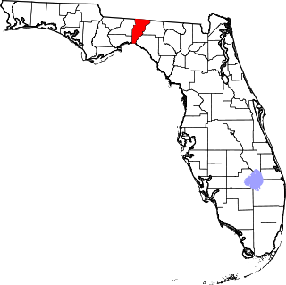
This is a list of the National Register of Historic Places listings in Jefferson County, Florida.

This is a list of properties and historic districts on the National Register of Historic Places in downtown Louisville, Kentucky. Latitude and longitude coordinates of the 85 sites listed on this page may be displayed in a map or exported in several formats by clicking on one of the links in the adjacent box.

<span class="mw-page-title-main">National Register of Historic Places listings in Jefferson County, Pennsylvania</span>

This is a list of the National Register of Historic Places listings in Jefferson County, Pennsylvania.

This is a list of properties and historic districts on the National Register of Historic Places in Anchorage, Kentucky. Latitude and longitude coordinates of the 35 sites listed on this page may be displayed in a map or exported in several formats by clicking on one of the links in the adjacent box.

This is a list of properties and historic districts on the National Register of Historic Places in the Portland neighborhood of Louisville, Kentucky (roughly bounded by the Ohio River on the north; N. 10th St. to the east; W. Market St. to the south; and I-264 and the Shawnee Golf Course to the west. Latitude and longitude coordinates of the 35 sites listed on this page may be displayed in a map or exported in several formats by clicking on one of the links in the adjacent box.

<span class="mw-page-title-main">National Register of Historic Places listings in Shelby County, Kentucky</span>

This is a list of the National Register of Historic Places listings in Shelby County, Kentucky.

<span class="mw-page-title-main">National Register of Historic Places listings in Trimble County, Kentucky</span>

This is a list of the National Register of Historic Places listings in Trimble County, Kentucky.

<span class="mw-page-title-main">National Register of Historic Places listings in Spencer County, Kentucky</span>

This is a list of the National Register of Historic Places listings in Spencer County, Kentucky.

<span class="mw-page-title-main">National Register of Historic Places listings in Meade County, Kentucky</span>

This is a list of the National Register of Historic Places listings in Meade County, Kentucky.

<span class="mw-page-title-main">National Register of Historic Places listings in Nelson County, Kentucky</span>

This is a list of the National Register of Historic Places listings in Nelson County, Kentucky.

<span class="mw-page-title-main">National Register of Historic Places listings in Oldham County, Kentucky</span>

This is a list of the National Register of Historic Places listings in Oldham County, Kentucky.

<span class="mw-page-title-main">National Register of Historic Places listings in Henry County, Kentucky</span>

This is a list of the National Register of Historic Places listings in Henry County, Kentucky.

<span class="mw-page-title-main">National Register of Historic Places listings in Clark County, Indiana</span>

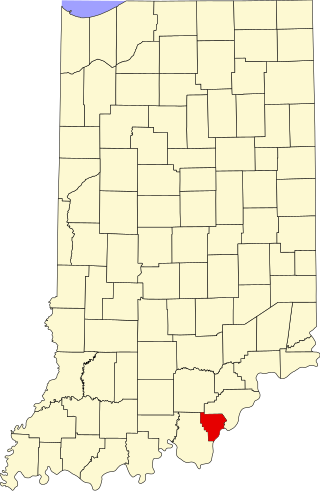
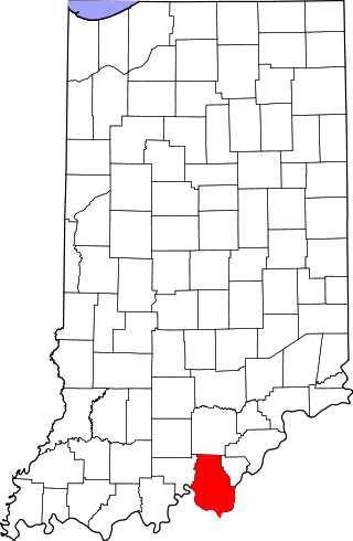
This is a list of the National Register of Historic Places listings in Clark County, Indiana.

<span class="mw-page-title-main">National Register of Historic Places listings in Floyd County, Indiana</span>

This is a list of the National Register of Historic Places listings in Floyd County, Indiana.

<span class="mw-page-title-main">National Register of Historic Places listings in Harrison County, Indiana</span>

This is a list of the National Register of Historic Places listings in Harrison County, Indiana.

<span class="mw-page-title-main">National Register of Historic Places listings in Bullitt County, Kentucky</span>

This is a list of the National Register of Historic Places listings in Bullitt County, Kentucky.

This is a list of properties and historic districts on the National Register of Historic Places in The Highlands, Louisville, Kentucky. The table below includes 30 listings in the following neighborhoods:

This is a list of properties and historic districts on the National Register of Historic Places in Old Louisville, Kentucky. Latitude and longitude coordinates of the 33 sites listed on this page may be displayed in a map or exported in several formats by clicking on one of the links in the adjacent box.

References

  1. The latitude and longitude information provided in this table was derived originally from the National Register Information System, which has been found to be fairly accurate for about 99% of listings. Some locations in this table may have been corrected to current GPS standards.
  2. National Park Service, United States Department of the Interior, "National Register of Historic Places: Weekly List Actions", retrieved March 15, 2024.
  3. Numbers represent an alphabetical ordering by significant words. Various colorings, defined here, differentiate National Historic Landmarks and historic districts from other NRHP buildings, structures, sites or objects.
  4. The eight-digit number below each date is the number assigned to each location in the National Register Information System database, which can be viewed by clicking the number.