The National Space Program (PSN) horizons 2020 planned to put in place space infrastructures, and space systems and increase the specialized human resources in space technologies. Among the space systems planned in the PSN are Algeria's satellites (Alsat-2A, Alsat -2b, Alsat -3, Alsat -4, African Resource Management ARM and the communications satellite Alcomsat-1), of which a significant number should be partly or totally integrated into the Algerian center for satellite development "CDS". CDS offers the technological environment for national competence to develop the future Algerian satellite systems. Algeria's objective is to make space tools a powerful instrument in national prosperity in the fields of earth observation, meteorology and communications.
CDS comprises: [1]
The CDS is organized in 6 departments:
Those departments house mechanical and thermal, electrical, electronic and optics research and development laboratories.
The satellite integration building consists of a large clean room of class 100000, with 4 subareas dedicated to:
Those areas are separated by sliding curtains.
The satellite environmental tests building is also planned for the future, this building shall consist of:
Missions: [1]
The "Alsat program " is a constellation of Algerian Earth observation satellites operated by the Algerian Space Agency. Algeria has three operational units and one retired mission.
Alsat-1 is the first Earth observation satellite of Algeria. Its principal mission is monitoring natural resources. It was a Disaster Monitoring Constellation (DMC) satellite that is developed and coordinated by Surrey Satellite Technology Ltd (SSTL).
The satellite is a 60-centimeter cube, and weighs about 92 kilograms. The imaging system covers the green, red, and the near infrared, at a resolution of 32 meters.
It was placed in orbit by a kosmos-3M launch vehicle from the Russian cosmodrome of Plessetsk, on 28 November 2002. Its orbit is heliosynchronous at an altitude of about 700 kilometers with orbital inclination of 98°.
Its first images were received on December 17, 2002 at the reception stations of the Center of space technics (Centre national des techniques spatiales CNTS) at Arzew, Algeria. Alsat-1 completed its mission on 15 August 2010.
On February 1, 2006, EADS Astrium announced the signature of a contract for the realisation of two (02) satellites (Alsat-2A et Alsat-2B) of the Alsat-2 Program. [2] The Alsat-2 program includes also the establishment of two ground control segments and an image terminal to control and pilot the satellites from Algerian territory.
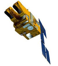
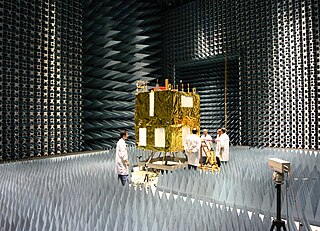
Alsat-2A is a high resolution Earth observation satellite that was integrated and tested in France at the d'EADS Astrium workshops with participation of 29 Algerian engineers. It was launched by a Polar Satellite Launch Vehicle on 12 July 2010. With a resolution of 2.5m in panchromatic mode, and of 10m in multispectral mode, it provides satellite images for multiple applications such as topography, agriculture, cartography, and protection of the environment. [3]
The satellite is based on the Myriade platform of the Centre national d'études spatiales (CNES) and is placed in a polar heliosynchonous orbit.
It has the following characteristics: [2]
Alsat-2b is the second high resolution Earth observation satellite and the 2nd unit of the Alsat-2 program launched on 26 September 2016 with a PSLV-C35 rocket. [4]
Alsat-2b was made in Algeria by ASAL, weights about 125 kg. [5] its characteristics and payload are not yet published by the Algerian space agency. Alsat-2B is operational. [6] Images taken by Alsat 2B in multispectral mode (visible and near infra-red) and in panchromatic mode will be invested in important thematic and economic fields such as: urban and agricultural planification of the territory and littoral, cartography, following mega-projects, etc.
Alsat-1B is a medium resolution Earth observation satellite based on the SSTL-100 platform. [4] the satellite weights 110 kg. It was integrated at the center of development of satellites of the Algerian space agency in Oran. its images are used for the management of natural disasters and the protection of the environment. [4]
Alsat-1b was launched on 26 September 2016 by a PSLV-C35 launch vehicle. [4] [6] Alsat-1B is a Disaster Monitoring Constellation (DMC) satellite coordinated by Surrey Satellite Technology Limited (SSTL). [6]
The satellite carries: [7]
1- ALITE (Algerian Imager Telescope): delivers medium resolution images of 12m in panchromatic mode and 24m in multispectral mode.
2- radiation monitor: permits a better understanding of the environment of radiation that satellites circulating in low Earth orbit are exposed to.
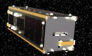
Alsat-1N or Alsat-Nano is a 3U technology demonstration nano-satellite,weight of 3.5 kg.built by an Algerian-British team in application of the cooperation agreement signed between the Algerian Space Agency and the l'UK Space Agency. 18 Algerian engineers used the satellite as a pedagogical tool during their graduation research at Surray University.
the main mission objectives are test of three innovative components: camera, fin solar films and a measure of radiation. Data obtained by the satellite will be studied by Algerian and British researchers. [6] Alsat-1N was launched on September 26, 2016 by an ISRO PSLV
Three scientific and technology demonstration payloads:
Is a telecommunications satellites program.
Alcomsat-1 was launched on Dec. 11, 2017 by LM-3B from Xichang Satellite Center. After several maneuvers, it reached the orbital location of 24.8°W. Following the IOAR which was accomplished after the in-orbit test, ASAL confirmed that the in-orbit delivery occurred on March 1.
The Alcomsat-1 is the ninth telecommunication satellite delivered to the international client by China Aerospace; it is also the first cooperation with Algeria in aerospace industry.
The Alcomsat-1 satellite program is the first communications satellite program of Algeria. It covers the Algerian territory and the surrounding area, will be mainly used in the fields of broadcast, emergency communications, remote education, e-government, enterprise communications, satellite broadband, and satellite based augmentation system application, etc. [8]
Alsat-3 and Alsat-4 are also planned to cover national needs. [1]
The Algerian Space Agency in charge of the National Space Program of Algeria is now capable of:
SPOT is a commercial high-resolution optical Earth imaging satellite system operating from space. It is run by Spot Image, based in Toulouse, France. It was initiated by the CNES in the 1970s and was developed in association with the SSTC and the Swedish National Space Board (SNSB). It has been designed to improve the knowledge and management of the Earth by exploring the Earth's resources, detecting and forecasting phenomena involving climatology and oceanography, and monitoring human activities and natural phenomena. The SPOT system includes a series of satellites and ground control resources for satellite control and programming, image production, and distribution. Earlier satellites were launched using the European Space Agency's Ariane 2, 3, and 4 rockets, while SPOT 6 and SPOT 7 were launched by the Indian PSLV.

Satellite images are images of Earth collected by imaging satellites operated by governments and businesses around the world. Satellite imaging companies sell images by licensing them to governments and businesses such as Apple Maps and Google Maps.
The National Space Research and Development Agency (NASRDA) is the national space agency of Nigeria. It is a parastatal under Federal Ministry of Innovation, Science and Technology. The agency is based in the Nigerian capital city of Abuja in the Lugbe district and has a ground receiving station, among various other sites. In the past, it has cooperated in space technology with the United Kingdom, China, Ukraine and Russia. The agency has struggled with meeting its financial plans and some of its facilities are rundown. Despite this, the space agency is one of the most advanced space agencies in Africa, boasting of four satellites and very grand ambitions. Nigeria's satellites have been praised for their high-resolution images. NASRDA is host to one of UN-SPIDER's Regional Support Offices (RSO) in Africa.
The Disaster Monitoring Constellation for International Imaging (DMCii) or just Disaster Monitoring Constellation (DMC) consists of a number of remote sensing satellites constructed by Surrey Satellite Technology Ltd (SSTL) and operated for the Algerian, Nigerian, Turkish, British and Chinese governments by DMC International Imaging. The DMC provides emergency Earth imaging for disaster relief under the International Charter for Space and Major Disasters, which the DMC formally joined in November 2005. Other DMC Earth imagery is used for a variety of civil applications by a variety of governments. Spare available imaging capacity is sold under contract.
Astrium was an aerospace manufacturer subsidiary of the European Aeronautic Defence and Space Company (EADS) that provided civil and military space systems and services from 2006 to 2013. In 2012, Astrium had a turnover of €5.8 billion and 18,000 employees in France, Germany, the United Kingdom, Spain and the Netherlands. Astrium was a member of Institute of Space, its Applications and Technologies.

The China–Brazil Earth Resources Satellite program (CBERS) is a technological cooperation program between Brazil and China which develops and operates Earth observation satellites.
China–Brazil Earth Resources Satellite 2B (CBERS-2B), also known as Ziyuan 1-2B, was a remote sensing satellite operated as part of the China–Brazil Earth Resources Satellite program between the Chinese Center for Resources Satellite Data and Application and Brazilian National Institute for Space Research. The third CBERS satellite to fly, it was launched by China in 2007 to replace CBERS-2.
China–Brazil Earth Resources Satellite 1 (CBERS-1), also known as Ziyuan I-01 or Ziyuan 1A, is a remote sensing satellite which was operated as part of the China–Brazil Earth Resources Satellite program between the China National Space Administration and Brazil's National Institute for Space Research. The first CBERS satellite to fly, it was launched by China in 1999.
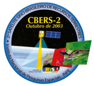
China–Brazil Earth Resources Satellite 2 (CBERS-2), also known as Ziyuan I-02 or Ziyuan 1B, was a remote sensing satellite operated as part of the China–Brazil Earth Resources Satellite program between the Chinese Center for Resources Satellite Data and Application and Brazilian National Institute for Space Research. The second CBERS satellite to fly, it was launched by China in 2003 to replace CBERS-1.
Deimos-1 is a Spanish Earth imaging satellite which is operated by Deimos Imaging who commercializes its imagery directly but also has distribution agreements with other entities like Astrium GEO and DMC International Imaging.
ALSAT-1 is the first Algerian satellite and it is part of a group of satellites collectively known as the Disaster Monitoring Constellation (DMC). The satellite was built by a group of engineers from Surrey Satellite Technology (SSTL) and Algerian Centre National des Techniques Spatiales (CNTS). It was the first DMC satellite to be launched of the five to seven that are planned. The DMC was the first satellite constellation designed for that objective. The launch took place on 28 November 2002 from the Plesetsk Cosmodrome in northern Russia on a Kosmos-3M launcher in -20 degree Celsius weather. It completed its mission after seven years and nine months in August 2010. The satellite was designed to operate for five years.
The Algerian Space Agency, was established on January 16, 2002 in Bouzareah, Algiers. The agency is in charge of the Algerian space program, and has flown five different satellites.
VNREDSat-1 is the first optical Earth Observing satellite of Vietnam; its primary mission is to monitor and study the effects of climate change, predict and take measures to prevent natural disasters, and optimise the management of Vietnam's natural resources.
Planet Labs PBC is a publicly trading American Earth imaging company based in San Francisco, California. Their goal is to image the entirety of the Earth daily to monitor changes and pinpoint trends.
Alsat-1B is an Algerian satellite operated by the Agence Spatiale Algerienne for agricultural and disaster monitoring. The contract for the mission was signed in July 2014. The satellite is based on the SSTL-100 bus. The satellite weighs 103 kilograms (227 lb) and carries an Earth imaging payload with 12-metre (39 ft) panchromatic imager and 24-metre (79 ft) multispectral cameras.
Alsat-2A is an Algerian satellite operated by the Algerian Space Agency for cartography, management of agriculture, forestry, water, mineral and oil resources. The satellite weighs 117 kilograms (258 lb) and carries an Earth optical payload.

Sentinel-2B is a European optical imaging satellite that was launched on 7 March 2017. It is the second Sentinel-2 satellite launched as part of the European Space Agency's Copernicus Programme, and with its orbit phased 180° against its sister satellite, Sentinel-2A. The satellite carries a wide swath high-resolution multispectral imager with 13 spectral bands. It provides information for agriculture and forestry, among other services, allowing for prediction of crop yields.

PSLV-C42 was the 44th mission of the Indian Polar Satellite Launch Vehicle (PSLV) program and its 12th mission in the Core Alone (CA) configuration. PSLV-C42 successfully carried and deployed 2 Earth observation satellites in Sun-synchronous orbits at an altitude of 588 kilometres (365 mi). It was launched on 16 September 2018 by the Indian Space Research Organisation (ISRO) from the first launch pad of the Satish Dhawan Space Centre at Sriharikota, Andhra Pradesh. The two international satellites were launched as part of a commercial arrangement between Surrey Satellite Technology Limited (SSTL) and ISRO's commercial arm Antrix Corporation Limited, run under the auspices of the Indian Government's Department of Space.

The Defence Space Agency (DSA) is an integrated tri-services agency of the Indian Armed Forces headquartered in Bengaluru, Karnataka, India. The agency is tasked with operating the space-warfare and Satellite Intelligence assets of India. The DSA draws personnel from all three branches of the Armed Forces.
İMECE is an Earth observation satellite designed and developed by TÜBİTAK Space Technologies Research Institute and produced in Türkiye to provide high resolution imagery.