The National Spatial Strategy 2002-2020 was a twenty-year planning framework, with an aim of balancing social, economic and physical development in the Republic of Ireland.
The National Spatial Strategy 2002-2020 was a twenty-year planning framework, with an aim of balancing social, economic and physical development in the Republic of Ireland.
The strategy seeks both to prevent the Greater Dublin Area becoming an area of problematic urban sprawl, and also to prevent rural areas becoming fragmented with scattered one-off housing. It seeks to do this by identifying various urban centres outside Dublin as focus points for concentrated development, drawing this away from both Dublin and the rural areas. The report describes two tiers of regional centres: a few larger "Gateways" with smaller "Hubs" as more local foci. When the NSS was being developed, William Thomas proposed a brand new city in the west of the country, gaining some news coverage. [1]
There was controversy over the selection of the gateways and hubs, with towns not selected feeling aggrieved. A notable concept was the "Midland Gateway" comprising three of the larger towns in the midlands. The intention was a polycentric model with some inspiration from the Triangle Region Denmark. The inclusion in the plan of Derry, which is across the border in Northern Ireland, was a reflection of improved cross-border co-operation in the wake of the Northern Ireland peace process.

County Dublin is a county in Ireland, and holds its capital city, Dublin. It is located on the island's east coast, within the province of Leinster. Until 1994, County Dublin was a single local government area; in that year, the county council was divided into three new administrative counties: Dún Laoghaire–Rathdown, Fingal and South Dublin. The three administrative counties together with Dublin City proper form a NUTS III statistical region of Ireland. County Dublin remains a single administrative unit for the purposes of the courts and Dublin County combined with Dublin City forms the Judicial County of Dublin, including Dublin Circuit Court, the Dublin County Registrar and the Dublin Metropolitan District Court. Dublin also sees law enforcement and fire services administered county-wide.

Derry, officially Londonderry, is the largest city in County Londonderry, the second-largest in Northern Ireland and the fifth-largest on the island of Ireland. The old walled city lies on the west bank of the River Foyle, which is spanned by two road bridges and one footbridge. The city now covers both banks.
Most of the transport system in Ireland is in public hands, either side of the Irish border. The Irish road network has evolved separately in the two jurisdictions into which Ireland is divided, while the Irish rail network was mostly created prior to the partition of Ireland.
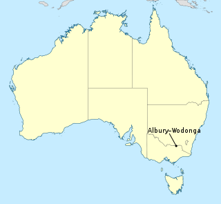
Albury–Wodonga is the broad settlement incorporating the twin Australian cities of Albury and Wodonga, which are separated geographically by the Murray River and politically by a state border: Albury on the north of the river is part of New South Wales, while Wodonga on the south bank is in Victoria.

County Donegal is a county of Ireland in the province of Ulster and in the Northern and Western Region. It is named after the town of Donegal in the south of the county. It has also been known as County Tyrconnell or Tirconaill, after the historic territory. Donegal County Council is the local council and Lifford is the county town.

In general, a rural area or a countryside is a geographic area that is located outside towns and cities. Typical rural areas have a low population density and small settlements. Agricultural areas and areas with forestry are typically described as rural, as well as other areas lacking substantial development. Different countries have varying definitions of rural for statistical and administrative purposes.

NI Railways, also known as Northern Ireland Railways, is the railway operator in Northern Ireland. NIR is a subsidiary of Translink, whose parent company is the Northern Ireland Transport Holding Company (NITHCo), and is one of nine publicly owned train operators in the United Kingdom, the others being Direct Rail Services, Caledonian Sleeper, Northern Trains, Transport for Wales Rail, Southeastern, LNER, ScotRail, and TransPennine Express. It has a common Board of Management with the other two companies in the group, Ulsterbus and Metro.
South Dublin is a county in Ireland, within the province of Leinster and the Eastern and Midland Region. It is one of three successor counties to County Dublin, which was disestablished for administrative purposes in 1994. South Dublin County Council is the local authority for the county. The county contains both dense suburbs of Dublin and stretches of unpopulated mountains. In 2022 it had a population of 301,705, making it the fourth most populous county in the state.

Rail transport in Ireland is provided by Iarnród Éireann in the Republic of Ireland and by Northern Ireland Railways in Northern Ireland.

Letterkenny, nicknamed the Cathedral Town, is a large town in County Donegal, Ireland, on the River Swilly in the north-west of Ulster. Along with the nearby city of Derry, Letterkenny is a regional economic gateway for the north-west of Ireland.

Derry City Council was the local government authority for the city of Derry in Northern Ireland. It merged with Strabane District Council in April 2015 under local government reorganisation to become Derry and Strabane District Council.

Ribbon development refers to the building of houses along the routes of communications radiating from a human settlement. The resulting linear settlements are clearly visible on land use maps and aerial photographs, giving cities and the countryside a particular character. Such development generated great concern in the United Kingdom during the 1920s and the 1930s as well as in numerous other countries during the decades since.
The names of the city and county of Derry or Londonderry in Northern Ireland are the subject of a naming dispute between Irish nationalists and unionists. Generally, although not always, nationalists favour using the name Derry, and unionists Londonderry. Legally, the city and county are called "Londonderry", while the local government district containing the city is called "Derry City and Strabane". The naming debate became particularly politicised at the outset of the Troubles, with the mention of either name acting as a shibboleth used to associate the speaker with one of Northern Ireland's two main communities. The district of Derry and Strabane was created in 2015, subsuming a district created in 1973 with the name "Londonderry", which changed to "Derry" in 1984.
Interreg is a series of programmes to stimulate cooperation between regions in and out of the European Union (EU), funded by the European Regional Development Fund. The first Interreg started in 1989. Interreg IV covered the period 2007–2013. Interreg V (2014–2020) covers all 27 EU member states, the EFTA countries, six accession countries and 18 neighbouring countries. It has a budget of EUR 10.1 billion, which represents 2.8% of the total of the European Cohesion Policy budget. Since the non EU countries don't pay EU membership fee, they contribute directly to Interreg, not through ERDF.

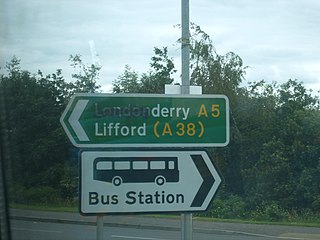
The A5 is a major primary route in Northern Ireland. It links the city of Derry in County Londonderry with Aughnacloy, County Tyrone via the towns of Strabane and Omagh. Just south of Aughnacloy is the border with the Republic of Ireland, where the A5 meets the N2 to Dublin. Between them the A5 and N2 are the main road link between County Donegal in the Republic and Dublin.

InterCity is the brand name given to rail services operated by Iarnród Éireann that run between Dublin and other major cities in Ireland. InterCity branding is also used in other European countries by unaffiliated organizations.

Midlands Gateway, also known as Lake-Counties Gateway, is an area centered between the Irish airports of Dublin, Shannon, and Knock. The principal urban centres in the Midlands Gateway include Athlone, Tullamore and Mullingar. The background to the Midlands Gateway project was the Irish government's National Spatial Strategy, launched in 2002. The counties covered in the plan include County Offaly and County Westmeath.
Main Street is a metonym used to denote a primary retail street of a village, town or small city in many parts of the world. It is usually a focal point for shops and retailers in the central business district, and is most often used in reference to retailing, socializing, and the place to go to find "common" concerns.

Willie Miller was a designer and urbanist based in Glasgow, Scotland. He was Principal of Willie Miller Urban Design, a design practice based in the West End of Glasgow. Miller studied at Glasgow School of Art, then at the Scott Sutherland School of Architecture and The Built Environment in Aberdeen, and was assistant director of Planning at Monklands District Council, prior to establishing WMUD in 1996. He died in January 2021 at the age of 70.
In Ireland, the term city has somewhat differing meanings in Northern Ireland and the Republic of Ireland.
| | This Ireland-related article is a stub. You can help Wikipedia by expanding it. |