
The National Stone Centre is a museum, an industrial heritage discovery centre and a Site of Special Scientific Interest at Wirksworth, in Derbyshire, England. [1]
The National Stone Centre is a museum, an industrial heritage discovery centre and a Site of Special Scientific Interest at Wirksworth, in Derbyshire, England. [1]
The National Stone Centre is in the middle of the Derbyshire Dales and on the edge of the Peak District National Park. It covers an area of 50 acres that contains 6 disused stone quarries, over 102 old lead mineshafts and 4 lime kilns. The centre is not far from the Derwent Valley Mills World Heritage Site. [1]
The discovery centre has a Story of Stone exhibition as well as a range of rock and mineral shops and a café. [1]
The National Stone Centre runs courses for dry stonewalling and other crafts involving stone. [1]

Bakewell is a market town and civil parish in the Derbyshire Dales district of Derbyshire, England, known for Bakewell pudding. It lies on the River Wye, 15 miles (23 km) south-west of Sheffield. It is the largest settlement and only town within the boundaries of the Peak District National Park. At the 2011 census, the population of the civil parish was 3,949. It was estimated at 3,695 in 2019. The town is close to the tourist attractions of Chatsworth House and Haddon Hall.

Bamford is a village in the Peak District, Derbyshire, England, close to the River Derwent. To the north-east is Bamford Edge, and to the north-west the Ladybower, Derwent and Howden Reservoirs. At the 2011 census, it had a population of 1,241.

The High Peak Trail is a 17-mile (27 km) trail for walkers, cyclists and horse riders in the Peak District of England. Running from Dowlow (53.2059°N 1.8349°W), near Buxton, to High Peak Junction, Cromford (53.1004°N 1.5354°W), it follows the trackbed of the former Cromford and High Peak Railway, which was completed in 1831 to carry minerals and goods between the Cromford Canal wharf at High Peak Junction and the Peak Forest Canal at Whaley Bridge.

Matlock Bath railway station serves the village of Matlock Bath in Derbyshire, England. It is a stop on the Derwent Valley Line, which connects Derby with Matlock. The station building is Grade II listed and is located 16.25 miles (26.15 km) north of Derby; it is owned by Network Rail and managed by East Midlands Railway.

Duffield Castle was a Norman Castle in Duffield, Derbyshire. The site is a scheduled monument.
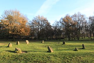
The Nine Ladies is a stone circle located on Stanton Moor in Derbyshire in the English East Midlands. The Nine Ladies is part of a tradition of stone circle construction that spread throughout much of Britain, Ireland, and Brittany during the Late Neolithic and Early Bronze Ages, over a period between 3300 and 900 BCE. The purpose of such monuments is unknown, although archaeologists speculate that the stones represented supernatural entities for the circles' builders.

Commander-in-Chief, Western Approaches was the commander of a major operational command of the Royal Navy during World War II. The admiral commanding, and his forces, sometimes informally known as 'Western Approaches Command,' were responsible for the safety of British shipping in the Western Approaches.

Longshaw Estate is an area of moorland, woodland and farmland within the Peak District National Park in Derbyshire, England.
Ecclesall Woods is an area of woodland in south-west Sheffield, South Yorkshire, England, between Abbeydale Road South and Ecclesall. It covers approximately 350 acres (1.4 km2) of mature semi-natural deciduous woodland which was previously used for timber and charcoal, and is currently managed by the city council for the benefit of wildlife and visitor access. There are two roads and over 10 miles (16 km) of public footpaths running through the woods. The Abbeydale miniature railway is also located within the woods.

Doll Tor is a stone circle just west of Stanton Moor, near the village of Birchover, Derbyshire in the English East Midlands. Doll Tor is part of a tradition of stone circle construction that spread throughout much of Britain, Ireland, and Brittany during the Late Neolithic and Early Bronze Ages, over a period between 3300 and 900 BCE. The purpose of such monuments is unknown, although archaeologists speculate that the stones represented supernatural entities for the circles' builders.

Stanton Moor is a small upland area in the Derbyshire Peak District of central northern England, lying between Matlock and Bakewell near the villages of Birchover and Stanton-in-Peak. It is known for its megaliths – particularly the Nine Ladies stone circle – and for its natural, wind-eroded sandstone pillars. The Peak District Boundary Walk runs across the moor.

The Bull Ring is a Class II henge that was built in the late Neolithic period near Dove Holes in Derbyshire, England.

Burbage Brook is an upper tributary stream of the River Derwent in the Peak District of England.

Eyam Hall is a country house within the civil parish of Eyam, Derbyshire, located to the west of St Lawrence's Church, Eyam. It is recorded in the National Heritage List for England as a Grade II* listed building.

Hafod Elwy Moor National Nature Reserve, located in the moorland above the town of Denbigh in Denbighshire, North Wales, is part of the Mynydd Hiraethog Site of Special Scientific Interest, formerly managed by the Countryside Council for Wales and now under the jurisdiction of Natural Resources Wales. Established in 1999, it comprises an 82-hectare (200-acre) patch of upland moor lying between the lakes of Llyn Brenig and Llyn Alwen. A conifer forest planted by the Forestry Commission borders the moor to the south and east.

Nine Stones Close, also known as the Grey Ladies, is a stone circle on Harthill Moor in Derbyshire in the English East Midlands. It is part of a tradition of stone circle construction that spread throughout much of Britain, Ireland and Brittany during the Late Neolithic and Early Bronze Ages, over a period between 3300 and 900 BCE. The purpose of the monument is unknown.
The Beans and Bacon mine is a disused lead mine on Bonsall Moor near the village of Bonsall, Derbyshire, England. The nearest large town is Matlock. The mine was in operation from 1920 to 1925, but workings around the mine date back to at least 1740 and some are thought to be medieval, making it of some archaeological importance. No reason has been given for the mine's unusual name, but other mines in the area include Mule Spinner, Frogs Hole, Cackle Mackle and Wanton Legs, making the name typical for the area.

Wrexham Archives and Local Studies holds the archives for the city of Wrexham. The archives are held at County Buildings, on Regent Street, Wrexham, and run by Wrexham County Borough Council as part of its Wrexham Archives and Local Studies Service. The centre was initially named after local Wrexham historian Alfred Neobard Palmer. The building is shared with Wrexham County Borough Museum and the archives opened in 2002.

Eyam Moor is a plateau-topped hill between the villages of Eyam and Hathersage in Derbyshire, in the Peak District of England. The summit of Sir William Hill is 429 metres (1,407 ft) above sea level.

Totley Moor is an open moorland hill to the west of the Sheffield suburb of Totley, in the Derbyshire Peak District. The summit is 395 metres (1,296 ft) above sea level.