
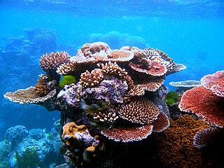
A coral reef is an underwater ecosystem characterized by reef-building corals. Reefs are formed of colonies of coral polyps held together by calcium carbonate. Most coral reefs are built from stony corals, whose polyps cluster in groups.

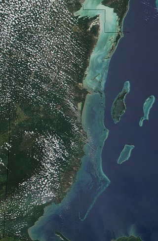
Aldabra is the world's second-largest coral atoll, lying southeast of the continent of Africa. It is part of the Aldabra Group of islands in the Indian Ocean that are part of the Outer Islands of the Seychelles, with a distance of 1,120 km (700 mi) southwest of the capital, Victoria on Mahé Island. Initially named by Arab seafarers for its harsh environment, Aldabra became a French colony dependency in the 18th century, leading to the exploitation of its natural resources, particularly giant tortoises. After passing through British hands, Aldabra faced potential military use in the 1960s, but international protests resulted in its protection. The atoll boasts unique geography, featuring the world's largest raised coral reef and a large shallow lagoon. Aldabra's history involves human impact, including failed agricultural ventures.

The Coral Sea is a marginal sea of the South Pacific off the northeast coast of Australia, and classified as an interim Australian bioregion. The Coral Sea extends 2,000 kilometres (1,200 mi) down the Australian northeast coast. Most of it is protected by the French Natural Park of the Coral Sea and the Australian Coral Sea Marine Park. The sea was the location for the Battle of the Coral Sea, a major confrontation during World War II between the navies of the Empire of Japan, and the United States and Australia.

Lord Howe Island Marine Park is the site of Australia's and the world's most southern coral reef ecosystem. The island is 10 km in length, 2 km wide and consists of a large lagoonal reef system along its leeward side, with 28 small islets along its coast. In 1999, the waters within three nautical miles of Lord Howe Island (465.45 km2) were declared a marine park under the NSW Marine Park Act 1997 to protect its unique marine biodiversity, with the park currently being managed by the New South Wales Marine Parks Authority. Both Lord Howe Island and Balls Pyramid are incorporated within the three nautical miles protected by the state marine park. Both marine parks complement the island's status as a World Heritage Site.

The biodiversity of New Caledonia is of exceptional biological and paleoecological interest. It is frequently referred to as a biodiversity hotspot. The country is a large South Pacific archipelago with a total land area of more than 18,000 square kilometres (6,900 sq mi). The terrain includes a variety of reefs, atolls, small islands, and a variety of topographical and edaphic regions on the largest island, all of which promote the development of unusually concentrated biodiversity. The region's climate is oceanic and tropical.

The New Caledonian barrier reef is a barrier reef located in New Caledonia in the South Pacific, being the longest continuous barrier reef in the world and the third largest after the Great Barrier Reef of Australia and the Mesoamerican Barrier Reef.
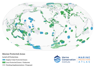
Marine protected areas (MPA) are protected areas of the world's seas, oceans, estuaries or in the US, the Great Lakes. These marine areas can come in many forms ranging from wildlife refuges to research facilities. MPAs restrict human activity for a conservation purpose, typically to protect natural or cultural resources. Such marine resources are protected by local, state, territorial, native, regional, national, or international authorities and differ substantially among and between nations. This variation includes different limitations on development, fishing practices, fishing seasons and catch limits, moorings and bans on removing or disrupting marine life. In some situations, MPAs also provide revenue for countries, potentially equal to the income that they would have if they were to grant companies permissions to fish. The value of MPA to mobile species is unknown.

Marine ecosystems are the largest of Earth's aquatic ecosystems and exist in waters that have a high salt content. These systems contrast with freshwater ecosystems, which have a lower salt content. Marine waters cover more than 70% of the surface of the Earth and account for more than 97% of Earth's water supply and 90% of habitable space on Earth. Seawater has an average salinity of 35 parts per thousand of water. Actual salinity varies among different marine ecosystems. Marine ecosystems can be divided into many zones depending upon water depth and shoreline features. The oceanic zone is the vast open part of the ocean where animals such as whales, sharks, and tuna live. The benthic zone consists of substrates below water where many invertebrates live. The intertidal zone is the area between high and low tides. Other near-shore (neritic) zones can include mudflats, seagrass meadows, mangroves, rocky intertidal systems, salt marshes, coral reefs, lagoons. In the deep water, hydrothermal vents may occur where chemosynthetic sulfur bacteria form the base of the food web.

The Papahānaumokuākea Marine National Monument (PMNM) is a World Heritage listed U.S. National Monument encompassing 583,000 square miles (1,510,000 km2) of ocean waters, including ten islands and atolls of the Northwestern Hawaiian Islands. It was created in June 2006 with 140,000 square miles (360,000 km2) and expanded in August 2016 by moving its border to the limit of the exclusive economic zone, making it one of the world's largest protected areas. It is internationally known for its cultural and natural values as follows:
The area has deep cosmological and traditional significance for living Native Hawaiian culture, as an ancestral environment, as an embodiment of the Hawaiian concept of kinship between people and the natural world, and as the place where it is believed that life originates and to where the spirits return after death. On two of the islands, Nihoa and Mokumanamana, there are archaeological remains relating to pre-European settlement and use. Much of the monument is made up of pelagic and deepwater habitats, with notable features such as seamounts and submerged banks, extensive coral reefs and lagoons.
The Belize Barrier Reef is a series of coral reefs straddling the coast of Belize, roughly 300 metres (980 ft) offshore in the north and 40 kilometres (25 mi) in the south within the country limits. The Belize Barrier Reef is a 300-kilometre (190 mi) long section of the 900-kilometre (560 mi) Mesoamerican Barrier Reef System, which is continuous from Cancún on the north-eastern tip of the Yucatán Peninsula through the Riviera Maya and down to Honduras, making it the second largest coral reef system in the world after the Great Barrier Reef in Australia. It is Belize's top tourist destination, popular for scuba diving and snorkeling and attracting almost half of its 260,000 visitors. It is also vital to the country's fishing industry.

Apo Reef is a coral reef system in the Philippines situated in the western waters of Occidental Mindoro province in the Mindoro Strait. Encompassing 34 square kilometres (13 sq mi), it is considered the world's second-largest contiguous coral reef system, and is the largest in the country. The reef and its surrounding waters are protected areas administered as the Apo Reef Natural Park (ARNP). It is one of the best known and most popular diving regions in the country, and is in the tentative list for UNESCO World Heritage Sites.

The Coral Triangle (CT) is a roughly triangular area in the tropical waters around the Philippines, Indonesia, Malaysia, Papua New Guinea, the Solomon Islands and Timor-Leste. This area contains at least 500 species of reef-building corals in each ecoregion. The Coral Triangle is located between the Pacific and Indian oceans and encompasses portions of two biogeographic regions: the Indonesian-Philippines Region, and the Far Southwestern Pacific Region. As one of eight major coral reef zones in the world, the Coral Triangle is recognized as a global centre of marine biodiversity and a global priority for conservation. Its biological resources make it a global hotspot of marine biodiversity. Known as the "Amazon of the seas", it covers 5.7 million square kilometres (2,200,000 sq mi) of ocean waters. It contains more than 76% of the world's shallow-water reef-building coral species, 37% of its reef fish species, 50% of its razor clam species, six out of seven of the world's sea turtle species, and the world's largest mangrove forest. In 2014, the Asian Development Bank (ADB) reported that the gross domestic product of the marine ecosystem in the Coral Triangle is roughly $1.2 trillion per year and provides food to over 120 million people. According to the Coral Triangle Knowledge Network, the region annually brings in about $3 billion in foreign exchange income from fisheries exports, and another $3 billion from coastal tourism revenues.
Bacalar Chico National Park and Marine Reserve (BCNPMR) is a protected area and UNESCO World Heritage Site on the northern part of Ambergris Caye in Belize.
Coral reef protection is the process of modifying human activities to avoid damage to healthy coral reefs and to help damaged reefs recover. The key strategies used in reef protection include defining measurable goals and introducing active management and community involvement to reduce stressors that damage reef health. One management technique is to create Marine Protected Areas (MPAs) that directly limit human activities such as fishing.
The Arrecifes de Cozumel National Park is off the coast of the island of Cozumel in the state of Quintana Roo, Mexico. The Cozumel reef system is part of the Mesoamerican Barrier Reef System, the second largest coral reef system in the world. Even though almost the entire island of Cozumel is surrounded by coral reefs, the park only encompasses the reefs on the south side of the island. It begins just south of the International Pier and continues down and around Punta Sur and up just a small portion of the east side of the island. The park contains both shallow and mesophotic coral reefs and extends to the 100 m depth isobar.

The Phoenix Islands Protected Area (PIPA) is located in the Republic of Kiribati, an ocean nation in the central Pacific approximately midway between Australia and Hawaii. PIPA constitutes 11.34% of Kiribati's exclusive economic zone (EEZ), and with a size of 408,250 km2 (157,630 sq mi), it is one of the largest marine protected areas (MPA) and one of the largest protected areas of any type on Earth. The PIPA was also designated as the world's largest and deepest UNESCO World Heritage Site in 2010.

Cu Lao Cham Marine Park also known as Cham Islands Biosphere Reserve is part of the eight islets of the Chàm Islands, located in the South China Sea under the administration of Tân Hiệp Commune and Hội An town, in Quảng Nam Province, Vietnam. The terrestrial and coastal ecosystems of the islands have been recognized as a global Biosphere Reserve by UNESCO on 26 May 2009 under its 'Man and the Biosphere Programme' for its rich biodiversity value. The eco system also includes the ancient Hội An, which is 20 kilometres (12 mi) away from the islands, a UNESCO World Heritage Site.
The Old Providence McBean Lagoon National Natural Park is a national park located on the northeast side of Providencia Island in the Archipelago of San Andrés, Providencia and Santa Catalina, Colombia.
The Coral reefs of Kiribati consists of 32 atolls and one raised coral island, Banaba, which is an isolated island between Nauru and the Gilbert Islands. The islands of Kiribati are dispersed over 3.5 million km2 (1.4 million sq mi) of the Pacific Ocean and straddle the equator and the 180th meridian, extending into the eastern and western hemispheres, as well as the northern and southern hemispheres. 21 of the 33 islands are inhabited. The groups of islands of Kiribati are:

Protected areas of Solomon Islands include marine protected areas that encompass coral reefs, lagoons, and seagrass meadows. East Rennell, which includes Lake Tegano, is the only area in the Solomon Islands listed by UNESCO as a World Heritage Site. As of April 2024, the Solomons have not nominated any wetlands under the Convention on Wetlands of International Importance.
