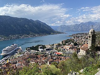
Kotor, historically known as Cattaro, is a coastal town in Montenegro. It is located in a secluded part of the Bay of Kotor. The city has a population of 13,510 and is the administrative center of Kotor Municipality.

The Bay of Kotor, also known as the Boka, is a winding bay of the Adriatic Sea in southwestern Montenegro and the region of Montenegro concentrated around the bay. It is also the southernmost part of the historical region of Dalmatia. At the entrance to the Bay there is Prevlaka, a small peninsula in southern Croatia. The bay has been inhabited since antiquity. Its well-preserved medieval towns of Kotor, Risan, Tivat, Perast, Prčanj and Herceg Novi, along with their natural surroundings, are major tourist attractions. The Natural and Culturo-Historical Region of Kotor was designated a UNESCO World Heritage Site in 1979. Its numerous Orthodox and Catholic churches and monasteries attract numerous religious pilgrims and other visitors.

Tivat is a coastal town in southwest Montenegro, located in the Bay of Kotor. As of 2011, its population was 9,367. Tivat is the centre of Tivat Municipality, which is the smallest municipality by area in Montenegro.

Herceg Novi is a coastal town in Montenegro located at the Western entrance to the Bay of Kotor and at the foot of Mount Orjen. It is the administrative center of the Herceg Novi Municipality with around 33,000 inhabitants. The town was founded as a fortress in 1382 by the King of Bosnia, Tvrtko I Kotromanić, and named after Saint Stephen but the name did not stick, instead it became known as Novi (transl. New), also Castelnuovo in Italian. Between 1482 and 1687 it was part of the Ottoman Empire and then from 1687 to 1797 the Albania Veneta of the Republic of Venice. It was a Catholic bishopric and remains a Latin titular see as Novi. Herceg Novi has had a turbulent past, despite being one of the youngest settlements on the Adriatic. A history of varied occupations has created a blend of diverse and picturesque architectural style in the city.

Perast is an old town in the Bay of Kotor in Montenegro. It is situated a few kilometres northwest of Kotor and is noted for its proximity to the islets of St. George and Our Lady of the Rocks.

Orjen is a transboundary Dinaric Mediterranean limestone mountain range, located between southernmost Bosnia and Herzegovina and southwestern Montenegro.

Risan is a town in the Bay of Kotor, Montenegro. It traces its origins to the ancient settlement of Rhizon, the oldest settlement in the Bay of Kotor.

Herceg Novi Municipality is one of the municipalities in southwestern Montenegro region. The administrative center is Herceg Novi.

Kotor Municipality is one of the municipalities of Montenegro. Its administrative center is Kotor. This municipality is located in the southwest part of Montenegro, and includes 56 recognized settlements as well as the innermost portion of the Bay of Kotor.
Montenegro is one of the fastest-growing tourist destinations. In 2007, over a million tourists visited Montenegro, making some 7.3 million overnight stays. This accounted for some 480 million euros in tourism revenue in 2007. In 2015, tourism realised over 1.7 million arrivals, with a further increase in 2016. In the same year, the coastal town of Kotor was named the best city to visit by Lonely Planet, whereas the country itself is continuously included in touristic top lists. With a total of 1.8 million visitors in 2016, the nation became the 36th most popular country to travel to in Europe. Montenegro was further visited by over 2 million tourists in 2017. The Government aims to attract greenfield investments, which should make best use of undeveloped parts of the coast, such as Jaz Beach, Velika Plaža, Ada Bojana and Buljarica.
The architecture of Montenegro is a mixture of many influences, from Roman and Venetian to Ottoman and modern times.
Venetian Albania was the official term for several possessions of the Republic of Venice in the southeastern Adriatic, encompassing coastal territories primarily in present-day southern Montenegro and partially in northern Albania.
The Verige bridge is a planned bridge in Montenegro that would span the Bay of Kotor, crossing the Verige Strait at its narrowest point. It will be part of the Adriatic Highway. As of 2007, the planning stage of the bridge is completed, and construction of the bridge can begin upon the providing of the financial means. The project is estimated to cost 48.5 million US dollars. Because the Kotor Bay is a UNESCO World Heritage Site, UNESCO has had some concerns regarding this project.
The 1979 Montenegro earthquake occurred on 15 April at 06:19 UTC with a moment magnitude of 6.9 and a maximum Mercalli intensity of X (Extreme). It was the most devastating earthquake in SR Montenegro, then part of Yugoslavia, and was mostly felt along the Montenegrin and Albanian coastline. It was also felt in other parts of the country.

The fortifications of Kotor are an integrated historical fortification system that protected the medieval town of Kotor containing ramparts, towers, citadels, gates, bastions, forts, cisterns, a castle, and ancillary buildings and structures. They incorporate military architecture of Illyria, the Byzantine Empire, Venice, and Austria. Together with the old town and its natural surroundings the fortifications were inscribed in the list of World Heritage Sites in 1979 labelled Natural and Culturo-Historical Region of Kotor and represent the only such site of cultural significance in Montenegro.
The Dârjiu fortified church is a Unitarian fortified church in Dârjiu (Székelyderzs), Harghita County, in the Transylvania region of Romania. It was built by the Székely Hungarian community at a time when the area belonged to the Kingdom of Hungary. Initially Roman Catholic, it became Unitarian following the Reformation. The church is noted for its interior frescoes, and together with the surrounding village, forms part of the villages with fortified churches in Transylvania UNESCO World Heritage Site.

Venetian Works of Defence between the 16th and 17th centuries: Stato da Terra – Western Stato da Mar is a UNESCO World Heritage Site comprising six bastion forts built by the Republic of Venice on its mainland domains and its Domains of the Sea.


