Natural disasters in Japan

Last updated

Japan is the country that is most affected by natural disasters mainly due to it being in the Ring of Fire. Two out of the five most expensive natural disasters in recent history have occurred in Japan, in 1995 and 2011, costing $181 billion. Japan has also been the site of some of the 10 worst natural disasters of the 21st century. Many types of natural disasters occur in Japan such as tsunamis, floods, typhoons, earthquakes, cyclones, and even volcanic eruptions. The country has gone through thousands of years of natural disasters, [1] affecting its economy, development, and social life. Some other major disasters in Japan were more recent, such as the January 1995 Great Hanshin earthquake and the March 2011 Tōhoku earthquake and tsunami, which triggered the Fukushima Daiichi nuclear disaster.

Contents

Volcanic eruptions

Volcano at Sakura-jima Sakurajima at Sunset.jpg
Volcano at Sakura-jima

Many volcanic eruptions have taken place in Japan.

List of major volcanic eruptions

YearVolcanoDeath toll [2] [3] Note
1640 Hokkaido Komagatake about 700
1707 Mount Fuji None
1721 Mount Asama 15
1741 Oshima (Hokkaido) 1,467
1779 Sakurajima 153
1783Mount Asama1,151
1785 Aogashima 130~140
1792 Mount Unzen about 15,000
1822 Mount Usu 103
1888 Mount Bandai 461〜477 [4]
1900 Mount Adatara 72
1902 Izu Torishima 125
1914Sakurajima58~59
1926 Mount Tokachi 144
1940 Miyakejima 11
1952 Bayonnaise Rocks 31
1958 Mount Aso 12
1991Mount Unzen43
2014 Mount Ontake 63

VEI-7 Volcanic eruptions

Mount Aso 4 pyroclastic flow and the spread of Aso 4 tephra. The pyroclastic flow reaches almost the whole area of Kyushu, and volcanic ash is deposited over 15 cm in a wide area from Kyushu to southern Hokkaido. Aso-4 tephra 90-85ka.svg
Mount Aso 4 pyroclastic flow and the spread of Aso 4 tephra. The pyroclastic flow reaches almost the whole area of Kyushu, and volcanic ash is deposited over 15 cm in a wide area from Kyushu to southern Hokkaido.

There are three VEI-7 volcanoes in Japan. These are the Aira Caldera, Kikai Caldera and Aso Caldera.

Mount Aso is the largest active volcano in Japan. Mount Aso had four eruptions 300,000 to 90,000 years ago. It emitted huge amounts of volcanic ash that covered all of Kyushu and up to Yamaguchi Prefecture.

VEI 7 eruptions have happened in the following locations of Japan.
NameZoneLocationEvent / notesYears ago before 1950 (Approx.)Ejecta volume (Approx.)
Kikai Caldera Japan, Ryukyu Islands Akahoya eruption 5,300 BC7,300 [5] 170 km3
Aira Caldera Japan, Kyūshū Aira-Tanzawa ash30,000 [5] 450 km3
Aso Caldera Japan, Kyūshū Aso-4 pyroclastic flow90,000600 km3
Mount Aso Japan, Kyūshū Four large eruptions between 300,000 and 90,000 years ago.300,000600 km3

Earthquakes

Japan has had a long history of earthquake catastrophe and seismic activity. In the past twenty years, the most severe earthquake that occurred was the 2011 Tohoku earthquake and tsunami.

Japan earthquake JAPAN EARTHQUAKE 20110311.png
Japan earthquake
After an earthquake Hanshin-Awaji earthquake 1995 346.jpg
After an earthquake

List of recent earthquakes in Japan

LocationDateEstimated deaths
Hokkaido earthquake 1993, 12 July
202
Offshore Sanriku earthquake 1994, 28 December
3
Kobe earthquake 1995, 17 January
6,434
Ryukyu Islands earthquake1998, 4 May
0
Geiyo earthquake 2001, 24 March
2
Hokkaido earthquake 2003, 26 September
1
Chuetsu earthquake 2004, 23 October
40
Fukuoka earthquake 2005, 20 March
1
Miyagi earthquake 2005, 16 August
0
Kuril Islands earthquake 2006, 15 November
0
Kuril Islands earthquake 2007, 13 January
0
Noto earthquake 2007, 25 March
1
Chuetsu Offshore earthquake 2007, 16 July
11
Iwate-Miyagi Nairiku earthquake 2008, 14 June
12
Izu Islands earthquake2009, 9 August
0
Shizuoka earthquake 2009, 11 August
1
Ryukyu Islands earthquake2010, 26 February
1
Bonin Islands earthquake2010, 21 December
0
Tohoku earthquake 2011, 11 March
15,881
Miyagi earthquake aftershock 2011, 7 April
4
Fukushima earthquake 2011, 11 April
6
Fukushima earthquake aftershock2011, 10 July
0
Izu Islands earthquake 2012, 1 January
0
Kamaishi earthquake 2012, 7 December
3
Chiba earthquake 2012, 14 March
1

Mudslides

A mudslide, or mudflow, occurs when rocks, sand, and earth are loosened and fall from hills and mountains due to earthquake, rain or snow. In Japan, over two-thirds of the land is mountainous and therefore prone to mudslides. [6]

Major mudslide events

Japan has experienced several major mudslide events, often due to other natural disasters.

Mount Ontake

On September 14, 1984, the Otaki earthquake (magnitude 6.8) in Nagano Prefecture, Japan, caused a major mudslide on the south face of Mount Ontake, which reached speeds of 80~100 km/h. [7]  Heavy rain over several days prior to the quake contributed to causing the mudslide, known as “Ontake Kuzure,” which took the lives of 29 people. After the disaster, barriers against mudslide were erected in nine locations at the foot of Mt. Ontake. [8]

Wakayama & Nara

In September 2011, Tropical Storm Talas (2011), which formed and was named on August 25, made landfall over Japan, bringing heavy rain to the mountainous Kii Peninsula, and causing a mudslide, called “Shinsohokai,” in Wakayama and Nara. "Shinsohokai" means that not only soil collapses, but also bedrock. In this case, houses were covered with earth and sand from the mudslide and there were many injured and killed. [9]

Hiroshima

In June 2010, Hiroshima experienced heavy rains which caused severe damage, including mudslides and river floods; Shōbara had 64 mm rain in an hour and Hiroshima had 30–50 mm on June 12, 20-40mm on the 13th and 20-50mm on the 14th. Five people were killed and six injured; 1,787 houses were destroyed. [10]

Floods

Floods and tsunamis are imbedded in Japanese culture and history. Southern parts of some regions are under sea level like Kyushu, Shikoku and Okinawa. Rising oceans are also making the Tokyo metropolitan area, home to 38 million people, vulnerable to storm surges. [11] Years of pumping up groundwater have caused some parts of the city to sink nearly 5 meters over the past century. This means that large parts of Tokyo are now below sea level and are only protected by outdated dikes. [12]

With a population of 127 million, the population density is very high. Most residential and industrial areas are located in low-lying areas, along rivers; these areas are very vulnerable to river flooding and flash floods. According to a 1985 study, 49 percent of the population and 75 percent of businesses are located in flood-prone areas. Given population growth in the Kanto Plain, where Japan's second-longest river, the Tone, is located, these shares are likely higher today. Water pushed to shore by strong winds or typhoons and coinciding with tide can cause significant sea level rise. These kinds of situations are then called a storm surge. In addition, precipitation is an increasing cause of flooding in Japan. [13]

Flood management

Flood management has been important in Japan for generations. The first form of flood management dates back to the 4th century when the Manda Levee (embankment) was built at the Yodo River. Here a narrow path runs along the old river near the inhabited areas. Today there is even a monument. [14] Japan has many large-scale projects to protect its inhabitants from the water. For example, there is a lot of emphasis on breaking high waves and a lot of research is being done into the behavior of tsunamis. [15] After the devastating tsunami of 2011, the Japanese government decided to protect all vulnerable villages and towns along the coast by building sea walls that range from 8.5 meters to 24 meters in height. As much as eleven billion is spent on building this 400-kilometer-long concrete wall. [16] Inland, flood management in Japan is also important against river flooding. Many of these projects are also recognizable to us. They are working on widening the river channels and building dikes. This is to limit the rise in a river's water level by increasing its cross-section and to prevent the land from flooding in times of flooding. They have drainage basins, which are used to temporarily store the overflow of the river during a flood and to drain it again after the risk of flooding has passed. This prevents the downstream water levels from rising. They also have pumping stations, here pumps are used to drain rainwater into the river in areas where the water level in the river is higher than the land. They also dredge in Japan. This is done to lower the water level in a river by deepening or dredging the river bed. Another important way of flood management is to create so-called shortcuts or shortcuts. The length of a river channel is shortened by straightening bends, so that flood water can flow through it quickly. And a flood management approach widely used by Japan is dams, such as the 186 meter high Kurobe Dam in Toyama. These dams are huge, so it often takes years to build them. The function of these dams is to regulate the water flow upstream at the time of a flood, so that the flow is reduced downstream. [17]

Heatwaves

Heatwaves have become increasingly common in Japan. June 2022 has seen the worst heatwave in 150 years. [18]

See also

Related Research Articles

<span class="mw-page-title-main">Geography of Japan</span>

Japan is an archipelagic country comprising a stratovolcanic archipelago over 3,000 km (1,900 mi) along the Pacific coast of East Asia. It consists of 14,125 islands. The five main islands are Hokkaido, Honshu, Kyushu, Shikoku, and Okinawa. The other 14,120 islands are classified as "remote islands" by the Japanese government. The Ryukyu Islands and Nanpō Islands are south and east of the main islands.

<span class="mw-page-title-main">Ōtaki, Nagano</span> Village in Chūbu, Japan

Ōtaki is a village located in Nagano Prefecture, Japan. As of 1 April 2019, the village had an estimated population of 753 in 378 household, and a population density of 2.4 persons per km². The total area of the village is 310.82 square kilometres (120.01 sq mi). At present, Ōtaki's land area is 95% forestland; 86% of which is designated national forest.

<span class="mw-page-title-main">Mount Ontake</span> Volcanic mountain on the island of Honshu, Japan

Mount Ontake, also referred to as Mount Kiso Ontake, is the 14th highest mountain and second highest volcano in Japan at 3,067 m (10,062 ft). It is included in Kyūya Fukada's 1964 100 Famous Japanese Mountains.

The following lists events that happened during 2000 in Japan. It corresponds to the year Heisei 12 in the Japanese calendar.

<span class="mw-page-title-main">1948 Fukui earthquake</span>

The 1948 Fukui earthquake occurred in Fukui Prefecture, Japan. The magnitude 6.8 quake struck at 4:13:31 p.m.(JDT) on June 28, 1948. The quake's hypocenter was approximately 10 km north-northeast of Fukui, in the present-day neighborhood of Maruoka, Sakai City. The strongest shaking occurred in the city of Fukui, where it was recorded as 6 on the Japan Meteorological Agency seismic intensity scale.

The 1964 Niigata earthquake struck at 13:01 local time on 16 June with a magnitude of either 7.5 or 7.6. The epicenter was on the continental shelf off the northwest coast of Honshu, Japan, in Niigata Prefecture, about 50 kilometres (31 mi) north of the city of Niigata. The earthquake caused liquefaction over large parts of the city.

<span class="mw-page-title-main">1984 Nagano earthquake</span> Earthquake in Japan

The 1984 Nagano earthquake hit the western part of Nagano Prefecture, Japan on September 14, 1984, at 08:48 local time. Registering a magnitude of Ms 6.3, the earthquake destroyed Otaki, and triggered major landslides. The earthquake left at least 29 people dead or missing, making it the deadliest earthquake in 1984.
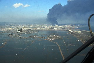
<span class="mw-page-title-main">2011 Tōhoku earthquake and tsunami</span> Megathrust earthquake off Japans east coast

On 11 March 2011, at 14:46 JST, a Mw 9.0–9.1 undersea megathrust earthquake occurred in the Pacific Ocean, 72 km (45 mi) east of the Oshika Peninsula of the Tōhoku region. It lasted approximately six minutes, causing a tsunami. It is sometimes known in Japan as the "Great East Japan Earthquake", among other names. The disaster is often referred to by its numerical date, 3.11.

A potent magnitude 6.6 Mw intraplate aftershock occurred at 17:16 JST (08:16 UTC) on 11 April, in the Hamadōri region of Fukushima, Japan. With a shallow focus of 13 km (8.1 mi), the earthquake was centred inland about 36 km (22 mi) west of Iwaki, causing widespread strong to locally severe shaking. It was one of many aftershocks to follow the 11 March Tōhoku earthquake, and the strongest to have its epicentre located inland.

<span class="mw-page-title-main">2001 Geiyo earthquake</span> Earthquake in Japan

The 2001 Geiyo earthquake occurred with a moment magnitude of 6.7 on March 24 at 15:27 local time near Hiroshima, Japan. One person in Hiroshima and one person in Ehime were reported dead. About 3,700 buildings were damaged in the Hiroshima area. Liquefaction was observed in Hiroshima and Ehime. Power outages occurred in the prefectures of Hiroshima, Ehime, Okayama, Yamaguchi, and Kōchi. The maximum intensity was shindo lower 6 in Hiroshima. This earthquake could be felt along the eastern and southern coasts of South Korea.

This article describes the Japan Meteorological Agency (JMA) severe weather terminology. The JMA defines precise meanings for nearly all its weather terms as the Information for Severe Weather Preparation. This article describes JMA terminology and related JMA weather scales. Some terms may be specific to certain regions.

The 1968 Tokachi earthquake occurred on May 16 at 0:49 UTC in the area offshore of Aomori and Hokkaido. The magnitude of this earthquake was put at Mw 8.3. The intensity of the earthquake reached shindo 5 in Aomori, Aomori and Hakodate, Hokkaido.

<span class="mw-page-title-main">2014 Hiroshima landslides</span> Natural disaster in Japan

On 20 August 2014, Hiroshima Prefecture in Japan was struck by a series of landslides following heavy rain. The rain triggered 166 slope failures which included 107 debris flows and 59 shallow slides. The landslides hit residential areas including Kabe, Asakita Ward, Yagi, Yamamoto, Midorii, and Asaminami Ward. Of these areas, the Asakita and Asaminami Wards in Northern Hiroshima were hit the hardest.

<span class="mw-page-title-main">2016 Kumamoto earthquakes</span> Earthquake in Japan

The 2016 Kumamoto earthquakes were a series of earthquakes, including a magnitude 7.0 mainshock which struck at 01:25 JST on April 16, 2016 beneath Kumamoto City of Kumamoto Prefecture in Kyushu Region, Japan, at a depth of about 10 kilometres (6.2 mi), and a foreshock earthquake with a magnitude 6.2 at 21:26 JST (12:26 UTC) on April 14, 2016, at a depth of about 11 kilometres (6.8 mi).

The following is an overview of the year 2018 in Japan.

<span class="mw-page-title-main">1847 Zenkoji earthquake</span>

The 1847 Zenkoji earthquake occurred at about 21:30 local time on 8 May at Nagano, Japan. It had a magnitude of 7.4 on the surface wave magnitude scale. It caused the destruction of many houses in Nagano and at least 8,600 people were killed. The earthquake triggered many landslides, the largest of which dammed the Sai River. 19 days later, the failure of this earthquake dam caused a flood that destroyed many more houses and killed 35 people.

<span class="mw-page-title-main">2018 Japan floods</span> Heavy rain disaster that occurred in July 2018 in Japan

In late June through mid-July 2018, successive heavy downpours in southwestern Japan resulted in widespread, devastating floods and mudflows. The event is officially referred to as Heisei san-jū-nen shichi-gatsu gōu by the Japan Meteorological Agency. As of 20 July, 225 people were confirmed dead across 15 prefectures with a further 13 people reported missing. More than 8 million people were advised or urged to evacuate across 23 prefectures. It is the deadliest freshwater flood-related disaster in the country since the 1982 Nagasaki flood when 299 people died.

<span class="mw-page-title-main">1982 Nagasaki flood</span>

The 1982 Nagasaki flood was caused by a cloudburst that occurred mainly in Nagasaki, Japan in July 1982.

<span class="mw-page-title-main">2014 Nagano earthquake</span> Earthquake in Japan

On November 22, 2014, at 22:08 local time, an earthquake struck southeast of Hakuba, Nagano Prefecture. It had a magnitude of 6.2 Mw according to the United States Geological Survey, with a maximum intensity assigned IX (Violent) on the Modified Mercalli intensity scale. According to the Japan Meteorological Agency, it is recorded as 6.7 MJMA and at its peak intensity at Shindo 6 Lower on the Japan Meteorological Agency seismic intensity scale. The earthquake did not result in any deaths, however 41 people sustained mild to severe injuries.

<span class="mw-page-title-main">2022 Fukushima earthquake</span> Severe off-shore earthquake near Fukushima, Japan

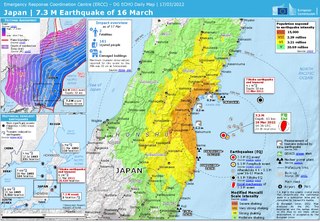
On March 16, 2022, at 23:36 JST, a strong earthquake struck off the coast of Fukushima, Japan. The earthquake had a magnitude of 7.4 according to the Japanese Meteorological Agency (JMA), while the United States Geological Survey (USGS) gave an estimate of 7.3. Immediately after the event a 30‑cm tsunami was reported. The event is known in Japanese as Fukushima-ken Oki Jishin. As a result of this natural disaster, four people died and 247 were injured.

References

  1. "Significant Earthquake: JAPAN". National Geophysical Data Center, part of the National Environmental Satellite, Data, and Information Service run by the National Oceanic and Atmospheric Administration. Archived from the original on January 26, 2016. Retrieved February 28, 2010.
  2. "わが国の主な火山災害". www.bousai.go.jp. 内閣府 . Retrieved 2022-04-16.
  3. "図録▽日本の主な火山被害". honkawa2.sakura.ne.jp. Retrieved 2022-04-16.
  4. "過去に発生した火山災害". www.data.jma.go.jp. 気象庁 . Retrieved 2022-04-16.
  5. 1 2 Smith; et al. (2013). "Identification and correlation of visible tephras in the Lake Suigetsu SG06 sedimentary archive, Japan: chronostratigraphic markers for synchronising of east Asian/west Pacific palaeoclimatic records across the last 150 ka". Quaternary Science Reviews. 67: 121–137. doi:10.1016/j.quascirev.2013.01.026.
  6. "Japan Institute of Country-ology and Engineering". www.jice.or.jp. JICE. 2007. Retrieved 2015-05-25.
  7. "Naganoken Seibu Jishin (The earthquake which hit Nagano prefecture)". www.jma-net.go.jp. Matsuhiro Seismological Observatory. Archived from the original on 2015-10-01. Retrieved 2015-05-25.
  8. 長野県土木部砂防課 (1995). "Naganoken Seibu Jishin (The earthquake which hit Nagano prefecture)". Sabo Gakkaishi. 48 (4): 66–68. doi:10.11475/sabo1973.48.4_66.
  9. "Kii Peninsula mudslide flooding". www.asahi.com. Asahi Sinbun DIGITAL. Retrieved 2015-05-25.
  10. "Hiroshima Crisis-Management Department Crisis-Management Division". BOUSAI. Retrieved 2015-05-25.
  11. "Global Flood Map | World Wide Map of Potential Flooding". globalfloodmap.org. Retrieved 2020-12-11.
  12. "How Tokyo is preparing for flooding" . The Independent. 2017-10-18. Archived from the original on 2022-06-18. Retrieved 2020-12-11.
  13. "OECD Reviews of Risk Management Policies. Japan - OECD". www.oecd.org. Retrieved 2020-12-11.
  14. "Jirej pamphlet".
  15. Peters, Martijn (2018-10-30). "Japan, het voorbeeld van én voor het Nederland van morgen?". Medium. Retrieved 2020-12-11.
  16. Visser, Jeroen (December 5, 2018). "In Japan verdwijnt het uitzicht op zee achter een tsunamimuur". Volkskrant Kijk Verder (in Dutch). Retrieved 2020-12-11.
  17. "NARBO - Network of Asian River Basin Organizations". www.narbo.jp. Retrieved 2020-12-11.
  18. "Japan swelters in hottest temperatures for 150 years as early heatwave hits Northern Hemisphere". Sky News. Retrieved 2022-06-29.