
Hubli is a city in the Indian state of Karnataka. The twin cities Hubli–Dharwad form the second largest city in the state by area and population and the largest city in North Karnataka. Hubli is in Dharwad district of Karnataka and is the taluk headquarters of Hubli City and Hubli Rural. Although it hosts the HDMC office, the district headquarters is in Dharwad.

Dharwad, also known as Dharwar, is a city located in the northwestern part of the Indian state of Karnataka. It is the headquarters of the Dharwad district of Karnataka and forms a contiguous urban area with the city of Hubballi. It was merged with Hubballi in 1962 to form the twin cities of Hubballi-Dharwad. It covers an area of 213 km2 (82 sq mi) and is located 430 km (270 mi) northwest of Bangalore, on NH-48, between Bangalore and Pune.
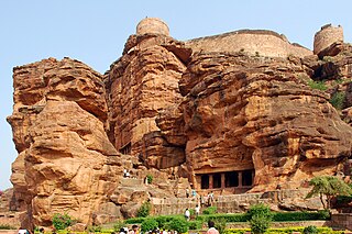
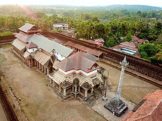
Badami, formerly known as Vātāpi, is a town and headquarters of a taluk by the same name, in the Bagalkot district of Karnataka, India. It was the regal capital of the Badami Chalukyas from 540 to 757. It is famous for its rock cut monuments such as the Badami cave temples, as well as the structural temples such as the Bhutanatha temples, Badami Shivalaya and Jambulingesvara Temple. It is located in a ravine at the foot of a rugged, red sandstone outcrop that surrounds Agastya lake.

Sirsi is a city in the Uttara Kannada district of Karnataka state in India. It was also known as "Kalyana Pattana" during the Sonda Dynasty. It is a tourist destination with evergreen forest and waterfalls and is also a commercial centre. The main businesses around the city are mostly subsistence and agriculture-based. Areca nut or betel nut, locally known as Adike, is the primary crop grown in the nearby villages, making it one of the major trading centres for areca nut. The region is also known for spices such as cardamom, pepper, betel leaves, and vanilla. The major food crop is paddy.
Dharwad or Dharawada is an administrative district of the state of Karnataka in southern India. The administrative headquarters of the district is the city of Dharwad, also known as Dharwar. Dharwad is located 425 km northwest of Bangalore and 421 km southeast of Pune, on the main highway between Chennai and Pune, the National Highway 4 (NH4).

Annigeri is a taluk of Dharwad district in the state of Karnataka, India, located 20 km west of Gadag en route to Hubli and 35 km from Hubli.
Hirekeruru is a panchayat town in Haveri district in the Indian state of Karnataka. The name "the village of the big pond". The name is pronounced as "Hee ray kay roor".The near by city is Ranebennur which is Rich commodity market in seeds & wholesale cloth market. Hirekerur taluk people daily come Ranebennur to shopping
Kalaghatagi is an administrative division, or Taluka, in the Dharwad district of the Indian state of Karnataka.

Kundgol also spelled as Kundagola is a panchayat town in Dharwad district in the Indian state of Karnataka.
Mundaragi is a municipal town in Gadag district in the Indian state of Karnataka. Mundargi is close to two district headquarters, being 36 kilometres (22 mi) from Gadag and 50 kilometres (31 mi) from Koppal. It is 99 kilometers from Gajendragad. Mundargi is also the taluka headquarter of the same name. Pin code of Mundaragi is 582118.
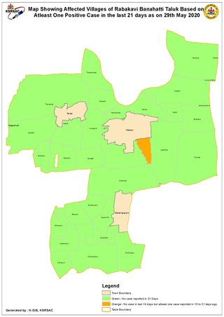
Rabkavi Banhatti is a town situated on the bank of River Krishna. It was declared a taluka by Karnataka State Govt. on 15 March 2017 and it became operational from 01-Jan-2018. It comes under Jamkhandi subdivision. It has a city municipal council in the Bagalkot district of the Indian state of Karnataka. It forms twin city along with Rabakavi, Rampur and Hosur. It is a hub of the textile business for the surrounding districts.
Shiggaon, also known as Shiggavi is a municipal town in Haveri district in the Indian state of Karnataka.
Terdal is a Municipal town in Bagalkot district in the Indian state of Karnataka.
Moodubidire is a town and taluk in Dakshina Kannada district. It lies 34 km northeast of the district headquarters, Mangalore, in Karnataka, India.
Shirahatti is a panchayat town in Gadag district in the Indian state of Karnataka.
Narendra is a village in the southern state of Karnataka, India. It is located in the Dharwad taluk of Dharwad district in Karnataka.
Saunshi is a village in the northern state of Karnataka, India. It is located in the Kundgol taluk of Dharwad district in Karnataka. largest gram Panchayat in Dharwad District.
Shelawadi or Shelavadi is a panchayat town in the southern state of Karnataka, India. It is located in the Navalgund taluk of Dharwad district in Karnataka.
Belavanaki is a village in southern state of Karnataka, India. It is located in Ron Taluka of Gadag district in Karnataka. It belongs to Belagavi Division.
Navalgund durries, geographically tagged in India, are woven durries or a type of Indian rug with geometric designs, birds, and animal designs from Navalgund in Dharwad district of Karnataka, India
