Navio Roman Fort

Last updated
Navio Roman Fort
Centurion Stone from Navio Roman Fort.jpg
Centurial Stone from Navio Roman Fort
Location Brough-on-Noe
Region Derbyshire, England
Coordinates 53°20′28″N1°43′48″W / 53.34111°N 1.73000°W / 53.34111; -1.73000 Coordinates: 53°20′28″N1°43′48″W / 53.34111°N 1.73000°W / 53.34111; -1.73000
TypeFort (Castra)
History
Periods Roman Empire
Site notes
ConditionBuried remains
Public accessFootpath
Official nameNavio Roman fort and vicus
Designated30 November 1925
Reference no.1017505

Footpath to 'Roman Station Anavio' at Batham Gate PNFS 1908 signpost to Navio Roman Fort.jpg
Footpath to 'Roman Station Anavio' at Batham Gate

Navio Roman fort overlooks a tight bend of the River Noe at Brough-on-Noe near Hope, Derbyshire, in England. Navio fort and vicus (civilian settlement) is a Scheduled Monument. [1] [2]

The town was recorded as Nauione in the Ravenna Cosmography's list of all known places in the world in about 700 AD. The entry is followed by places with which Navio had road connections: Aquis Arnemeza (Buxton), Zerdotalia (Ardotalia, later called Melandra fort, near Glossop) and Mantio (Manchester). There is also an entry for the river Anava, next to the river Dorvantium, which is considered to be the River Derwent. [3] [4] [5]

A Roman milestone was discovered in 1862 in the Silverlands district of Buxton. It is the oldest inscribed milestone found in Derbyshire. The inscription is:

TRIB POT COS II P P A NAVIONE M P XI

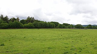
which means ‘With the tribune's power, twice consul, father of this country. From Navio 11 miles.' The milestone is on display in the Buxton Museum. [6] Navio is Latin for "on the river". The Roman name of the fort Navio was later changed to the Old English word for fort, brough . Excavations in the 1930s by Sir Ian Richmond and J.P. Gillam established the locations of the perimeters of successive forts on the same site. Navio fort was originally about 3 acres (1.2 ha) in size and built of timber and earthworks around 80 CE. It was rebuilt in stone in a rectangular form (about 90 by 105 metres (295 by 344 ft)) around 150 CE from when it was occupied for over 200 years. It was subsequently rebuilt and altered and in use until around 350 CE. The site of the fort now consists of earthwork banks and ditches around an earthen platform, buried remains and a few exposed stone slabs. Earlier excavations in 1903 by John Garstang uncovered steps into an underground stone-walled chamber below the Principia or headquarters building. A large Centurial stone and a gritstone altar were found in the fort's strong room. They are on display in the Buxton Museum. [1] [7]

Site of Navio Roman Fort at Brough-on-Noe Site of Navio Roman Fort at Brough in July 2020.jpg
Site of Navio Roman Fort at Brough-on-Noe

The Centurial stone found at Navio dates from the rebuilding of the fort in 154 CE by occupying soldiers from southwest France. The inscription on it reads:

IMP CAESARI T AEL HADR ANTONINO AVG PIO P P COH I AQVITANORVM SVB IVLIO VERO LEG AVG PR PR INSTANTE CAPITONO SCO PRAE

This translates as: "The 1st Cohort of Aquitanians under Julius Verus, the Emperor’s Governor of Britain, under the instructions of Capitonius Fuscus, Prefect of the Cohort, erected this stone in honour of the Emperor Caesar Titus Aelius Hadrianus Antoninus Augustus Pius, Father of his Country." The gritsone altar is dedicated to the goddess Arnemetia (or Arnomecta), who dwelt in the sacred waters at Buxton, and is inscribed with:

DEAE ARNOMECTE AEL MOTIO V S L L M

This translates as: "To the Goddess Arnomecta, Aelius Motio gladly, willingly and deservedly fulfilled his vow." [3]

The fort guarded the Doctor's Gate route northwest to the larger fort of Melandra (near Glossop), the Portway road to the south and the Batham Gate road (between the fort at Templeborough and the Roman spa town of Aquae Arnemetiae, modern-day Buxton). This was an important route for access to sites of lead production in the Peak District. [8] [9]

In the 1980s geophysical surveys identified the extent of the vicus (settlement adjoining the fort) to the south and east of the fort. Excavations in the 1990s determined that the vicus extended further east beyond Bradwell Brook. In 2019 excavations of the vicus uncovered foundations from stone and timber buildings. The team also found many pottery fragments, carved stone pieces, coins and a ‘ballista ball’ (ammunition for a large missile-throwing device). [3] [10] In 1929 a denarius (a silver coin) of Vespasian's sixth consulate (AD 75) was found nearby at Hope Cement Works. [11]

Related Research Articles

<span class="mw-page-title-main">Roman sites in Great Britain</span>

There are many Roman sites in Great Britain that are open to the public. There are also many sites that do not require special access, including Roman roads, and sites that have not been uncovered.

<span class="mw-page-title-main">River Noe</span> River in England

The River Noe is a tributary of the River Derwent in Derbyshire, England. It flows approximately 12 miles (19 km) from its source, the confluence of two streams running off Kinder Scout in the Peak District, east through Edale and then southeast through the village of Hope.

<span class="mw-page-title-main">Hope, Derbyshire</span> Human settlement in England

Hope is a village and civil parish in the Derbyshire Peak District, in England. The population at the 2011 Census was 864. It lies in the Hope Valley, at the point where Peakshole Water flows into the River Noe. To the north, Win Hill and Lose Hill stand either side of the Noe.

<span class="mw-page-title-main">Canovium</span> Roman fort in Conwy, North Wales

Canovium was a fort in the Roman province of Britannia. Its site is located at Caerhun in the Conwy valley, in the county borough of Conwy, in North Wales.

<span class="mw-page-title-main">Hope Valley, Derbyshire</span> Valley in Derbyshire, England

The Hope Valley is a rural area centred on the village of Hope, Derbyshire, in the Peak District in the northern Midlands of England.

<span class="mw-page-title-main">History of Derbyshire</span> History of the county of Derbyshire in England

The history of Derbyshire can be traced back to human settlement since the last Ice Age, over 10,000 years ago. The county of Derbyshire in England dates back to the 11th century.

<span class="mw-page-title-main">Brough and Shatton</span> Human settlement in England

Brough and Shatton is a civil parish in Hope Valley in the High Peak district of Derbyshire, England. It is named for the two hamlets of Brough-on-Noe and Shatton. Brough is about 2 km, or just over 1 mile, west (upstream) of Shatton; both are on the River Noe, a tributary of the upper River Derwent. They lie within the Peak District National Park, about 15 miles west of Sheffield and 30 miles east of Manchester. According to the 2011 census, Brough and Shatton had a combined population of 136. There is a friendly rivalry between the two hamlets, which contest numerous sports competitions throughout the year.

<span class="mw-page-title-main">Aquae Arnemetiae</span> Town in Roman Britain on the site of Buxton, England

Aquae Arnemetiae was a small town in the Roman province of Britannia. The settlement was based around its natural warm springs. Today it is the town of Buxton, Derbyshire in England.

<span class="mw-page-title-main">Ardotalia</span> Roman fort in Gamesley, near Glossop in Derbyshire, England

Ardotalia is a Roman fort in Gamesley, near Glossop in Derbyshire, England.

<span class="mw-page-title-main">Bradwell, Derbyshire</span> Human settlement in England

Bradwell is a village and civil parish in the Derbyshire Peak District of England. The population of the civil parish taken at the 2011 Census was 1,416. It lies south of the main body of the Hope Valley but is usually included among its settlements.

<span class="mw-page-title-main">Bremia (fort)</span>

Bremia is the name of the Roman fort in Llanio, West Wales. It is in Llanddewi Brefi community area, south-west of Tregaron, in Ceredigion. The fort was built by the Romans around AD 75 and was in use to AD 120 in Roman Wales. The fort was situated on Sarn Helen, a Roman road leading north from the fort at Dolaucothi. Five inscribed stones have been found within the fort and surrounding military settlement. Two of these have inscriptions which show the garrison to include to a cohort from the Asturias, northern Spain. Amongst the excavations on the site, is the bathhouse. The bathhouse and fort are scheduled monuments, giving them statutory protection from disturbance.

<span class="mw-page-title-main">Batham Gate</span> Roman road in Derbyshire, England

Batham Gate is the medieval name for a Roman road in Derbyshire, England, which ran south-west from Templebrough on the River Don in South Yorkshire to Brough-on-Noe and the spa town of Buxton in Derbyshire. Gate means "road" in northern English dialects; the name therefore means "road to the bath town".

<span class="mw-page-title-main">Mais (Bowness)</span> Roman fort in Cumbria, England

Maia, or Mais, in Cumbria, England was a Roman fort on Hadrian's Wall, and was the last fort at the western end of the Wall, overlooking the Solway Firth.

<span class="mw-page-title-main">Cramond Roman Fort</span> Roman fort in Edinburgh, Scotland

Cramond Roman Fort is a Roman-Era archaeological site at Cramond, Edinburgh, Scotland. The settlement may be the "Rumabo" listed in the 7th-century Ravenna Cosmography. The fort was established around 140 AD and occupied until around 170, with a further period of occupation from around 208 to 214. Among the many archaeological finds, one of the most famous is a sculpture known as the Cramond Lioness.

<span class="mw-page-title-main">The Street (Derbyshire)</span>

The Street is the medieval name of the Roman road that ran across the high limestone plateau of central Derbyshire from the spa town of Buxton southeast towards modern Derby. The line of the road can be traced from surviving features, confirmed by archaeology, from Buxton as far as Longcliffe just north of Brassington. It is believed that from Brassington the road ran eastwards to Wirksworth and there joined another road which crossed the Derwent at Milford and ran on the east bank of the Derwent and can be traced to the northern suburbs of Derby to Little Chester, the site of the Roman settlement of Derventio. The 1723 map of Brassington Moor shows The Street road from Buxton through Pikehall up to the Upper Harborough Field Gate, leading onto Manystones Lane & Brassington Lane towards Wirksworth. In records from 1613 the road from Brassington to Wirksworth is called 'Highe Streete'.

<span class="mw-page-title-main">Lutudarum</span> Town in Roman Britain in mid-Derbsyhire

Lutudarum was a town in the Roman province of Britannia, in the area that is now mid-Derbyshire. The settlement is believed to have been at either Wirksworth or nearby Carsington, although Matlock and Cromford are other candidates. The town was recorded as Lutudaron between Derventio and Veratino (Rocester) in the Ravenna Cosmography's list of all known places in the world in about 700 AD.

<span class="mw-page-title-main">Staden, Derbyshire</span> Human settlement in England

Staden is a small hamlet on the southern outskirts of Buxton, Derbyshire, lying between Harpur Hill and Cowdale. It was occupied in Neolithic, Roman and medieval times. Staden is close to the limestone hilltop of Staden Low whose summit is 367 m (1,204 ft) above sea level.

<span class="mw-page-title-main">Doctor's Gate</span> Roman Road between Glossop and the Hope Valley

Doctor's Gate is a Roman road in the Derbyshire Peak District of England, which ran between Melandra fort at Glossop and Navio fort at Brough-on-Noe. Doctor's Gate was recorded in 1627 as "Docto Talbotes Gate", named after Dr John Talbot who is attributed with improving the summit section in the late 15th century and 'gate' is derived from the Scandinavian word for road.

<span class="mw-page-title-main">Bradwell Moor</span> Hill in the Derbyshire Peak District

Bradwell Moor is a moorland hill above the village of Bradwell, Derbyshire in the Peak District. The summit is 471 metres (1,545 ft) above sea level.

<span class="mw-page-title-main">Micah Salt</span> British archaeologist

Micah Salt was a tailor and amateur archaeologist from Buxton in Derbyshire.

References

  1. 1 2 Historic England. "Navio Roman fort and vicus, Hope (1017505)". National Heritage List for England . Retrieved 17 March 2020.
  2. "Navio Roman Fort, Brough". Wonders of the Peak. 17 August 2017. Retrieved 17 March 2020.
  3. 1 2 3 Patterson, Mark (2016). Roman Derbyshire. Five Leaves Publications. pp. 134–163. ISBN   978-1910170250.
  4. "Britannia in the Ravenna Cosmography - Britanniae". www.kmatthews.org.uk. Retrieved 27 April 2020.
  5. "Britannia in the Ravenna Cosmography - Rivers". www.kmatthews.org.uk. Retrieved 27 April 2020.
  6. "Roman Buxton – Silverlands". www.wondersofthepeak.org.uk. Retrieved 4 April 2020.
  7. "The Stones of Navio". www.wondersofthepeak.org.uk. Retrieved 4 April 2020.
  8. Corble, Simon. "Navio Roman Fort at Brough, Near Hope and Castleton". Peak District Online. Retrieved 17 March 2020.
  9. Anton Shone and Dean Smart (27 January 2019). "The Street: A re-evaluation of the Roman road from Wirksworth to Buxton" (PDF). Wirksworth Roman Project. Archived from the original (PDF) on 10 July 2020. Retrieved 8 April 2020.
  10. Ball, Lucy (15 October 2019). "Ancient Roman remains found in Hope Valley". www.buxtonadvertiser.co.uk. Archived from the original on 5 June 2022. Retrieved 4 June 2020.
  11. "MDR2335 - Roman coin, Hope Cement Works, Bradwell - Derbyshire Historic Environment Record". her.derbyshire.gov.uk. Retrieved 5 June 2022.