Naylor, Georgia

Last updated
Naylor, Georgia
NaylorFD.jpg
Naylor Volunteer Fire Department with Naylor Park in background
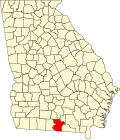
USA Georgia location map.svg
Red pog.svg
Naylor
Location in Georgia
Usa edcp location map.svg
Red pog.svg
Naylor
Location in the United States
Coordinates: 30°54′31″N83°4′42″W / 30.90861°N 83.07833°W / 30.90861; -83.07833
Country United States
State Georgia
County Lowndes
Population
 (2020)
  Total139
Time zone UTC-5 (Eastern (EST))
  Summer (DST) UTC-4 (EDT)
ZIP codes
31641

Naylor is an unincorporated community and census-designated place in Lowndes County, Georgia, United States. [1]

Contents

The 2020 census listed a population of 139. [2]

History

The community was named after Captain Naylor, a railroad agent. [3] The Georgia General Assembly incorporated Naylor as a town in 1906. [4]

Geography

Naylor is a circular area, one mile in diameter, located at the intersection of U.S. Route 84 and Georgia State Route 135. It is located approximately 9.5 miles east of Valdosta.

Demographics

Historical population
CensusPop.Note
2020 139
U.S. Decennial Census [5]
2020 [6]

Naylor was first listed as a census designated place in the 2020 U.S. Census. [6]

Naylor CDP, Georgia – Racial and ethnic composition
Note: the US Census treats Hispanic/Latino as an ethnic category. This table excludes Latinos from the racial categories and assigns them to a separate category. Hispanics/Latinos may be of any race.
Race / Ethnicity (NH = Non-Hispanic)Pop 2020 [6] % 2020
White alone (NH)10474.82%
Black or African American alone (NH)1913.67%
Native American or Alaska Native alone (NH)00.00%
Asian alone (NH)10.72%
Pacific Islander alone (NH)00.00%
Some Other Race alone (NH)10.72%
Mixed Race or Multi-Racial (NH)32.16%
Hispanic or Latino (any race)117.91%
Total139100.00%

In 2020, its population was 139. [2]

Related Research Articles

<span class="mw-page-title-main">Macon County, Georgia</span> County in Georgia, United States

Macon County is a county located in the west central portion of the U.S. state of Georgia. As of the 2020 census, the population was 12,082. The county seat is Oglethorpe.

<span class="mw-page-title-main">Evans, Georgia</span> Place in Georgia, United States

Evans is an unincorporated community and census-designated place (CDP) in Columbia County, Georgia, United States. It is a suburb of Augusta and is part of the Augusta metropolitan area. The population was 29,011 at the 2010 census, up from 17,727 at the 2000 census.

<span class="mw-page-title-main">Coleman, Georgia</span> Place in Georgia, United States

Coleman is a former incorporated city in Randolph County, Georgia, United States. It is listed as a census-designated place (CDP). The population was 149 at the 2000 census. The city was abolished by House Bill 1102 effective January 1, 2007, and no longer exists as a municipality.

<span class="mw-page-title-main">Experiment, Georgia</span> Place in Georgia, United States

Experiment is an unincorporated community and census-designated place (CDP) in Spalding County, Georgia, United States. The population was 3,233 at the 2000 census.

<span class="mw-page-title-main">Junction City, Georgia</span> Town in Georgia, United States

Junction City is a town in Talbot County, Georgia, United States. The population was 138 at the 2020 census.

<span class="mw-page-title-main">Salem, Georgia</span> Place in Georgia, United States

Salem is an unincorporated community and census-designated place (CDP) in Upson County, Georgia, United States. The population was 310 at the 2010 census.

Cataula is an unincorporated community and census-designated place (CDP) in Harris County, Georgia, United States.

<span class="mw-page-title-main">Eulonia, Georgia</span> Place in Georgia, United States

Eulonia is an unincorporated community and census-designated place (CDP) in McIntosh County in the U.S. state of Georgia. Part of the Brunswick, Georgia Metropolitan Statistical Area, it is in the Low Country between Savannah and Brunswick near Interstate 95.

<span class="mw-page-title-main">Boykin, Georgia</span> Place in Georgia, United States

Boykin is an unincorporated community and census-designated place (CDP) in Miller County, Georgia, United States. The 2020 census listed a population of 151.

<span class="mw-page-title-main">Stockton, Georgia</span> Place in Georgia, United States

Stockton is an unincorporated community and census-designated place (CDP) in Lanier County, Georgia, United States.

Bolingbroke, founded in 1867, is an unincorporated community and census-designated place (CDP) in Monroe County, Georgia, United States. It lies just north of Macon, between Interstates 475 and 75. The community is part of the Macon metropolitan statistical area.

Perkins is a census-designated place and unincorporated community in Jenkins County, Georgia, United States. As of the 2010 census it had a population of 91.

<span class="mw-page-title-main">Bristol, Georgia</span> Place in Georgia, United States

Bristol is an unincorporated community and census-designated place (CDP) in Pierce County, Georgia, United States. Bristol is located at the intersection of the concurrent Georgia State Route 15 and Georgia State Route 121, which runs north–south through Bristol, and Georgia State Route 32, which runs east–west. Bristol is 10 miles (16 km) north of Blackshear. Bristol is also known as Lightsey.

Epworth is an unincorporated community and census-designated place (CDP) in Fannin County, Georgia, United States. As of the 2010 census it had a population of 480. It lies at an elevation of 1,703 feet (519 m) in the north-central part of the county. A former name was Atalla. The ZIP code is 30541.

<span class="mw-page-title-main">Dixie, Brooks County, Georgia</span> Place in Georgia, United States

Dixie is an unincorporated community and census-designated place (CDP) in Brooks County, Georgia, United States. Dixie is located near U.S. Route 84, 6.2 miles (10.0 km) west of Quitman. Dixie has a post office with ZIP code 31629.

Empire is an unincorporated community and census-designated place in Dodge and Bleckley counties in the U.S. state of Georgia. As of the 2020 census, the CDP had a population of 319.

<span class="mw-page-title-main">Mineral Bluff, Georgia</span> Place in Georgia, United States

Mineral Bluff is a census-designated place and unincorporated community located in Fannin County in the U.S. state of Georgia. Its population was 223 as of the 2020 census. The community is situated 6 miles (10 km) northeast of the city of Blue Ridge, the county seat, 80 miles (130 km) east of Chattanooga, Tennessee, and 100 miles (160 km) north of Atlanta.

Canoochee is an unincorporated community and census-designated place (CDP) in Emanuel County, Georgia, United States. Its population was 70 as of the 2020 census.

Godfrey is an unincorporated community and census-designated place in Morgan County, in the U.S. state of Georgia. It first appeared as a CDP in the 2020 Census with a population of 108.

<span class="mw-page-title-main">Tazewell, Georgia</span> Place in Georgia, United States

Tazewell is an unincorporated community and census-designated place (CDP) in Marion County, in the U.S. state of Georgia.

References

  1. "US Gazetteer files: 2010, 2000, and 1990". United States Census Bureau. 2011-02-12. Retrieved 2011-04-23.
  2. 1 2 "Naylor CDP, Georgia". United States Census Bureau . Retrieved April 7, 2022.
  3. Krakow, Kenneth K. (1975). Georgia Place-Names: Their History and Origins (PDF). Macon, GA: Winship Press. p. 157. ISBN   0-915430-00-2.
  4. Acts and Resolutions of the General Assembly of the State of Georgia. Clark & Hines, State Printers. 1906. p. 912.
  5. "Decennial Census of Population and Housing by Decades". US Census Bureau.
  6. 1 2 3 "P2 Hispanic or Latino, and Not Hispanic or Latino by Race – 2020: DEC Redistricting Data (PL 94-171) – Naylor CDP, Georgia". United States Census Bureau .