
Willem Kieft, also Wilhelm Kieft, was a Dutch merchant and the Director of New Netherland from 1638 to 1647.
The Twelve Men was a council of citizens chosen by the residents of New Netherland to advise Director Willem Kieft on relations with the Native Americans in the wake of the murder of Claes Swits. Elected on 29 August 1641, the temporary council was the first representational form of democracy in the Dutch colony. The next two such bodies were known as the Eight Men and the Nine Men.

Paulus Hook is a community on the Hudson River waterfront in Jersey City, New Jersey. It is located one mile across the river from Manhattan. The name Hook comes from the Dutch word "hoeck", which translates to "point of land." This "point of land" has been described as an elevated area, the location of which today is bounded by Montgomery, Hudson, Dudley, and Van Vorst Streets.
The history of New York City has been influenced by the prehistoric geological formation during the last glacial period of the territory that is today New York City. The area was short inhabited by the Lenape; after initial European exploration in the 17th century, the Dutch established New Amsterdam in 1624. In 1664, the British conquered the area and renamed it New York.

Kieft's War (1643–1645), also known as the Wappinger War, was a conflict between the colonial province of New Netherland and the Wappinger and Lenape Indians in what is now New York and New Jersey. It is named for Director-General of New Netherland Willem Kieft, who had ordered an attack without the approval of his advisory council and against the wishes of the colonists. Dutch colonists attacked Lenape camps and massacred the inhabitants, which encouraged unification among the regional Algonquian tribes against the Dutch and precipitated waves of attacks on both sides. This was one of the earliest conflicts between settlers and Indians in the region. The Dutch West India Company was displeased with Kieft and recalled him, but he died in a shipwreck while returning to the Netherlands; Peter Stuyvesant succeeded him in New Netherland. Numerous Dutch settlers returned to the Netherlands because of the continuing threat from the Algonquians, and growth slowed in the colony.

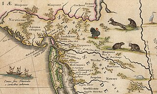
The Wecquaesgeek were a Munsee-speaking band of Wappinger people who once lived along the east bank of the Hudson River in the southwest of today's Westchester County, New York, and down into the Bronx.

Pavonia was the first European settlement on the west bank of the North River that was part of the seventeenth-century province of New Netherland in what would become the present Hudson County, New Jersey.

David Pieterszoon de Vries was a Dutch navigator from the city of Hoorn.

Vriessendael was a patroonship on the west bank of the Hudson River in New Netherland, the seventeenth century North American colonial province of the Dutch Empire. The homestead or plantation was located on a tract of about 500 acres (2.0 km2) about an hour's walk north of Communipaw at today's Edgewater. It has also been known as Tappan, which referred to the wider region of the New Jersey Palisades, rising above the river on both sides of the New York/New Jersey state line, and to the indigenous people who lived there and were part of wider group known as Lenape. It was established in 1640 by David Pietersen de Vries, a Dutch sea captain, explorer, and trader who had also established settlements at the Zwaanendael Colony and on Staten Island. The name can roughly be translated as De Vries' Valley. De Vries also owned flatlands along the Hackensack River, in the area named by the Dutch settlers Achter Col. Parts of Vriessendael were destroyed in 1643 in reprisal for the slaughter of Tappan and Wecquaesgeek Native Americans who had taken refuge at Pavonia and Corlears Hook. The patroon's relatively good relations with the Lenape prevented the murder of the plantation's residents, who were able to seek sanctuary in the main house, and later flee to New Amsterdam. The incident was one of the first of many to take place during Kieft's War, a series of often bloody conflicts with bands of Lenape, who had united in face of attacks ordered by the Director of New Netherland.
Achter Kol was the name given to the region around the Newark Bay and Hackensack River in northeastern New Jersey by the first European settlers to it and was part of the 17th century province of New Netherland, administered by the Dutch West India Company. At the time of their arrival, the area was inhabited by the Hackensack and Raritan groups of Lenape natives.
Bergen was a part of the 17th century province of New Netherland, in the area in northeastern New Jersey along the Hudson and Hackensack Rivers that would become contemporary Hudson and Bergen Counties. Though it only officially existed as an independent municipality from 1661, with the founding of a village at Bergen Square, Bergen began as a factory at Communipaw circa 1615 and was first settled in 1630 as Pavonia. These early settlements were along the banks of the North River across from New Amsterdam, under whose jurisdiction they fell.
Oratam was sagamore, or sachem, of the Hackensack Indians living in northeastern New Jersey during the period of early European colonization in the 17th century. Documentation shows that he lived an unusually long life and was quite influential among indigenous and immigrant populations.

Jan Evertsz Bout, was an early and prominent Dutch settler in the 17th century colonial province of New Netherland.
Jochem Pietersen Kuyter was an early colonist to New Netherland, and one of the first settlers of what would become Harlem on the island of Manhattan. He became an influential member of the community and served on the citizen boards known as the Twelve Men, the Eight Men and the Nine Men.
Maryn Adriansen was an early settler to New Netherland. Originally emigrating under an Indenture agreement he later became a prominent member of society. His conflict with the governor led to accusations and, eventually, acquittal. He owned property in New Amsterdam and a large plantation at Awiehaken.
Abraham Isaacsen Verplanck (1606–1690), also known as Abraham Isaacse Ver Planck, was an early and prominent settler in New Netherlands. A land developer and speculator, he was the progenitor of an extensive Verplanck family in the United States. Immigrating circa 1633, he received a land grant at Paulus Hook in 1638.
The Land of the Blacks was a village settled by people of African descent north of the wall of New Amsterdam from about 1643 to 1716. It represented an economic, legal and military modus vivendi reached with the Dutch West India Company in the wake of Kieft's War. This buffer area with the native Lenape is sometimes considered the first free African settlement in North America, although the landowners had half-free status. Its name comes from descriptions in 1640s land conveyances of white-owned properties as bordering the hereditament or freehold "of the Blacks".
The Massacre at Corlears Hook of February 25, 1643 was a colonial massacre of forty Wecquaesgeek of all ages and genders on the Lower East Side of Manhattan, perpetrated by a force led by Maryn Adriansen, acting under Willem Kieft, the Director of New Netherland.

Sapohanikan was a Lenape settlement of the Canarsee now located in close proximity to where Gansevoort Street meets Washington Street near the Hudson River in Manhattan. The people of the settlement were violently displaced under Dutch Governor Wouter van Twiller in the 1630s, who operated a tobacco plantation for the Dutch West India Company.

Konaande Kongh was a Lenape settlement of the Reckgawawanc located near what is now 98th Street and Park Avenue in East Harlem near Carnegie Hill. The settlement rested on what was once high ground, connected to the main path of Manhattan island by a branch that left the main path near 95th Street and crossed Fifth Avenue near 96th Street.

