
Manhattan is the most densely populated and geographically smallest of the five boroughs of New York City. The borough is also coextensive with New York County, one of the original counties of the U.S. state of New York. Located near the southern tip of the State of New York, Manhattan is based in the Eastern Time Zone and constitutes both the geographical and demographic center of the Northeast megalopolis and the urban core of the New York metropolitan area, the largest metropolitan area in the world by urban landmass. Over 58 million people live within 250 miles of Manhattan, which serves as New York City's economic and administrative center, cultural identifier, center of glamor, and the city's historical birthplace. Residents of the outer boroughs of New York City often refer to Manhattan as "the City".

Brooklyn is a borough of New York City, coextensive with Kings County, in the U.S. state of New York. Kings County is the most populous county in the State of New York, and the second-most-densely-populated county in the United States, behind New York County (Manhattan). Brooklyn is also New York City's most populous borough, with 2,736,074 residents in 2020. If Brooklyn were an independent city, it would be the third most populous in the U.S. after the rest of New York City and Los Angeles, and ahead of Chicago.

Harlem is a neighborhood in Upper Manhattan, New York City. It is bounded roughly by the Hudson River on the west; the Harlem River and 155th Street on the north; Fifth Avenue on the east; and Central Park North on the south. The greater Harlem area encompasses several other neighborhoods and extends west and north to 155th Street, east to the East River, and south to Martin Luther King Jr. Boulevard, Central Park, and East 96th Street.

Marble Hill is the northernmost neighborhood in the New York City borough of Manhattan. It is one of the few areas within the borough that are not located on Manhattan Island. Marble Hill was occupied as a Dutch colonial settlement in 1646, and gained its current name in 1891 because of Tuckahoe marble deposits underneath the neighborhood.

Morningside Heights is a neighborhood on the West Side of Upper Manhattan in New York City. It is bounded by Morningside Drive to the east, 125th Street to the north, 110th Street to the south, and Riverside Drive to the west. Morningside Heights borders Central Harlem and Morningside Park to the east, Manhattanville to the north, the Manhattan Valley section of the Upper West Side to the south, and Riverside Park to the west. Broadway is the neighborhood's main thoroughfare, running north–south.
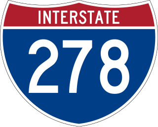
Interstate 278 (I-278) is an auxiliary Interstate Highway in New Jersey and New York in the United States. The road runs 35.62 miles (57.32 km) from US Route 1/9 (US 1/9) in Linden, New Jersey, northeast to the Bruckner Interchange in the New York City borough of the Bronx. The majority of I-278 is in New York City, where it serves as a partial beltway and passes through all five of the city's boroughs. I-278 follows several freeways, including the Union Freeway in Union County, New Jersey; the Staten Island Expressway (SIE) across Staten Island; the Gowanus Expressway in southern Brooklyn; the Brooklyn–Queens Expressway (BQE) across northern Brooklyn and Queens; a small part of the Grand Central Parkway in Queens; and a part of the Bruckner Expressway in the Bronx. I-278 also crosses multiple bridges, including the Goethals, Verrazzano-Narrows, Kosciuszko, and Robert F. Kennedy bridges.

East Harlem, also known as Spanish Harlem or El Barrio, is a neighborhood of Upper Manhattan in New York City, north of the Upper East Side and bounded by 96th Street to the south, Fifth Avenue to the west, and the East and Harlem Rivers to the east and north. Despite its name, it is generally not considered to be a part of Harlem proper, but it is one of the neighborhoods included in Greater Harlem.
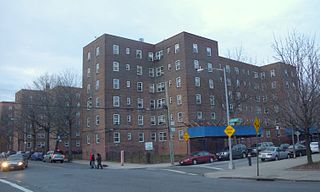
Red Hook is a neighborhood in western Brooklyn, New York City, New York, within the area once known as South Brooklyn. It is located on a peninsula projecting into the Upper New York Bay and is bounded by the Gowanus Expressway and the Carroll Gardens neighborhood on the northeast, Gowanus Canal on the east, and the Upper New York Bay on the west and south. A prosperous shipping and port area in the early 20th century, the area declined in the latter part of the century. Today it is home to the Red Hook Houses, the largest housing project in Brooklyn.

Manhattan Valley is a neighborhood in the northern part of Upper West Side in Manhattan, New York City. It is bounded by West 110th Street to the north, Central Park West to the east, West 96th Street to the south, and Broadway to the west.

Brownstone is a brown Triassic–Jurassic sandstone that was historically a popular building material. The term is also used in the United States and Canada to refer to a townhouse clad in this or any other aesthetically similar material.
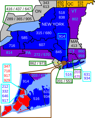
Area codes 718, 347, and 929 are telephone area codes in the North American Numbering Plan (NANP) for the New York City boroughs of the Bronx, Brooklyn, Queens, and Staten Island, as well as the Marble Hill section of Manhattan. They are part of a larger overlay plan with area code 917, which comprises all of New York City.

Manhattanville is a neighborhood in the New York City borough of Manhattan bordered on the north by 135th Street; on the south by 122nd and 125th Streets; on the west by Hudson River; and on the east by Adam Clayton Powell Jr. Boulevard and the campus of City College.

New York City, the most populous city in the United States, is composed of five boroughs: The Bronx, Brooklyn, Manhattan, Queens, and Staten Island. Each borough is coextensive with a respective county of the State of New York. The boroughs of Queens and the Bronx are also Queens County and Bronx County. The other three counties are named differently from their boroughs: Manhattan is New York County, Brooklyn is Kings County, and Staten Island is Richmond County.

Community boards of Manhattan are New York City community boards in the borough of Manhattan, which are the appointed advisory groups of the community districts that advise on land use and zoning, participate in the city budget process, and address service delivery in their district.

Since its founding in 1625 by Dutch traders as New Amsterdam, New York City has been a major destination for immigrants of many nationalities who have formed ethnic enclaves, neighborhoods dominated by one ethnicity. Freed African American slaves also moved to New York City in the Great Migration and the later Second Great Migration and formed ethnic enclaves. These neighborhoods are set apart from the main city by differences such as food, goods for sale, or even language. Ethnic enclaves provide inhabitants security in work and social opportunities, but limit economic opportunities, do not encourage the development of English speaking, and keep immigrants in their own culture.

New York City has the largest population of Italian Americans in the United States of America as well as North America, many of whom inhabit ethnic enclaves in Brooklyn, the Bronx, Manhattan, Queens, and Staten Island. New York is home to the third largest Italian population outside of Italy, behind Buenos Aires, Argentina (first) and São Paulo, Brazil (second). Over 2.6 million Italians and Italian-Americans live in the greater New York metro area, with about 800,000 living within one of the five New York City boroughs. This makes Italian Americans the largest ethnic group in the New York metro area.
The following is an alphabetical list of articles related to New York City.