Nellieburg, Mississippi

Last updated

Nellieburg, Mississippi
Lauderdale County Mississippi Incorporated and Unincorporated areas Nellieburg Highlighted.svg
Location of Nellieburg, Mississippi
Usa edcp location map.svg
Red pog.svg
Nellieburg, Mississippi
Location in the United States
Coordinates: 32°24′7″N88°46′28″W / 32.40194°N 88.77444°W / 32.40194; -88.77444
Country United States
State Mississippi
County Lauderdale
Area
[1]
  Total7.13 sq mi (18.48 km2)
  Land7.10 sq mi (18.38 km2)
  Water0.04 sq mi (0.10 km2)
Elevation
341 ft (104 m)
Population
 (2020)
  Total1,316
  Density185.46/sq mi (71.61/km2)
Time zone UTC-6 (Central (CST))
  Summer (DST) UTC-5 (CDT)
FIPS code 28-50720
GNIS feature ID0674548

Nellieburg is an unincorporated community and census-designated place (CDP) in Lauderdale County, Mississippi, United States. The population was 1,316 at the 2020 census. [2] It is a suburb of Meridian.

Contents

Geography

Nellieburg is bordered to the east by Okatibbee Creek, a south-flowing tributary of the Chickasawhay River and part of the Pascagoula River watershed. It is 6 miles (10 km) northwest of the center of Meridian, the county seat, via Mississippi Highway 19. The highway continues northwest 33 miles (53 km) to Philadelphia.

According to the United States Census Bureau, the Nellieburg CDP has a total area of 7.1 square miles (18.5 km2), of which 0.04 square miles (0.1 km2), or 0.53%, are water. [3]

Demographics

Historical population
CensusPop.Note
2020 1,316
U.S. Decennial Census [4]
Nellieburg racial composition as of 2020 [5]
(NH = Non-Hispanic) [lower-alpha 1]
RaceNumberPercentage
White (NH)89167.71%
Black or African American (NH)34526.22%
Native American or Alaska Native (NH)30.23%
Asian (NH)80.61%
Some Other Race (NH)30.23%
Mixed/Multi-Racial (NH)483.65%
Hispanic or Latino 181.37%
Total1,316

As of the 2020 United States census, there were 1,316 people, 425 households, and 347 families residing in the CDP.

As of the census [8] of 2000, there were 1,354 people, 561 households, and 407 families residing in the CDP. The population density was 103.9 inhabitants per square mile (40.1/km2). There were 580 housing units at an average density of 44.5 per square mile (17.2/km2). The racial makeup of the CDP was 84.19% White, 13.74% African American, 0.15% Native American, 0.96% Asian, 0.74% from other races, and 0.22% from two or more races. Hispanic or Latino of any race were 1.03% of the population.

There were 561 households, out of which 29.8% had children under the age of 18 living with them, 61.3% were married couples living together, 8.4% had a female householder with no husband present, and 27.3% were non-families. 23.5% of all households were made up of individuals, and 9.3% had someone living alone who was 65 years of age or older. The average household size was 2.41 and the average family size was 2.86.

In the CDP, the population was spread out, with 21.9% under the age of 18, 8.3% from 18 to 24, 26.2% from 25 to 44, 29.2% from 45 to 64, and 14.3% who were 65 years of age or older. The median age was 41 years. For every 100 females, there were 99.7 males. For every 100 females age 18 and over, there were 98.9 males.

The median income for a household in the CDP was $38,553, and the median income for a family was $48,816. Males had a median income of $35,479 versus $30,972 for females. The per capita income for the CDP was $18,266. About 11.4% of families and 14.1% of the population were below the poverty line, including 29.4% of those under age 18 and 3.8% of those age 65 or over.

Related Research Articles

<span class="mw-page-title-main">Lauderdale County, Mississippi</span> County in Mississippi, United States

Lauderdale County is a county located on the eastern border of the U.S. state of Mississippi. As of the 2020 census, the population was 72,984. The county seat is Meridian. The county is named for Colonel James Lauderdale, who was killed at the Battle of New Orleans in the War of 1812. Lauderdale County is included in the Meridian, MS Micropolitan Statistical Area.

Fox Lake Hills is an unincorporated community and census-designated place (CDP) in Lake Villa Township, Lake County, Illinois, United States. Per the 2020 census, the population was 2,684.

<span class="mw-page-title-main">Enterprise, Clarke County, Mississippi</span> Town in Mississippi, United States

Enterprise is a town in Clarke County, Mississippi, United States. The population was 526 at the 2010 census.

<span class="mw-page-title-main">Pachuta, Mississippi</span> Town in Mississippi, United States

Pachuta is a town in Clarke County, Mississippi, United States. The population was 261 at the 2010 census.

<span class="mw-page-title-main">Big Point, Mississippi</span> Census-designated place in Mississippi, United States

Big Point is an unincorporated community and census-designated place (CDP) in Jackson County, Mississippi, United States. It is part of the Pascagoula, Mississippi Metropolitan Statistical Area. Per the 2020 Census, the population was 618.

<span class="mw-page-title-main">Escatawpa, Mississippi</span> Census-designated place in Mississippi, United States

Escatawpa is an unincorporated community and census-designated place (CDP) in Jackson County, Mississippi, United States. It is part of the Pascagoula Metropolitan Statistical Area. The population was 3,254 at the 2020 census.

<span class="mw-page-title-main">Helena, Mississippi</span> Census-designated place in Mississippi, United States

Helena is an unincorporated community and census-designated place (CDP) in Jackson County, Mississippi, United States. It is part of the Moss Point Metropolitan Statistical Area. Per the 2020 Census, the population was 983.

<span class="mw-page-title-main">Latimer, Mississippi</span> Census-designated place in Mississippi, United States

Latimer is a census-designated place (CDP) in Jackson County, Mississippi, United States. It is part of the Pascagoula Metropolitan Statistical Area. The population was 6,079 at the 2010 census, up from 4,288 at the 2000 census.

<span class="mw-page-title-main">Meridian Station, Mississippi</span> Census-designated place in Mississippi, United States

Meridian Station is a census-designated place (CDP) in Lauderdale County, Mississippi, United States, corresponding to the residential portions of Naval Air Station Meridian. The population was 1,090 at the 2010 census.

<span class="mw-page-title-main">Redwater, Mississippi</span> Census-designated place in Mississippi, United States

Redwater is a census-designated place (CDP) in Leake County, Mississippi, United States. It is one of the eight communities of the Mississippi Band of Choctaw Indians Reservation, and the population is 61% Choctaw. The population was 633 at the 2010 census, up from 409 at the 2000 census.

<span class="mw-page-title-main">Standing Pine, Mississippi</span> Census-designated place in Mississippi, United States

Standing Pine is a census-designated place (CDP) in Leake County, Mississippi, United States. It is one of the eight communities of the Mississippi Band of Choctaw Indians Reservation, and the population is 94% Choctaw. The total population of the CDP was 517 at the 2020 census.

<span class="mw-page-title-main">New Hope, Mississippi</span> Census-designated place in Mississippi, United States

New Hope is a census-designated place (CDP) in Lowndes County, Mississippi, United States. As of the 2010 census, the CDP population was 3,193.

<span class="mw-page-title-main">Tucker, Mississippi</span> CDP in Mississippi, United States

Tucker is a census-designated place (CDP) in Neshoba County, Mississippi. It is one of the eight communities of the Mississippi Band of Choctaw Indians Reservation and the population is 93% Choctaw. The population was 642 at the 2020 census.

<span class="mw-page-title-main">Oakville, Missouri</span> CDP in Missouri, United States

Oakville is a census-designated place (CDP) in south St. Louis County, Missouri, United States. The population was 36,301 at the 2020 census. Oakville is 18 miles south of the city of St. Louis and borders the Mississippi and Meramec rivers; the area is part of "South County".

<span class="mw-page-title-main">Collinsville, Mississippi</span> Census-designated place in Mississippi, United States

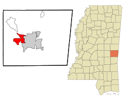
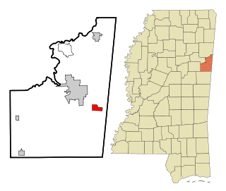
Collinsville is an unincorporated community and census-designated place (CDP) in Lauderdale County, Mississippi, United States. The population was 1,984 at the 2020 census.

<span class="mw-page-title-main">Conehatta, Mississippi</span> CDP in Mississippi, United States

Conehatta is a census-designated place (CDP) in Newton County, Mississippi. The population was 997 at the 2000 census. It is one of the eight communities included in the Mississippi Band of Choctaw Indians Reservation and the population is 76% Choctaw.

<span class="mw-page-title-main">Meridian, Pennsylvania</span> Census-designated place in Pennsylvania, United States

Meridian is a census-designated place (CDP) in Butler County, Pennsylvania, United States. The population was 3,881 at the 2010 census.

<span class="mw-page-title-main">East Hill-Meridian, Washington</span> Former CDP in Washington, United States

East Hill-Meridian is a former census-designated place (CDP) in King County, Washington. The population was 29,878 at the time of the 2010 census. The majority of the census area is now within the limits of Kent and Renton.

<span class="mw-page-title-main">Bogue Chitto, Mississippi</span> Census-designated place in Mississippi, United States

Bogue Chitto is a census-designated place (CDP) situated in Kemper and Neshoba counties, Mississippi. The population was 864 at the 2020 census. It is part of the Mississippi Band of Choctaw Indians Reservation and the population is 93% Choctaw.

Pittsfield is a census-designated place (CDP) in the town of Pittsfield in Somerset County, Maine, United States. The population was 3,217 at the 2000 census.

References

  1. Note: the US Census treats Hispanic/Latino as an ethnic category. This table excludes Latinos from the racial categories and assigns them to a separate category. Hispanics/Latinos can be of any race. [6] [7]
  1. "2020 U.S. Gazetteer Files". United States Census Bureau. Retrieved July 24, 2022.
  2. "Total Population: 2010 Census DEC Summary File 1 (P1), Nellieburg CDP, Mississippi". data.census.gov. U.S. Census Bureau. Retrieved April 2, 2020.
  3. "U.S. Gazetteer Files: 2019: Places: Mississippi". U.S. Census Bureau Geography Division. Retrieved April 2, 2020.
  4. "Census of Population and Housing". Census.gov. Retrieved June 4, 2016.
  5. "Explore Census Data". data.census.gov. Retrieved June 1, 2022.
  6. https://www.census.gov/ [ not specific enough to verify ]
  7. "About the Hispanic Population and its Origin". www.census.gov. Retrieved May 18, 2022.
  8. "U.S. Census website". United States Census Bureau . Retrieved January 31, 2008.