New Allakaket, Alaska

Last updated

New Allakaket, Alaska
CDP
New Allakaket, Alaska.jpg
USA Alaska location map.svg
Red pog.svg
New Allakaket, Alaska
Location within the state of Alaska
Coordinates: 66°33′4″N152°39′6″W / 66.55111°N 152.65167°W / 66.55111; -152.65167
CountryUnited States
State Alaska
Census Area Yukon-Koyukuk
Government
   State senator Click Bishop (R)
   State rep. Mike Cronk (R)
Area
  Total2.7 sq mi (7.1 km2)
  Land2.2 sq mi (5.8 km2)
  Water0.5 sq mi (1.3 km2)
Population
 (2010)
  Total66
  Density16/sq mi (6.2/km2)
Area code 907
FIPS code 02-53162

New Allakaket[ pronunciation? ] was a census-designated place (CDP) in Yukon-Koyukuk Census Area, Alaska, United States. The population was 66 at the 2010 census, up from 36 in 2000. In March 2015, neighboring Allakaket annexed New Allakaket. [1]

Contents

Geography

New Allakaket is located at 66°33′4″N152°39′6″W / 66.55111°N 152.65167°W / 66.55111; -152.65167 (66.551163, -152.651759). [2]

According to the United States Census Bureau, the CDP had a total area of 2.7 square miles (7.0 km2), of which, 2.2 square miles (5.7 km2) of it is land and 0.5 square miles (1.3 km2) of it was water. The total area was 18.32% water.

Demographics

Historical population
CensusPop.Note
2000 36
2010 6683.3%
U.S. Decennial Census [3]

New Allakaket first reported on the 2000 U.S. Census as a census-designated place (CDP). In 2015, it was annexed into neighboring Allakaket.

As of the census [4] of 2000, there were 36 people, 8 households, and 7 families residing in the CDP. The population density was 16.1 inhabitants per square mile (6.2/km2). There were 9 housing units at an average density of 4.0 per square mile (1.5/km2). The racial makeup of the CDP was 100.00% Native American.

There were 8 households, out of which 75.0% had children under the age of 18 living with them, 75.0% were married couples living together, 0.0% had a female householder with no husband present, and 12.5% were non-families. No households were made up of individuals, and 0.0% had someone living alone who was 65 years of age or older. The average household size was 4.50 and the average family size was 4.57.

In the town the population was spread out, with 44.4% under the age of 18, 8.3% from 18 to 24, 22.2% from 25 to 44, 19.4% from 45 to 64, and 5.6% who were 65 years of age or older. The median age was 23 years. For every 100 females, there were 125.0 males. For every 100 females age 18 and over, there were 100.0 males.

The median income for a household in the town was $30,625, and the median income for a family was $30,625. The per capita income for the CDP was $5,576. 23.5% of the population and 42.9% of families were below the poverty line. Out of the total population, 26.3% of those under the age of 18 and none of those 65 and older were living below the poverty line.

Related Research Articles

<span class="mw-page-title-main">Kongiganak, Alaska</span> CDP in Alaska, United States

Kongiganak is a census-designated place (CDP) in Bethel Census Area, Alaska, United States, and primarily sits on the eastern shore of the Kongiganak River. As of the 2010 census, the population was 439, up from 359 in 2000.

Aleneva is a census-designated place in the Kodiak Island Borough in the U.S. state of Alaska. As of the 2010 census, the population was 37, down from 68 in 2000.

Chiniak is a census-designated place (CDP) in Kodiak Island Borough, Alaska, United States. The population was 47 at the 2010 census, down from 50 in 2000.

Kodiak Station is a census-designated place (CDP) in Kodiak Island Borough, Alaska, United States. At the 2020 census the population was 1,673, up from 1,301 in 2010.

<span class="mw-page-title-main">Port Lions, Alaska</span> City in Alaska, United States

Port Lions is a city located on Kodiak Island in the Kodiak Island Borough of the U.S. state of Alaska. As of the 2010 census, the population of the city was 194, down from 256 in 2000.

Womens Bay is a census-designated place (CDP) in Kodiak Island Borough, Alaska, United States. At the 2020 census the population was 743, up from 719 in 2010. The name is correctly spelled "Womens", without an apostrophe.

<span class="mw-page-title-main">Meyers Chuck, Wrangell</span> Former census-designated place in Alaska, United States

Meyers Chuck is a former census-designated place in the City and Borough of Wrangell, Alaska, United States. The population was 21 at the 2000 census, at which time it was in the former Prince of Wales-Outer Ketchikan Census Area. On June 1, 2008, it was annexed into the newly created City and Borough of Wrangell, most of whose territory came from the former Wrangell-Petersburg Census Area.

Copperville is an unincorporated community and former census-designated place in the Copper River Census Area of the U.S. state of Alaska. The population was 179 at the 2000 United States Census, but it was consolidated into the Tazlina CDP as of the 2010 census.

<span class="mw-page-title-main">Alatna, Alaska</span> CDP in Alaska, United States

Alatna is a census-designated place (CDP) in the Yukon-Koyukuk Census Area of the Unorganized Borough in the U.S. state of Alaska. The population was 35 at the 2020 census.

<span class="mw-page-title-main">Allakaket, Alaska</span> City in Alaska, United States

Allakaket is a second class city in the Yukon-Koyukuk Census Area of the Unorganized Borough of the U.S. state of Alaska. The population was 105 at the 2010 census.

<span class="mw-page-title-main">Beaver, Alaska</span> CDP in Alaska, United States

Beaver is a census-designated place (CDP) in Yukon-Koyukuk Census Area, Alaska, United States. At the time of the 2010 census the population was 84, unchanged from 2000, however the 2020 census reported a total population of 48.

Birch Creek is a census-designated place (CDP) in Yukon-Koyukuk Census Area, Alaska, United States. The population was 33 at the 2010 census, up from 28 in 2000.

<span class="mw-page-title-main">Chalkyitsik, Alaska</span> CDP in Alaska, United States

Chalkyitsik, meaning "to fish with a hook, at the mouth of the creek", is a census-designated place (CDP) in Yukon-Koyukuk Census Area, Alaska, United States. It is located on the left (south) bank of the Black River, 45 miles northeast of Fort Yukon. At the 2010 census the population was 69, down from 83 in 2000.

<span class="mw-page-title-main">Lake Minchumina, Alaska</span> CDP in Alaska, United States

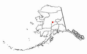
Lake Minchumina is a census-designated place (CDP) in Yukon-Koyukuk Census Area, Alaska, United States. As of the 2020 census, the population of the CDP is 30.

<span class="mw-page-title-main">Stevens Village, Alaska</span> CDP in Alaska, United States

Stevens Village is a census-designated place (CDP) in Yukon-Koyukuk Census Area, Alaska, United States. The population was 78 at the 2010 census, down from 87 in 2000.

<span class="mw-page-title-main">Plumas Eureka, California</span> Census-designated place in California, United States

Plumas Eureka is a census-designated place (CDP) in Plumas County, California, United States. The population was 320 at the 2000 census.

<span class="mw-page-title-main">Harris, Kansas</span> Unincorporated community in Anderson County, Kansas

Harris is an unincorporated community in Anderson County, Kansas, United States. As of the 2020 census, the population of the community and nearby areas was 47.

<span class="mw-page-title-main">Hartstown, Pennsylvania</span> Census-designated place in Pennsylvania, United States

Hartstown is a census-designated place (CDP) in Crawford County, Pennsylvania, United States. The population was 201 at the 2010 census, down from 246 in 2000.

<span class="mw-page-title-main">Newtown, Schuylkill County, Pennsylvania</span> CDP in Pennsylvania, United States

Newtown is a census-designated place (CDP) in Reilly Township, Schuylkill County in the U.S. state of Pennsylvania. The population was 244 at the 2000 census.

<span class="mw-page-title-main">Springfield (CDP), Vermont</span> Census-designated place in Vermont, United States

Springfield is a census-designated place (CDP) comprising the main settlement within the town of Springfield, Windsor County, Vermont, United States. The population of the CDP was 3,979 at the 2010 census, compared with 9,373 for the town as a whole.

References

  1. Robinson, Dan; Howell, David; Sandberg, Eric; Brooks, Liz (December 2020). Alaska Population Overview: 2019 Estimates (PDF) (Report). Alaska Department of Labor and Workforce Development. pp. 153–154. ISSN   1063-3790 . Retrieved February 9, 2023.
  2. "US Gazetteer files: 2010, 2000, and 1990". United States Census Bureau. February 12, 2011. Retrieved April 23, 2011.
  3. "U.S. Decennial Census". Census.gov. Retrieved June 6, 2013.
  4. "U.S. Census website". United States Census Bureau . Retrieved January 31, 2008.