
Bandelier National Monument is a 33,677-acre (13,629 ha) United States National Monument near Los Alamos in Sandoval and Los Alamos counties, New Mexico. The monument preserves the homes and territory of the Ancestral Puebloans of a later era in the Southwest. Most of the pueblo structures date to two eras, dating between 1150 and 1600 AD.

Legion State Park is public recreation area located on the north edge of the city of Louisville, Mississippi, and adjacent to Tombigbee National Forest. As Legion State Park Historic District, the state park entered the National Register of Historic Places in 1998. It is managed by the Mississippi Department of Wildlife, Fisheries and Parks.

Cumberland Mountain State Park is a state park in Cumberland County, Tennessee, in the southeastern United States. The park consists of 1,720 acres (7.0 km2) situated around Byrd Lake, a man-made lake created by the impoundment of Byrd Creek in the 1930s. The park is set amidst an environmental microcosm of the Cumberland Plateau and provides numerous recreational activities, including an 18-hole Bear Trace golf course.

Capon Chapel, also historically known as Capon Baptist Chapel and Capon Chapel Church, is a mid-19th century United Methodist church located near to the town of Capon Bridge, West Virginia, in the United States. Capon Chapel is one of the oldest existing log churches in Hampshire County, along with Mount Bethel Church and Old Pine Church.

Opened in 1933, the 6,115-acre (2,475 ha) Cacapon Resort State Park is located on the eastern slopes of Cacapon Mountain in Morgan County, West Virginia, USA. Panorama Overlook, at the southern end of the park and 2,320 feet (710 m) above sea level, is the highest point in the park and in Morgan County.

Watoga State Park is a state park located near Seebert in Pocahontas County, West Virginia. The largest of West Virginia's state parks, it covers slightly over 10,100 acres (41 km2). Nearby parks include the Greenbrier River Trail, which is adjacent to the park, Beartown State Park, and Droop Mountain Battlefield State Park. Also immediately adjacent to the park is the 9,482-acre Calvin Price State Forest. It is one of the darkest night skies of all of West Virginia State Parks.

John James Audubon State Park is located on U. S. Route 41 in Henderson, Kentucky, just south of the Ohio River. Its inspiration is John James Audubon, the ornithologist, naturalist, and painter who resided in Henderson from 1810 to 1819 when Henderson was a frontier village.

Backbone State Park is Iowa's oldest state park, dedicated in 1919. Located in the valley of the Maquoketa River, it is approximately three miles (5 km) south of Strawberry Point in Delaware County. It is named for a narrow and steep ridge of bedrock carved by a loop of the Maquoketa River originally known as the Devil's Backbone. The initial 1,200 acres (490 ha) were donated by E.M. Carr of Lamont, Iowa. Backbone Lake Dam, a relatively low dam built by the Civilian Conservation Corps (CCC) in the 1930s, created Backbone Lake. The CCC constructed a majority of trails and buildings which make up the park.

Westmoreland State Park lies within Westmoreland County, Virginia. The park extends about one and a half miles along the Potomac River and covers 1,321 acres. The Horsehead Cliffs provide visitors with a panoramic view of the Potomac River, and lower levels feature fossils and beach access. The park offers hiking, camping, cabins, fishing, boating and swimming, although mechanical issues have kept the swimming pool closed since 2021. Located on the Northern Neck Peninsula, the park is close to historical sites featuring earlier eras: George Washington's birthplace and Stratford Hall, the birthplace of Robert E. Lee.

Staunton River State Park is a state park in Virginia. One of the Commonwealth's original state parks, built by the Civilian Conservation Corps and opening in 1936, it is located along the Staunton River near Scottsburg, Virginia. It is an International Dark Sky Park.

Copper Falls State Park is a 3,068-acre (1,242 ha) state park in Wisconsin. The park contains a section of the Bad River and its tributary the Tylers Forks, which flow through a gorge and drop over several waterfalls. Old Copper Culture Indians and later European settlers mined copper in the area. The state park was created in 1929 and amenities were developed by the Civilian Conservation Corps and the Works Progress Administration. In 2005 the park was listed on the National Register of Historic Places as a site with 10 contributing properties.
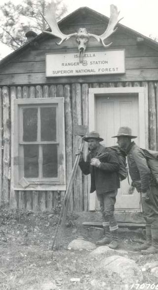
The Isabella Ranger Station is a complex of 21 buildings in Stony River Township, Minnesota, United States, near the town of Isabella. It is located on Minnesota State Highway 1 about one mile east of Isabella. The complex is listed on the National Register of Historic Places for its association with New Deal federal relief construction.

Gull Point State Park is a state park of Iowa, United States, located on West Okoboji Lake in the city of Wahpeton. It is the primary state park unit in the Iowa Great Lakes region. Two areas of the park were listed as nationally recognized historic districts on the National Register of Historic Places in 1990.

Marion County Lake is 1.5 miles (2.4 km) southeast of Marion, on the western edge of the Flint Hills region of Kansas in the United States. An unincorporated community resides around the lake. The much larger Marion Reservoir is located northwest of Marion.

The Capon Lake Whipple Truss Bridge, formerly known as South Branch Bridge or Romney Bridge, is a historic Whipple truss bridge in Capon Lake, West Virginia. It is located off Carpers Pike and crosses the Cacapon River. The bridge formerly carried Capon Springs Road over the river, connecting Capon Springs and Capon Lake.

Lacey-Keosauqua State Park is located southwest of Keosauqua, Iowa, United States. The park is located along the Des Moines River in Van Buren County. First dedicated in 1921, it is the largest state park in size in Iowa. In 1990, three areas were named nationally recognized historic districts and listed on the National Register of Historic Places.
Stillwater State Park is a state park located on Lake Groton in Groton, Vermont. The park is located in Groton State Forest close to the Groton Nature Center, Boulder Beach State Park and Big Deer State Park. The park offers camping, picnicking, and access to water-related activities on Lake Groton. The park was developed in the 1930s by crews of the Civilian Conservation Corps (CCC). It is open to the public between Memorial Day weekend and Columbus Day weekend; fees are charged for day use and camping.
Sand Bar State Park is a 15-acre (6.1 ha) state park in Milton, Vermont on the shore of Lake Champlain. The park was established in 1933.
Mount Ascutney State Park is a state park in the U.S. state of Vermont. The park entrance is located along Vermont Route 44-A near the town of Windsor in Windsor County. Operated by the Vermont Department of Forests, Parks and Recreation, a significant portion of the park is listed on the National Register of Historic Places.


