New Hampton, Missouri

Last updated
New Hampton, Missouri
Harrison County Missouri Incorporated and Unincorporated areas New Hampton Highlighted.svg
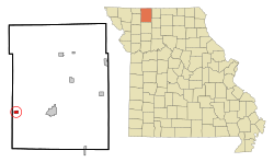
Location of New Hampton, Missouri
Coordinates: 40°15′55″N94°11′43″W / 40.26528°N 94.19528°W / 40.26528; -94.19528 Coordinates: 40°15′55″N94°11′43″W / 40.26528°N 94.19528°W / 40.26528; -94.19528
Country United States
State Missouri
County Harrison
Area
[1]
  Total0.55 sq mi (1.42 km2)
  Land0.55 sq mi (1.42 km2)
  Water0.00 sq mi (0.00 km2)
Elevation
[2]
994 ft (303 m)
Population
 (2020)
  Total228
  Density415.30/sq mi (160.44/km2)
Time zone UTC-6 (Central (CST))
  Summer (DST) UTC-5 (CDT)
ZIP code
64471
Area code 660
FIPS code 29-51860 [3]
GNIS feature ID2395197 [2]

New Hampton is a city in southwest Harrison County, Missouri, United States. The population was 228 at the 2020 census. [4]

Contents

History

New Hampton was originally called Hamptonville, and under the latter name was platted in 1869 by Hampton Cox, and named for him. [5] A post office called New Hampton has been in operation since 1881. [6]

Geography

According to the United States Census Bureau, the city has a total area of 0.55 square miles (1.42 km2), all land. [7]

Demographics

Historical population
CensusPop.Note
1890 184
1900 26141.8%
1910 45674.7%
1920 51913.8%
1930 449−13.5%
1940 412−8.2%
1950 375−9.0%
1960 289−22.9%
1970 32713.1%
1980 3589.5%
1990 320−10.6%
2000 3499.1%
2010 291−16.6%
2020 228−21.6%
U.S. Decennial Census [8]

2010 census

At the 2010 census there were 291 people in 123 households, including 80 families, in the city. The population density was 529.1 inhabitants per square mile (204.3/km2). There were 153 housing units at an average density of 278.2 per square mile (107.4/km2). The racial makup of the city was 95.5% White, 1.7% Native American, and 2.7% from two or more races. Hispanic or Latino of any race were 0.3%. [9]

Of the 123 households, 28.5% had children under the age of 18 living with them, 43.9% were married couples living together, 11.4% had a female householder with no husband present, 9.8% had a male householder with no wife present, and 35.0% were non-families. 30.9% of households were one person, and 20.3% were one person aged 65 or older. The average household size was 2.37 and the average family size was 2.90.

The median age was 38.1 years. 24.4% of residents were under the age of 18; 11.2% were between the ages of 18 and 24; 20.6% were from 25 to 44; 25.8% were from 45 to 64; and 17.9% were 65 or older. The gender makeup of the city was 49.1% male and 50.9% female.

2000 census

At the 2000 census there were 349 people in 142 households, including 92 families, in the city. The population density was 501.3 inhabitants per square mile (193.6/km2). There were 170 housing units at an average density of 244.2 per square mile (94.3/km2). The racial makup of the city was 100.00% White. Hispanic or Latino of any race were 1.72%. [3]

Of the 142 households, 26.1% had children under the age of 18 living with them, 54.9% were married couples living together, 6.3% had a female householder with no husband present, and 35.2% were non-families. 31.0% of households were one person, and 16.9% were one person aged 65 or older. The average household size was 2.46 and the average family size was 3.12.

In the city the population was spread out, with 26.4% under the age of 18, 8.0% from 18 to 24, 25.8% from 25 to 44, 19.8% from 45 to 64, and 20.1% 65 or older. The median age was 40 years. For every 100 females, there were 89.7 males. For every 100 females age 18 and over, there were 93.2 males.

The median household income was $32,917 and the median family income was $40,536. Males had a median income of $23,125 versus $16,136 for females. The per capita income for the city was $13,450. About 4.4% of families and 10.9% of the population were below the poverty line, including 11.2% of those under age 18 and 2.9% of those age 65 or over.

Notable person

Related Research Articles

<span class="mw-page-title-main">Richfield, Idaho</span> City in Idaho, United States

Richfield is a city in Lincoln County, Idaho, in the United States. The population was 482 at the 2010 census.

<span class="mw-page-title-main">Culdesac, Idaho</span> City in Idaho, United States

Culdesac is a city in Nez Perce County, Idaho, United States. The population was 380 at the 2010 census. It is part of the Lewiston, ID-WA Metropolitan Statistical Area.

<span class="mw-page-title-main">Osburn, Idaho</span> City in Shoshone County, Idaho, United States

Osburn is a city in Shoshone County, Idaho, United States. Located in the Silver Valley mining region of northern Idaho, its population was 1,555 at the 2010 census.

<span class="mw-page-title-main">Nodaway, Iowa</span> City in Iowa, United States

Nodaway is a city in Nodaway Township, Adams County, Iowa, United States. The population was 74 at the time of the 2020 census. Nodaway was incorporated in 1900.

<span class="mw-page-title-main">Van Wert, Iowa</span> City in Iowa, United States

Van Wert is a city in northern Decatur County, Iowa, United States. The population was 178 at the time of the 2020 census.

<span class="mw-page-title-main">Columbus City, Iowa</span> City in Iowa, United States

Columbus City is a city in western Louisa County, Iowa, United States. The population was 392 at the 2020 census. It is part of the Muscatine Micropolitan Statistical Area.
<span class="mw-page-title-main">Oakville, Iowa</span> City in Iowa, United States

Oakville is a city in southeasern Louisa County, Iowa, United States. The population was 200 at the time of the 2020 census. It is part of the Muscatine Micropolitan Statistical Area.

<span class="mw-page-title-main">Patterson, Iowa</span> City in Iowa, United States

Patterson is a city in Madison County, Iowa, United States. The population was 176 at the time of the 2020 census. It is part of the Des Moines–West Des Moines Metropolitan Statistical Area.

<span class="mw-page-title-main">Westphalia, Iowa</span> City in Iowa, United States

Westphalia is a city in Shelby County, Iowa, United States. The population was 126 at the time of the 2020 census.

<span class="mw-page-title-main">West Chester, Iowa</span> City in Iowa, United States

West Chester is a city in Washington County, Iowa, United States. It is part of the Iowa City, Iowa Metropolitan Statistical Area. The population was 144 at the time of the 2020 census.

<span class="mw-page-title-main">Kensett, Iowa</span> City in Iowa, United States

Kensett is a city in Worth County, Iowa, United States. The population was 257 at the time of the 2020 census. It is part of the Mason City Micropolitan Statistical Area.

<span class="mw-page-title-main">Mosby, Missouri</span> City in Missouri, United States

Mosby is a city in Clay County, Missouri, United States, along the Fishing River. The population was 101 at the 2020 census. It is part of the Kansas City metropolitan area.

<span class="mw-page-title-main">St. Thomas, Missouri</span> City in Missouri, United States

St. Thomas or Saint Thomas is a city in Cole County, Missouri, United States. The population was 222 at the 2020 census. It is part of the Jefferson City, Missouri Metropolitan Statistical Area.
<span class="mw-page-title-main">Coffey, Missouri</span> City in Missouri, United States

Coffey is a city in northern Daviess County, Missouri, United States. The population was 151 at the 2020 census.

<span class="mw-page-title-main">Morrison, Missouri</span> City in Missouri, United States

Morrison is a city in Gasconade County, Missouri, United States. The first permanent settlement in the town was made by Robert Shobe circa 1828. The population was 93 at the 2020 census.
<span class="mw-page-title-main">Weaubleau, Missouri</span> City in Missouri, United States

Weaubleau is a city in Hickory County, Missouri, United States, founded in 1867. The population was 378 at the 2020 census.

<span class="mw-page-title-main">Unity Village, Missouri</span> Village in Missouri, United States

Unity Village is a village in Jackson County, Missouri, United States, bordering Kansas City and Lee's Summit. Its population was 99 at the 2010 census. It is the world headquarters of Unity Church, which has over 2 million followers. The Unity Tower was designed by the Kansas City firm Boillot & Lauck and built in 1929 to store water. Unity Village is part of the Kansas City metropolitan area.

<span class="mw-page-title-main">Mayview, Missouri</span> City in Missouri, United States

Mayview is a city in Lafayette County, Missouri, and part of the Kansas City metropolitan area within the United States. The population was 211 at the 2010 census.

<span class="mw-page-title-main">Wood Heights, Missouri</span> City in Missouri, United States

Wood Heights is a city in western Ray County, Missouri, and part of the Kansas City metropolitan area within the United States. The population was 757 at the 2020 census.

<span class="mw-page-title-main">Whitewood, South Dakota</span> City in South Dakota, United States

Whitewood is a city in Lawrence County, South Dakota, United States. The population was 879 at the 2020 census.
References

  1. "ArcGIS REST Services Directory". United States Census Bureau. Retrieved August 28, 2022.
  2. 1 2 U.S. Geological Survey Geographic Names Information System: New Hampton, Missouri
  3. 1 2 "U.S. Census website". United States Census Bureau . Retrieved 2008-01-31.
  4. "Explore Census Data". data.census.gov. Retrieved 2021-12-16.
  5. "Harrison County Place Names, 1928–1945 (archived)". The State Historical Society of Missouri. Archived from the original on 24 June 2016. Retrieved 3 October 2016.{{cite web}}: CS1 maint: bot: original URL status unknown (link)
  6. "Post Offices". Jim Forte Postal History. Retrieved 3 October 2016.
  7. "US Gazetteer files 2010". United States Census Bureau. Archived from the original on 2012-01-25. Retrieved 2012-07-08.
  8. "Census of Population and Housing". Census.gov. Retrieved June 4, 2015.
  9. "U.S. Census website". United States Census Bureau . Retrieved 2012-07-08.