Related Research Articles

The Arthur Kill is a tidal strait between Staten Island, New York and Union and Middlesex counties, New Jersey. It is a major navigational channel of the Port of New York and New Jersey.

The Province of New Jersey was one of the Middle Colonies of Colonial America and became the U.S. state of New Jersey in 1783. The province had originally been settled by Europeans as part of New Netherland but came under English rule after the surrender of Fort Amsterdam in 1664, becoming a proprietary colony. The English renamed the province after the Bailiwick of Jersey in the English Channel. The Dutch Republic reasserted control for a brief period in 1673–1674. After that it consisted of two political divisions, East Jersey and West Jersey, until they were united as a royal colony in 1702. The original boundaries of the province were slightly larger than the current state, extending into a part of the present state of New York, until the border was finalized in 1773.

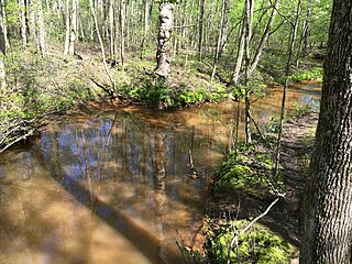
Cheesequake State Park is a 1,610-acre (2.52 sq mi) state park located in Old Bridge, Middlesex County, New Jersey, in the United States.
Riparian water rights is a system for allocating water among those who possess land along its path. It has its origins in English common law. Riparian water rights exist in many jurisdictions with a common law heritage, such as Canada, Australia, and states in the eastern United States.
Water right in water law refers to the right of a user to use water from a water source, e.g., a river, stream, pond or source of groundwater. In areas with plentiful water and few users, such systems are generally not complicated or contentious. In other areas, especially arid areas where irrigation is practiced, such systems are often the source of conflict, both legal and physical. Some systems treat surface water and ground water in the same manner, while others use different principles for each.

The Metedeconk River is a tributary of Barnegat Bay in Ocean County, New Jersey in the United States.

The Port of San Francisco is a semi-independent organization that oversees the port facilities at San Francisco, California, United States. It is run by a five-member commission, appointed by the Mayor and approved by the Board of Supervisors. The Port is responsible for managing the larger waterfront area that extends from the anchorage of the Golden Gate Bridge, along the Marina district, all the way around the north and east shores of the city of San Francisco including Fisherman's Wharf and the Embarcadero, and southward to the city line just beyond Candlestick Point. In 1968 the State of California, via the California State Lands Commission for the State-operated San Francisco Port Authority, transferred its responsibilities for the Harbor of San Francisco waterfront to the City and County of San Francisco / San Francisco Harbor Commission through the Burton Act AB2649. All eligible State port authority employees had the option to become employees of the City and County of San Francisco to maintain consistent operation of the Port of San Francisco.
The New Jersey Department of Environmental Protection (NJDEP) is a government agency in the U.S. state of New Jersey that is responsible for managing the state's natural resources and addressing issues related to pollution. NJDEP now has a staff of approximately 2,850.
The Shark River is a river in eastern New Jersey that rises in eastern Monmouth County and flows southeast for 11.7 miles (18.8 km), continuing through Neptune Township and Wall Township. The river continues towards the Shark River Inlet, an estuary that feeds into the Atlantic Ocean between Belmar and Avon-by-the-Sea.

Bayfront is an urban redevelopment project in Jersey City, New Jersey.
The Supreme Court decision in Illinois Central Railroad v. Illinois, 146 U.S. 387 (1892), reaffirmed that each state in its sovereign capacity holds title to all submerged lands within its borders and holds these lands in public trust. This is a foundational case for the public trust doctrine. The Supreme Court held a four to three split decision that the State of Illinois did not possess the authority to grant fee title to submerged lands where doing so would preclude exercise of the public right to commercial navigation and fishing in navigable waters.
The New Jersey Register of Historic Places is the official list of historic resources of local, state, and national interest in the U.S. state of New Jersey. The program is administered by the New Jersey's state historic preservation office within the New Jersey Department of Environmental Protection.

Bergen was a part of the 17th century province of New Netherland, in the area in northeastern New Jersey along the Hudson and Hackensack Rivers that would become contemporary Hudson and Bergen Counties. Though it only officially existed as an independent municipality from 1661, with the founding of a village at Bergen Square, Bergen began as a factory at Communipaw circa 1615 and was first settled in 1630 as Pavonia. These early settlements were along the banks of the North River across from New Amsterdam, under whose jurisdiction they fell.
Tidelands are the territory between the tide line of sea coasts, and lands lying under the sea beyond the low-water limit of the tide, considered within the territorial waters of a nation. The United States Constitution does not specify whether ownership of these lands rests with the federal government or with individual states. Originally little commercial value was attached to tidelands, so ownership was never firmly established, but the coastal states generally proceeded as if they were the owners. Some states, such as Mississippi, directly administer these lands under the public trust doctrine.
Morris v. United States, 174 U.S. 196 (1899), is a 5-to-2 ruling by the United States Supreme Court which held that the bed under the Potomac River between the District of Columbia and the Commonwealth of Virginia belonged to the United States government rather than nearby private landowners on the District of Columbia side.

The New York – New Jersey Line War was a series of skirmishes and raids that took place for over half a century between 1701 and 1765 at the disputed border between two American colonies, the Province of New York and the Province of New Jersey.
Garden State Equality v. Dow, 82 A. 3d 336 is a New Jersey Superior Court case holding that New Jersey's marriage laws violated the rights of same-sex couples to equal protection of the law under the New Jersey State Constitution. The ruling was issued on September 27, 2013. The Superior Court and the Superior Court, Appellate Division refused the State's request for a stay of the trial court's order, and the New Jersey Supreme Court refused to do so on a 7-0 vote. The ruling took effect on October 21, 2013. On the same day, New Jersey Governor Chris Christie dropped the State's plans to appeal, ending the denial of marriage rights to same-sex couples in New Jersey.
The Port of Paulsboro is located on the Delaware River and Mantua Creek in and around Paulsboro, in Gloucester County, New Jersey, approximately 78 miles (126 km) from the Atlantic Ocean. Traditionally one of the nation's busiest for marine transfer operations, notably for crude oil and petroleum products, such as jet fuel and asphalt, it is a port of entry with several facilities within a foreign trade zone.
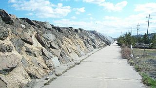
The Sea Bright–Monmouth Beach Seawall is a seawall located along the Jersey Shore in the Monmouth County, New Jersey towns of Sea Bright and Monmouth Beach. It roughly runs north-south direction along 4.7 miles (7.6 km) of the barrier spit of land along the lower Sandy Hook peninsula between the Atlantic Ocean and the Shrewsbury River estuary. The use of seawalls, groins, jetties, bulkheads, revetment, and beach nourishment since the late 1800s has made the stretch of coast one of the most heavily engineered sections of ocean shorefront in the world.
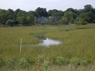
The Woodbrige River is a river in Woodbridge Township, Middlesex County, New Jersey, United States. The river is an important waterway, which frequently floods due to extreme weather caused by climate change, and is expected to increase doing so because of sea level rise. The river includes several conservation areas to protect the diversity of wildlife in the waterway, and the local government is increasingly buying out properties as part of a managed retreat to buffer other properties in the township.
References
- ↑ http://www.nj.gov/dep/landuse/download/TD_010.pdf [ bare URL PDF ]
- ↑ "Boards, Authorities and Commissions - Search". Archived from the original on 2011-07-26. Retrieved 2010-10-06.
- ↑ http://www.state.nj.us/dep/landuse/12_3.pdf , www.state.nj.us/dep/landuse/12_3.pdf
- ↑ WILLIAMS, Carol Corga (October 22, 1987). "Riparian rights stiring concern". The Asbury Park Press.