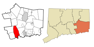
East Lyme is a town in New London County, Connecticut, United States. The town is part of the Southeastern Connecticut Planning Region. The population was 18,693 at the 2020 census. The villages of Niantic and Flanders are located in the town.
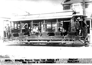
The Toronto Railway Company (TRC) was the operator of the streetcar system in Toronto between 1891 and 1921. It electrified the horsecar system it inherited from the Toronto Street Railway, the previous operator of streetcar service in Toronto. The TRC was also a manufacturer of streetcars and rail work vehicles, a few of which were built for other streetcar and radial operators.
The Toronto Suburban Railway was a Canadian electric railway operator with local routes in west Toronto, and a radial (interurban) route to Guelph.

Toronto Civic Railways (TCR) was a streetcar operator created and owned by the City of Toronto, Ontario, Canada, to serve newly annexed areas of the city that the private operator Toronto Railway Company refused to serve. When the Toronto Railway Company's franchise expired in 1921, its services were combined with those of the Toronto Civic Railways, and are now assumed by the new Toronto Transportation Commission (TTC). The first route of the TCR started operation on December 18, 1912.
The Metropolitan line in the Toronto area, operated by the Metropolitan Street Railway, started out as a local horsecar line and transformed itself into an electric radial line extending to Lake Simcoe, following an old stage coach route. In 1904, the railway was acquired by the Toronto and York Radial Railway (T&YRR) and became the T&YRR Metropolitan Division. In 1922, the City of Toronto acquired the T&YRR and contracted Ontario Hydro to manage the four T&YRR lines including the Metropolitan. In 1927, the TTC took over the operation of the Metropolitan Line to Sutton, and renamed it the Lake Simcoe line. In 1930, the TTC closed the Metropolitan Line but shortly reopened the portion between Glen Echo and Richmond Hill operating it as the North Yonge Railways until 1948.

The North Yonge Railways was a radial railway line operated by the Toronto Transportation Commission from 1930 to 1948 between Glen Echo (Toronto) and Richmond Hill. The line was created by reopening the southern portion of the TTC's Lake Simcoe radial line that had closed in 1930.
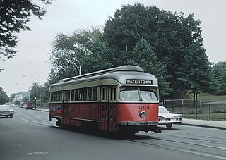
The A branch or Watertown Line was a streetcar line in the Boston, Massachusetts, area, operating as a branch of the Massachusetts Bay Transportation Authority Green Line. The line ran from Watertown through Newton Corner, Brighton, and Allston to Kenmore Square, then used the Boylston Street subway and Tremont Street subway to reach Park Street station.

The Shore Line Railway was a part of the New York, New Haven and Hartford Railroad system, running east from New Haven, Connecticut, to New London along the north shore of Long Island Sound. It is currently used for commuter service on ConnDOT's Shore Line East and regional/express service on Amtrak's high-speed Northeast Corridor.

The Shore Line Trolley Museum is a trolley museum located in East Haven, Connecticut. Incorporated in 1945, it is the oldest continuously operating trolley museum in the United States. The museum includes exhibits on trolley history in the visitors' center and offers rides on restored trolleys along its 1.5 mi (2.4 km) track as the Branford Electric Railway. In addition to trolleys, the museum also operates a small number of both trolleybuses and conventional buses.

Toronto and Scarboro' Electric Railway, Light and Power Company was established in August 1892 to provide street railway service to the Upper Beaches district within the City of Toronto, Ontario and to the neighbouring Township of Scarborough. Except for two branches, the line ran as a radial along Kingston Road.
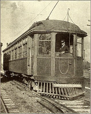
The Toronto and Mimico Electric Railway and Light Company was incorporated in 1890, and operated the Mimico radial line in the Toronto area. The line started operation in 1892 as a short suburban line that later was extended to Port Credit. In 1904, the railway was acquired by the Toronto and York Radial Railway (T&YRR) and became the T&YRR Mimico Division. In 1922, the City of Toronto acquired the T&YRR and contracted Ontario Hydro to manage the four T&YRR lines including the Mimico line. In 1927, the TTC took over the operation of the Mimico line and extended its service eastward to Roncesvalles Avenue. In 1928, the TTC double-tracked the line from Humber to Long Branch and made that portion part of the Lake Shore streetcar line. The portion beyond Long Branch to Port Credit became the Port Credit line, and continued operation as a single-track radial line until its closure on February 9, 1935.
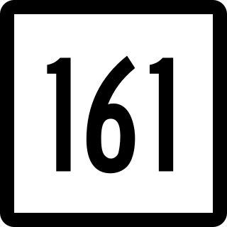
Route 161 is a state highway in southeastern Connecticut, running from the shoreline village of Niantic in East Lyme to the village of Chesterfield in Montville.

McCook Point is a public park and beach located in the village of Niantic in the town of East Lyme. It adjoins the town's Hole in the Wall Beach to its east and the private Crescent Beach to its west. Combined, the two parks encompass 21 acres of land, the bulk of which is within the section known as McCook Point Park.

The Norwich and Westerly Railway was an interurban trolley system that operated in Southeastern Connecticut during the early part of the 20th century. It operated a 21-mile line through rural territory in Norwich, Preston, Ledyard, North Stonington, and Pawcatuck, Connecticut to Westerly, Rhode Island between 1906 and 1922. For most of its length, the route paralleled what is now Connecticut Route 2.
The Shore Line Electric Railway was a trolley line along the southern coastline of Connecticut, running between New Haven and Old Saybrook with additional branches to Chester and Stony Creek. Unlike most trolley lines in New England, the Shore Line Electric was a true interurban, running large railway-style cars largely on a private right-of-way rather than on public streets. Though its main line was in operation for only 15 nonconsecutive years, the Shore Line Electric briefly acquired a substantial network of trolley lines stretching across eastern Connecticut, including the Norwich and Westerly Railway, the Groton and Stonington Street Railway, and several lines of the Connecticut Company. Most of the trolley line no longer is extant, however, the Shore Line Electric Railway Power House still stands along the mouth of the Connecticut River in Old Saybrook.

Niantic was a train station on the Northeast Corridor located in the Niantic village of East Lyme, Connecticut. Opened in the 1850s, it was rebuilt in 1899 and again in 1954 by the New Haven Railroad. It closed in 1972, then reopened from 1978 to 1981 for use by the Amtrak Beacon Hill. A new station has since been proposed to be built in Niantic to serve the Shore Line East commuter rail service.

Toronto-gauge railways are tram and rapid transit lines built to Toronto gauge, a broad gauge of 4 ft 10+7⁄8 in. This is 2+3⁄8 in (60 mm) wider than standard gauge of 4 ft 8+1⁄2 in which is by far the most common track gauge in Canada. The gauge is unique to the Greater Toronto Area and is currently used on the Toronto streetcar system and the Toronto subway, both operated by the Toronto Transit Commission. As well, the Halton County Radial Railway, a transport museum, uses the Toronto gauge so its rail line can accommodate its collection of Toronto streetcars and subway trains. Several now-defunct interurban rail systems also once used this gauge.

The Ipswich Street line was a streetcar line in Boston and Brookline, Massachusetts. The line ran on Boylston Street and Ipswich Street in the Fenway–Kenmore neighborhood, and on Brookline Avenue through what is now the Longwood Medical Area to Brookline Village.

The St. Clair Carhouse was a streetcar facility in Toronto, Ontario, Canada. It was located south of St. Clair Avenue on a parcel of land bounded by Wychwood Avenue on the east, Benson Avenue on its north side and Christie Street on the west side. It was opened by the Toronto Civic Railways in 1913, taken over by the Toronto Transportation Commission in 1921 and closed by its successor, the Toronto Transit Commission, in 1998. The carhouse was subsequently transformed into a community centre called the Wychwood Barns.
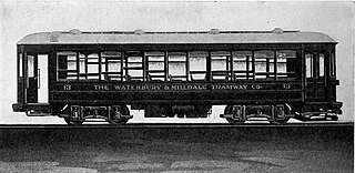
The Waterbury and Milldale Tramway was a streetcar line that operated between Waterbury and Milldale, Connecticut, United States. The line was 8.702 miles (14.00 km) long, including 1.385 miles (2.23 km) of trackage rights on a Connecticut Company line to reach downtown Waterbury. The company was chartered in June 1907 and began construction in mid-1912. It opened in stages, with the first section entering service on November 19, 1913, and the full line open on December 19, 1914. The line was soon unprofitable; the east portion was abandoned in October 1927, and the remainder in October 1933. A bus route that replaced the western portion continues to run as CTtransit route 425, operated by the Northeast Transportation Company. The Waterbury and Milldale was locally known as the "Green Line" after its green-painted streetcars, which included a pair of unique cars.


