Related Research Articles

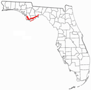
Franklin County is a county along the Gulf of Mexico in the panhandle of the U.S. state of Florida. As of the 2010 census, the population was 11,549, making it the third-least populous county in Florida. The county seat is Apalachicola.

The Au Sable River in Michigan, United States runs approximately 138 miles (222 km) through the northern Lower Peninsula, through the towns of Grayling and Mio, and enters Lake Huron at Au Sable. It is considered one of the best brown trout fisheries east of the Rockies and has been designated a blue ribbon trout stream by the Michigan Department of Natural Resources. In French, au sable literally means "at the sand." A 1795 map calls it the Beauais River.

Liberty County is a county located in the state of Florida. As of the 2010 census, the population was 8,365, making it the least populous county in Florida. Its county seat is Bristol.

Apalachicola is a city in Franklin County, Florida, United States, on the shore of Apalachicola Bay, an inlet of the Gulf of Mexico. The population was 2,231 at the 2010 census. Apalachicola is the county seat of Franklin County.
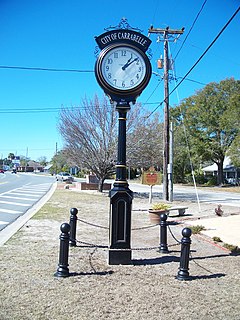
Carrabelle is a city in Franklin County along Florida's Panhandle, United States. The population was 2,778 as of the 2010 census. Carrabelle is located east of Apalachicola at the mouth of the Carrabelle River on the Gulf of Mexico.
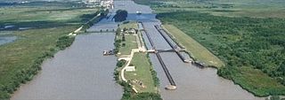
The Gulf Intracoastal Waterway is the portion of the Intracoastal Waterway located along the Gulf Coast of the United States. It is a navigable inland waterway running approximately 1,050 mi (1,690 km) from Carrabelle, Florida, to Brownsville, Texas.

The Apalachicola River is a river, approximately 112 mi (180 km) long in the state of Florida. The river's large watershed, known as the ACF River Basin, drains an area of approximately 19,500 square miles (50,505 km2) into the Gulf of Mexico. The distance to its farthest head waters in northeast Georgia is approximately 500 miles (800 km). Its name comes from the Apalachicola people, who used to live along the river.

The Flint River is a 344-mile-long (554 km) river in the U.S. state of Georgia. The river drains 8,460 square miles (21,900 km2) of western Georgia, flowing south from the upper Piedmont region south of Atlanta to the wetlands of the Gulf Coastal Plain in the southwestern corner of the state. Along with the Apalachicola and the Chattahoochee rivers, it forms part of the ACF basin. In its upper course through the red hills of the Piedmont, it is considered especially scenic, flowing unimpeded for over 200 miles (320 km). Historically, it was also called the Thronateeska River.

The Florida Panhandle is the northwestern part of the U.S. state of Florida, is a strip of land roughly 200 miles (320 km) long and 50 to 100 miles wide, lying between Alabama on the north and the west, Georgia on the north, and the Gulf of Mexico to the south. Its eastern boundary is arbitrarily defined.

Tate's Hell State Forest is 202,000 acres (819 km²) of land in Franklin and Liberty counties in Florida. The forest is located near Carrabelle off US 98 along the Gulf coast and on St. James Island. At one time, Tate's Hell supported at least 12 major habitats including: wet flatwoods, wet prairie, seepage slope, baygall, floodplain forest, floodplain swamp, basin swamp, upland hardwood forest, sandhill, pine ridges, dense titi swamp thickets and scrub. Tate's Hell State Forest is an important hydrologic area and includes a section of the New River. The park's watershed provides fresh water into the Apalachicola Bay, the Carrabelle River and the Ochlockonee River.
The Port of Apalachicola is a historic Gulf Coast port located on St. George Island in Franklin County, Florida. The Port of Apalachicola lies at the mouth of the Apalachicola River off Apalachicola Bay on the Intracoastal Waterway.

Apalachicola Bay is an estuary and lagoon located on the northwest coast of the U.S. state of Florida. The Apalachicola Bay system also includes St. George Sound, St. Vincent Sound and East Bay, covering an area of about 208 square miles (540 km2). Four islands, St. Vincent Island to the west, Cape St. George Island and St. George Island to the south, and Dog Island to the east, separate the system from the Gulf of Mexico. Water exchange occurs through Indian Pass, West Pass, East Pass and the Duer Channel. The lagoon has been designated as a National Estuarine Research Reserve and the Apalachicola River is the largest source of freshwater to the estuary. Combined with the Chattahoochee River, Flint River, and Ochlockonee River they drain a watershed of over 20,000 square miles (50,000 km2) at a rate of 19,599 cubic feet (550 m3) per second according to the United States Geological Survey in 2002.
Florida's Forgotten Coast is a registered trademark, coined in the early 1990s, by the Apalachicola Bay Chamber of Commerce. The name is most commonly used to refer to a relatively quiet, undeveloped and largely uninhabited section of coastline stretching from Mexico Beach on the Gulf of Mexico to St. Marks on Apalachee Bay in the U.S. state of Florida. The nearest major cities are Tallahassee, about 90 miles (145 km) northeast of Apalachicola, and Panama City, home of Tyndall Air Force Base, about 60 miles (95 km) to the northwest.
Spring Creek is a 76.5-mile-long (123.1 km) tributary of the Flint River in southwest Georgia in the United States.
The Battle of Flint River was a failed attack by Spanish and Apalachee Indian forces against Creek Indians in October 1702 in what is now the state of Georgia. The battle was a major element in ongoing frontier hostilities between English traders from the Province of Carolina and Spanish Florida, and it was a prelude to more organized military actions of Queen Anne's War.

The McKissack Ponds are five small ponds in the city limits of Carrabelle, Franklin County, Florida, just west – 0.3 miles (0.48 km) to 0.8 miles (1.3 km) – of the Carrabelle–Thompson Airport, on the north and south sides of Airport Road. The McKissack Ponds are owned by Franklin County.
Carrabelle River is located in Carrabelle, Florida, and flows into St. George Sound in Apalachicola Bay and the Gulf of Mexico. The area has been a base for commercial fishermen. It is home to a river festival. It is crossed by the Carrabelle River Bridge on U.S. Route 98. Upstream, the Carrabelle forks into the New River and Crooked River.

Crooked River is a waterway in Franklin County, Florida, that connects the tidal estuary of the Ochlockonee River to a junction with the tidal Carrabelle River and the New River above the town of Carrabelle, Florida. The Crooked River channel is 41 kilometres (25 mi) long, while its ends are 24 kilometres (15 mi) apart.

The Georgia Florida and Alabama (Railroad) Trail (GF&A) is section of the proposed 52-mile rail-trail from Tallahassee to Carrabelle on the Gulf of Mexico. It is part of the Georgia, Florida, and Alabama railway's holdings and coverd fifty miles of track from Carrabelle on the Gulf of Mexico to Tallahassee, Florida. The United States Forestry Service placed the start of this trail at Trout Pond Park located just south of Tallahassee Airport on SR 373. The forest service has incorporated about 1.3 miles of the park land and just over a mile of the old GF&A rail-bed in the GF&A Trail in the Apalachicola National Forest. This 2.4-mile section is complete and paved, accommodating cyclists, walkers and inline skaters. It also features nearby hiking trails in the Apalachicola National Forest. Excursions just off the trail to old foundations, streams and ponds. It is sometimes referred to as the Gopher, Frog & Alligator Trail.

The Georgia, Florida and Alabama Railroad, known as the Sumatra Leaf Route, and colloquially as the Gopher, Frog & Alligator was a 180 miles (290 km)-long railroad from Richland, Georgia to Carrabelle, Florida. It was founded in 1895 as a logging railroad, the Georgia Pine Railway.