New Salem, Massachusetts

Last updated

New Salem, Massachusetts
NewSalem village common.jpg
New Salem Town Common
Seal of New Salem, Massachusetts.png
Franklin County Massachusetts incorporated and unincorporated areas New Salem highlighted.svg
Location in Franklin County in Massachusetts
Coordinates: 42°30′15″N72°19′57″W / 42.50417°N 72.33250°W / 42.50417; -72.33250
Country United States
State Massachusetts
County Franklin
Settled1737
Incorporated1753
Government
  Type Open town meeting
Area
  Total58.6 sq mi (151.9 km2)
  Land44.8 sq mi (116.0 km2)
  Water13.9 sq mi (36.0 km2)
Elevation
[1]
1,048 ft (319 m)
Population
 (2020)
  Total983
  Density17/sq mi (6.5/km2)
Time zone UTC-5 (Eastern)
  Summer (DST) UTC-4 (Eastern)
ZIP code
01355
Area code 351 / 978
FIPS code 25-45490
GNIS feature ID0618172 [1]
Website www.newsalemma.org

New Salem is a town in Franklin County, Massachusetts, United States. The population was 983 at the 2020 census. [2] It is part of the Springfield, Massachusetts Metropolitan Statistical Area.

Contents

History

New Salem was first settled in 1737 and was officially incorporated in 1753, named for the settlers from Salem that founded the town. The geography of New Salem benefited greatly from the construction of the Quabbin Reservoir. Prior to its building, New Salem, which has always been the southeastern corner of Franklin County, did not extend much further south than the village of Cooleyville, now along U.S. Route 202. However, with the formation of the reservoir, the town received all lands above the water line between the two forks of the reservoir, as it was the only land connection to the peninsula. With its southern borders now following former branches of the Swift River, New Salem now includes most of the former town of Prescott (except for a small corner east of the Middle Branch of the Swift River, which is now in Petersham), and parts of Greenwich and Enfield. (All of the northern half of Prescott had once belonged to New Salem; the southern half was originally part of Pelham, but was annexed to Prescott in the latter nineteenth century.) All the lands gained by the annexation were once part of Hampshire County.

Today most of the lands it gained are off-limits, protected as part of the Quabbin Reservation, which is administered by the Massachusetts Department of Conservation & Recreation (DCR). The Five College Radio Astronomy Observatory, until 2011, [3] lay along what was once the Prescott-Greenwich town line, and researchers from the Five Colleges were allowed access to it. Additionally, members of the Swift River Historical Society take a yearly tour of the area in the peninsula by bus. No other access is permitted.

Geography

South Main Street South Main St, New Salem MA.jpg
South Main Street

According to the United States Census Bureau, the town has a total area of 58.6 square miles (151.9 km2), of which 44.8 square miles (116.0 km2) is land and 13.9 square miles (36.0 km2), or 23.69%, is water. [4] Because of the lands of the Prescott Peninsula, New Salem is the largest town by area in Franklin County and the largest community by area in western Massachusetts (Hampden, Hampshire, Franklin, and Berkshire counties). It is the twenty-first largest of 351 cities and towns in the Commonwealth. New Salem's modern southern town lines are dictated by the former West and Middle Branches of the Swift River, which are now submerged as part of the Quabbin Reservoir. The land of the two forks of the reservoir is now known as the Prescott Peninsula, containing the highest points in town, at Mount Pleasant and Prescott Hill (the latter of which was part of Pelham). The town owns several islands in the reservoir as well, including those around Russ Mountain and Mount L. Much of the original town land was high ground, sloping down eastward towards the marshes near Lake Rohunta, along the Athol town line. A small section of state forest is located near this lake, with other small sections scattered in the western part of the former town.

New Salem lies at the southeastern corner of Franklin Valley, with its lands extending southward between Hampshire County and Worcester County. The town is bordered by Orange to the north, Athol to the northeast, Petersham to the east, Ware to the south, Belchertown to the southeast, and Pelham, Shutesbury and Wendell to the west. Because of the reservoir, there is no land link between New Salem and Pelham, Belchertown or Ware. From the town common, New Salem lies 19 miles (31 km) east-southeast of the county seat of Greenfield, 35 miles (56 km) north-northeast of Springfield, 40 miles (64 km) northwest of Worcester and 75 miles (121 km) west of Boston.

Climate

In a typical year, New Salem, Massachusetts temperatures fall below 50 °F for 195 days per year. Annual precipitation is typically 44.6 inches per year (high in the US) and snow covers the ground 62 days per year or 17% of the year (high in the US). It may be helpful to understand the yearly precipitation by imagining nine straight days of moderate rain per year. The humidity is below 60% for approximately 25.4 days, or 7% of the year. [5]

Transportation

The town has no interstates or limited-access highways, lying just south of Massachusetts Route 2, the major east–west route through northern Massachusetts. Its easiest access lies along U.S. Route 202, which runs from Pelham in the west and through the town's center before heading north into Orange and towards Route 2. For approximately the last half-mile the route is in New Salem, it runs concurrently with Massachusetts Route 122, which enters New Salem through Petersham, heading northwest towards Route 202 before both enter Orange and split shortly thereafter.

The nearest general aviation airport is Orange Municipal Airport to the north, and the nearest national air service can be reached at Bradley International Airport in Connecticut, some 50 miles (80 km) south of town.

Education

New Salem is home to the Swift River Elementary School which serves K–6, which also serves students from Wendall. High School students then attend Ralph C. Mahar Regional High School in Orange.

Demographics

Historical population
YearPop.±%
1840 1,275    
1850 1,253−1.7%
1860 957−23.6%
1870 987+3.1%
1880 869−12.0%
1890 856−1.5%
1900 807−5.7%
1910 639−20.8%
1920 512−19.9%
1930 414−19.1%
1940 357−13.8%
1950 392+9.8%
1960 397+1.3%
1970 474+19.4%
1980 688+45.1%
1990 802+16.6%
2000 929+15.8%
2010 990+6.6%
2020 983−0.7%
20221,008+2.5%

Source: United States census records and Population Estimates Program data. [6] [7] [8] [9] [10] [11] [12] [13] [14] [15] [16]

As of the census [17] of 2000, there were 929 people, 379 households, and 264 families residing in the town. The population density was 20.7 people per square mile (8.0/km2). There were 422 housing units at an average density of 9.4 per square mile (3.6/km2). The racial makeup of the town was 95.48% White, 0.75% African American, 0.54% Native American, 0.75% Asian, 0.32% from other races, and 2.15% from two or more races. Hispanic or Latino of any race were 0.86% of the population.

There were 379 households, out of which 30.3% had children under the age of 18 living with them, 59.6% were married couples living together, 8.2% had a female householder with no husband present, and 30.3% were non-families. 21.6% of all households were made up of individuals, and 7.9% had someone living alone who was 65 years of age or older. The average household size was 2.45 and the average family size was 2.88.

In the town, the population was spread out, with 24.2% under the age of 18, 3.4% from 18 to 24, 29.6% from 25 to 44, 32.8% from 45 to 64, and 9.9% who were 65 years of age or older. The median age was 42 years. For every 100 females, there were 104.6 males. For every 100 females age 18 and over, there were 100.0 males.

The median income for a household in the town was $48,688, and the median income for a family was $54,500. Males had a median income of $38,000 versus $27,188 for females. The per capita income for the town was $23,234. About 3.8% of families and 6.3% of the population were below the poverty line, including 8.8% of those under age 18 and 3.0% of those age 65 or over.

Notable people

References in the literature

In the trilogy The Secret Circle by L.J.Smith events take place in the town of New Salem, which is located in Massachusetts.

In the New York Times best seller “The Once and Future Witches” by Alix E. Harrow, the plot unfolds in New Salem, Massachusetts.

Related Research Articles

<span class="mw-page-title-main">Franklin County, Massachusetts</span> County in Massachusetts, United States

Franklin County is a nongovernmental county located in the northwestern part of the U.S. state of Massachusetts. As of the 2020 census, the population was 71,029, which makes it the least-populous county on the Massachusetts mainland, and the third-least populous county in the state. Its traditional county seat and most populous city is Greenfield. Its largest town by area is New Salem. Franklin County comprises the Greenfield Town, MA Micropolitan Statistical Area, which is included in the Springfield-Greenfield Town, MA Combined Statistical Area.

<span class="mw-page-title-main">Worcester County, Massachusetts</span> County in Massachusetts, United States

Worcester County is a county in the U.S. state of Massachusetts. At the 2020 census, the population was 862,111, making it the second-most populous county in Massachusetts. It is also the largest county in Massachusetts by geographic area. The largest city and traditional shire town is Worcester. Worcester County is part of the Worcester, MA–CT metropolitan statistical area and the Boston-Worcester-Providence combined statistical area.

<span class="mw-page-title-main">Rowe, Massachusetts</span> Town in Massachusetts, United States

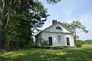
Rowe is a town in Franklin County, Massachusetts, United States. The population was 424 at the 2020 census.

<span class="mw-page-title-main">Shutesbury, Massachusetts</span> Town in Massachusetts, United States

Shutesbury is a town in Franklin County, Massachusetts, United States. The population was 1,717 at the 2020 census. It is part of the Springfield, Massachusetts Metropolitan Statistical Area.

<span class="mw-page-title-main">Warwick, Massachusetts</span> Town in Massachusetts, United States

Warwick is a town in Franklin County, Massachusetts, United States. The population was 780 at the 2020 census. It is part of the Springfield, Massachusetts Metropolitan Statistical Area.

<span class="mw-page-title-main">Pelham, Massachusetts</span> Town in Massachusetts, United States

Pelham is a town in Hampshire County, Massachusetts, United States. The population was 1,280 at the 2020 census. Its ZIP Code is shared with Amherst.

<span class="mw-page-title-main">Hardwick, Massachusetts</span> Town in Massachusetts, United States

Hardwick is a town in Worcester County, Massachusetts, United States, about 20 miles (32 km) northwest of the city of Worcester. It had a population of 2,667 at the 2020 census. It includes the villages of Hardwick, Gilbertville, Wheelwright and Old Furnace.

<span class="mw-page-title-main">Oakham, Massachusetts</span> Town in Massachusetts, United States

Oakham is a town in Worcester County, Massachusetts, United States. The population was 1,851 at the 2020 census.

<span class="mw-page-title-main">Petersham, Massachusetts</span> Town in Massachusetts, United States

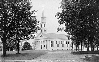
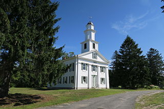
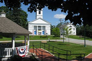
Petersham is a town in Worcester County, Massachusetts, United States. The population was 1,194 at the 2020 census. Petersham is home to a considerable amount of conservation land, including the Quabbin Reservation, Harvard Forest, the Swift River Reservation, and Federated Women's Club State Forest.

<span class="mw-page-title-main">Royalston, Massachusetts</span> Town in Massachusetts, United States

Royalston is a town in Worcester County, Massachusetts, United States. The population was 1,250 at the 2020 census.

<span class="mw-page-title-main">Orange, Massachusetts</span> Town in Massachusetts, United States

Orange is a town in Franklin County, Massachusetts, United States. The population was 7,569 at the 2020 census. It is part of the Springfield, Massachusetts Metropolitan Statistical Area.

<span class="mw-page-title-main">Belchertown, Massachusetts</span> Town in Massachusetts, United States

Belchertown is a town in Hampshire County, Massachusetts, United States. It is part of the Springfield, Massachusetts Metropolitan Statistical Area. The population was 15,350 at the 2020 census. The town includes the census-designated place of Belchertown. Belchertown was formerly the home of the Belchertown State School. The land on which the school sat is, as of 2016, being redeveloped for mixed uses including residential, commercial and recreational. This includes the 385-acre (156 ha) Lampson Brook Farm, used for community and sustainable agriculture, outdoor recreation, and wildlife preservation.

<span class="mw-page-title-main">Ware, Massachusetts</span> Town in Massachusetts, United States

Ware is a town in Hampshire County, Massachusetts, United States. The population was 10,066 as of 2020. It is part of the Springfield, Massachusetts Metropolitan Statistical Area.

<span class="mw-page-title-main">Athol, Massachusetts</span> Town in Massachusetts, United States

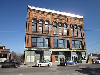
Athol is a town in Worcester County, Massachusetts, United States. The population was 11,945 at the 2020 census.

<span class="mw-page-title-main">Barre, Massachusetts</span> Town in Massachusetts, United States

Barre is a town in Worcester County, Massachusetts, United States. The population was 5,530 at the 2020 census.

<span class="mw-page-title-main">Enfield, Massachusetts</span> Town in Massachusetts, United States

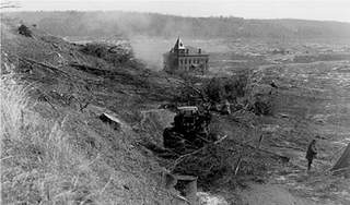
Enfield was a town in Hampshire County, Massachusetts, United States. The town was lost as a result of the creation of the Quabbin Reservoir.

<span class="mw-page-title-main">Quabbin Reservoir</span> Massachusetts reservoir which serves the Boston area

The Quabbin Reservoir is the largest inland body of water in Massachusetts, and was built between 1930 and 1939. Along with the Wachusett Reservoir, it is the primary water supply for Boston, 65 miles (105 km) to the east, and 40 other cities and towns in Greater Boston. The Quabbin also supplies water to three towns west of the reservoir and acts as backup supply for three others. By 1989, it supplied water for 2.5 million people, about 40% of the state's population at the time. It has an aggregate capacity of 412 billion US gallons (1,560 GL) and an area of 38.6 square miles (99.9 km2).

<span class="mw-page-title-main">Prescott, Massachusetts</span> Town in Massachusetts, United States

Prescott was a town in Hampshire County, Massachusetts, United States. It was incorporated in 1822 from portions of Pelham and New Salem, and was partially built on Equivalent Lands. It was named in honor of Colonel William Prescott, who commanded the American forces at the Battle of Bunker Hill. It was disincorporated on April 28, 1938, as part of the creation of the Quabbin Reservoir. It was the least populous of the four unincorporated towns, with barely 300 residents by 1900. Upon dissolution, portions of the town were annexed to the adjacent towns of New Salem and Petersham. The majority of the former town is still above water, and is known as the Prescott Peninsula. The public is not allowed on the peninsula except for an annual tour given by the Swift River Valley Historical Society, or for hikes conducted by the Society. None of the land is in Hampshire County any longer; the New Salem portion is in Franklin County; and the Petersham portion is in Worcester County.

<span class="mw-page-title-main">Greenwich, Massachusetts</span> Town in Massachusetts, United States

Greenwich was a town in Hampshire County, Massachusetts, United States. The town was lost as a result of the formation of the Quabbin Reservoir in order to supply Boston's growing water needs.

<span class="mw-page-title-main">Quabbin–Swift River Valley</span> Region of Massachusetts, United States

The Quabbin Valley is a region of Massachusetts in the United States. The region consists of the Quabbin Reservoir and accompanying river systems in Franklin, Hampden, Hampshire, and Worcester counties. The area is sometimes known as the Swift River Valley region, a reference to the Swift River, which was dammed to form the reservoir.

References

  1. 1 2 U.S. Geological Survey Geographic Names Information System: New Salem, Massachusetts
  2. "Census - Geography Profile: New Salem town, Franklin County, Massachusetts". United States Census Bureau . Retrieved November 14, 2021.
  3. "MWRA Historic Observatory at Quabbin Decommissioned". Massachusetts Water Resources Authority. Retrieved October 17, 2012.
  4. "Geographic Identifiers: 2010 Demographic Profile Data (G001): New Salem town, Franklin County, Massachusetts". United States Census Bureau . Retrieved August 28, 2012.
  5. "Climate in New Salem, Massachusetts" . Retrieved August 8, 2022.
  6. "Total Population (P1), 2010 Census Summary File 1". American FactFinder, All County Subdivisions within Massachusetts. United States Census Bureau. 2010.
  7. "Massachusetts by Place and County Subdivision - GCT-T1. Population Estimates". United States Census Bureau. Retrieved July 12, 2011.
  8. "1990 Census of Population, General Population Characteristics: Massachusetts" (PDF). US Census Bureau. December 1990. Table 76: General Characteristics of Persons, Households, and Families: 1990. 1990 CP-1-23. Retrieved July 12, 2011.
  9. "1980 Census of the Population, Number of Inhabitants: Massachusetts" (PDF). US Census Bureau. December 1981. Table 4. Populations of County Subdivisions: 1960 to 1980. PC80-1-A23. Retrieved July 12, 2011.
  10. "1950 Census of Population" (PDF). Bureau of the Census. 1952. Section 6, Pages 21-10 and 21-11, Massachusetts Table 6. Population of Counties by Minor Civil Divisions: 1930 to 1950. Retrieved July 12, 2011.
  11. "1920 Census of Population" (PDF). Bureau of the Census. Number of Inhabitants, by Counties and Minor Civil Divisions. Pages 21-5 through 21-7. Massachusetts Table 2. Population of Counties by Minor Civil Divisions: 1920, 1910, and 1920. Retrieved July 12, 2011.
  12. "1890 Census of the Population" (PDF). Department of the Interior, Census Office. Pages 179 through 182. Massachusetts Table 5. Population of States and Territories by Minor Civil Divisions: 1880 and 1890. Retrieved July 12, 2011.
  13. "1870 Census of the Population" (PDF). Department of the Interior, Census Office. 1872. Pages 217 through 220. Table IX. Population of Minor Civil Divisions, &c. Massachusetts. Retrieved July 12, 2011.
  14. "1860 Census" (PDF). Department of the Interior, Census Office. 1864. Pages 220 through 226. State of Massachusetts Table No. 3. Populations of Cities, Towns, &c. Retrieved July 12, 2011.
  15. "1850 Census" (PDF). Department of the Interior, Census Office. 1854. Pages 338 through 393. Populations of Cities, Towns, &c. Retrieved July 12, 2011.
  16. "City and Town Population Totals: 2020-2022". United States Census Bureau . Retrieved September 5, 2023.
  17. "U.S. Census website". United States Census Bureau . Retrieved January 31, 2008.
  18. Who Was Who in America, Historical Volume, 1607-1896. Marquis Who's Who. 1967.
  19. 'Biographical Review of Dane County, Wisconsin Containing Biographical Sketches of Pioneers and Leading Citizens,' Biographical Review Publishing Company, Chicago, Illinois, Biographical Sketch of Hiram Giles, pg. 417-418
  20. Bullard, Eugene (sesquicentennial chairman): New Salem Sesqui-Centennial and History of the Town 1903, Athol, Massachusetts (1904) pg 21, 49.