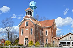
New Washington, Indiana

Last updated

New Washington, Indiana
CDP
New Washington Normal School.jpg
Former school
Clark County Indiana Incorporated and Unincorporated areas New Washington Highlighted 1853820.svg
Location of New Washington in Clark County, Indiana.
Coordinates: 38°33′56″N85°32′46″W / 38.56556°N 85.54611°W / 38.56556; -85.54611
Country United States
State Indiana
County Clark
Township Washington
Area
[1]
  Total5.22 sq mi (13.52 km2)
  Land5.21 sq mi (13.49 km2)
  Water0.01 sq mi (0.04 km2)
Elevation
[2]
715 ft (218 m)
Population
 (2020)
  Total595
  Density114.25/sq mi (44.11/km2)
Time zone UTC-5 (Eastern (EST))
  Summer (DST) UTC-4 (EDT)
ZIP code
47162
Area code 812
FIPS code 18-53820 [3]
GNIS feature ID2393150 [2]

New Washington is a census-designated place (CDP) in Clark County, Indiana, United States. As of the 2010 census, the population was 566. [4]

Contents

Photo from Small Town Indiana photo survey. New Washington, Indiana.jpg
Photo from Small Town Indiana photo survey.

History

New Washington was established in 1815. [5] A post office was established at New Washington in 1819. [6]

New Washington was the closest community to the now-defunct Marble Hill Nuclear Power Plant. [7]

Geography

New Washington is located in northeastern Clark County. Indiana State Road 62 runs through the center of the community, leading north then east 19 miles (31 km) to Madison and southwest 24 miles (39 km) to Jeffersonville across the Ohio River from Louisville, Kentucky.

According to the United States Census Bureau, the CDP has a total area of 5.2 square miles (13.5 km2), of which 0.02 square miles (0.04 km2), or 0.29%, is water. [4]

Demographics

Historical population
CensusPop.Note
2020 595
U.S. Decennial Census [8]

As of the census [3] of 2000, there were 547 people, 228 households, and 163 families residing in the CDP. The population density was 104.8 inhabitants per square mile (40.5/km2). There were 253 housing units at an average density of 48.5 per square mile (18.7/km2). The racial makeup of the CDP was 99.63% White and 0.37% African American.

There were 229 households, out of which 27.6% had children under the age of 18 living with them, 58.8% were married couples living together, 10.5% had a female householder with no husband present, and 28.5% were non-families. 25.0% of all households were made up of individuals, and 12.7% had someone living alone who was 65 years of age or older. The average household size was 2.38 and the average family size was 2.85.

In the CDP the population was spread out, with 20.7% under the age of 18, 10.1% from 18 to 24, 26.7% from 25 to 44, 26.7% from 45 to 64, and 15.9% who were 65 years of age or older. The median age was 40 years. For every 100 females, there were 85.4 males. For every 100 females age 18 and over, there were 79.3 males.

The median income for a household in the CDP was $37,368, and the median income for a family was $42,292. Males had a median income of $31,359 versus $14,750 for females. The per capita income for the CDP was $19,343. About 2.3% of families and 8.2% of the population were below the poverty line, including 18.3% of those under age 18 and 16.9% of those age 65 or over.

Education

New Washington has a public library, elementary school, [9] middle/high school, [10] and a branch of the Charlestown-Clark County Public Library. [11]

Related Research Articles

<span class="mw-page-title-main">Charlestown, Indiana</span> City in Indiana, United States

Charlestown is a city located within Charlestown Township, in Clark County, Indiana, United States. The population was 7,775 at the 2020 census.

<span class="mw-page-title-main">Henryville, Indiana</span> Census-designated place in Indiana, United States

Henryville is a census-designated place (CDP) in Monroe Township, Clark County, in the U.S. state of Indiana. The population was 1,905 at the 2010 census.

<span class="mw-page-title-main">Memphis, Indiana</span> CDP in Indiana, United States

Memphis is a census-designated place (CDP) in Clark County, Indiana, United States. The population was 695 at the 2010 census.

<span class="mw-page-title-main">Oak Park, Indiana</span> CDP in Indiana, United States

Oak Park is a census-designated place (CDP) in Clark County, Indiana, United States. The population was 5,379 at the 2000 census.

<span class="mw-page-title-main">Sellersburg, Indiana</span> Town in Indiana, United States

Sellersburg is a town located within Silver Creek Township, Clark County, Indiana, United States. It had a population of 9,310 at time of the 2020 census. Sellersburg is located along Interstate 65, about 15 minutes north of Louisville.

<span class="mw-page-title-main">New Paris, Indiana</span> Census-designated place in Indiana, United States

New Paris is a census-designated place (CDP) in Elkhart County, Indiana, United States. The population was 1,494 at the 2010 census.

<span class="mw-page-title-main">Simonton Lake, Indiana</span> Census-designated place in Indiana, United States

Simonton Lake is a census-designated place (CDP) in Elkhart County, Indiana, United States. The population was 4,678 at the 2010 census.

<span class="mw-page-title-main">Galena, Indiana</span> Census-designated place in Indiana, United States

Galena is a census-designated place (CDP) in Floyd County, Indiana, United States. The population was 1,818 at the 2010 census. The CDP includes the town of Galena as well as the nearby town of Floyds Knobs and their immediate surroundings.

<span class="mw-page-title-main">Collegeville, Indiana</span> Census-designated place in Indiana, United States

Collegeville is a census-designated place (CDP) in Jasper County, Indiana, United States. The population was 330 at the 2010 census. Collegeville is home to the now-unaccredited Saint Joseph's College, the source of the town's name.

<span class="mw-page-title-main">Zia Pueblo, New Mexico</span> CDP in New Mexico, United States

Zia Pueblo is a census-designated place (CDP) in Sandoval County, New Mexico, United States. The population was 646 at the 2000 census, with 310 males and 336 females. The pueblo after which the CDP is named is included within the CDP; it is listed on the National Register of Historic Places.

<span class="mw-page-title-main">Salem, North Carolina</span> Census-designated place in North Carolina, United States

Salem is a census-designated place (CDP) in Burke County, North Carolina, United States. The population was 2,218 at the 2010 census. It is part of the Hickory–Lenoir–Morganton Metropolitan Statistical Area.

<span class="mw-page-title-main">Ross, Ohio</span> Census-designated place in Ohio, United States

Ross is a census-designated place (CDP) in Ross Township, Butler County, Ohio, United States. The population was 3,478 at the 2020 census. Ross sits along U.S. Route 27 between Cincinnati, Ohio and Oxford, Ohio. Ross is part of the Cincinnati metropolitan area.

<span class="mw-page-title-main">Park Layne, Ohio</span> Census-designated place in Ohio, United States

Park Layne is a census-designated place (CDP) in Bethel Township, Clark County, Ohio, United States. The population of the CDP was 4,248 at the 2020 census. It is part of the Springfield, Ohio Metropolitan Statistical Area. Park Layne became a CDP in the 1980 United States Census.

<span class="mw-page-title-main">Amboy, Washington</span> Census-designated place in Washington, United States

Amboy is a census-designated place (CDP) in Clark County, Washington, United States. The population was 1,838 at the 2020 census, up from 1,608 at the 2010 census. It is located 33 miles northeast of Vancouver which is part of the Portland-Vancouver metropolitan area.

<span class="mw-page-title-main">Cherry Grove, Washington</span> Census-designated place in Washington, United States

Cherry Grove is a census-designated place (CDP) in Clark County, Washington, United States. The population was 546 at the 2010 census, down from 663 at the 2000 census.

<span class="mw-page-title-main">Hockinson, Washington</span> Census-designated place in Washington, United States

Hockinson is a census-designated place (CDP) in Clark County, Washington, United States. The population was 4,771 at the 2010 census.

<span class="mw-page-title-main">Lewisville, Washington</span> Census-designated place in Washington, United States

Lewisville is a census-designated place (CDP) in Clark County, Washington, United States. The population was 1,722 at the 2010 census.

<span class="mw-page-title-main">Walnut Grove, Washington</span> Census-designated place in Washington, United States

Walnut Grove is a census-designated place (CDP) in Clark County, Washington, United States. The population was 9,790 at the 2010 census, up from 7,164 at the 2000 census.

<span class="mw-page-title-main">Ames Lake, Washington</span> Census-designated place in Washington, United States

Ames Lake is an unincorporated community and census-designated place (CDP) in King County, Washington, United States. The population was 1,486 at the 2010 census.

<span class="mw-page-title-main">Charlestown (CDP), New Hampshire</span> Census-designated place in New Hampshire, United States

Charlestown is a census-designated place (CDP) and the main village in the town of Charlestown, Sullivan County, New Hampshire, United States. The population of the CDP was 1,078 at the 2020 census, out of 4,806 in the entire town.

References

  1. "2020 U.S. Gazetteer Files". United States Census Bureau. Retrieved March 16, 2022.
  2. 1 2 U.S. Geological Survey Geographic Names Information System: New Washington, Indiana
  3. 1 2 "U.S. Census website". United States Census Bureau . Retrieved January 31, 2008.
  4. 1 2 "Geographic Identifiers: 2010 Demographic Profile Data (G001): New Washington CDP, Indiana". U.S. Census Bureau, American Factfinder. Archived from the original on February 12, 2020. Retrieved August 4, 2014.
  5. Baker, Ronald L. (October 1995). From Needmore to Prosperity: Hoosier Place Names in Folklore and History . Indiana University Press. p.  242. ISBN   978-0-253-32866-3. This village was laid out in 1815...
  6. "Clark County". Jim Forte Postal History. Retrieved August 30, 2014.
  7. United States Nuclear Regulatory Commission Information Digest 2010-2011. Government Printing Office. August 12, 2011. p. 117. ISBN   978-0-16-088436-8.
  8. "Census of Population and Housing". Census.gov. Retrieved June 4, 2016.
  9. "New Washington Elementary School – Mustangs". nwes.gcs.k12.in.us. Retrieved November 8, 2019.
  10. "New Washington Middle High School". New Washington Middle High School. Retrieved November 8, 2019.
  11. "Locations". Charlestown-Clark County Public Library. Archived from the original on March 4, 2018. Retrieved March 4, 2018.