New York and Putnam Railroad

Last updated

New York and Putnam Railroad
Putnam Division map2.png
Overview
Reporting mark NYP
Locale Manhattan, The Bronx, and Westchester and Putnam Counties, New York
Dates of operation1881 (1881)1958 (1958)
Successor New York Central Railroad
Technical
Track gauge 4 ft 8+12 in (1,435 mm) standard gauge
Route map

Contents

BSicon CONTg.svg
Harlem Line
to Wassaic
BSicon HST.svg
Brewster
BSicon exSTR+l.svg
BSicon exSTRq.svg
BSicon eABZgr+r.svg
53.82 mi
86.61 km
Putnam Junction
BSicon exHST.svg
BSicon STR.svg
51.84 mi
83.43 km
Tilly Foster
BSicon exHST.svg
BSicon LSTR.svg
49.58 mi
79.79 km
Carmel
BSicon exHST.svg
BSicon LSTR.svg
47.20 mi
75.96 km
Crafts
BSicon exHST.svg
BSicon LSTR.svg
45.13 mi
72.63 km
Mahopac
BSicon exKRWgl.svg
BSicon exKRW+r.svg
BSicon LSTR.svg
BSicon exSTR.svg
BSicon exHST.svg
BSicon STR.svg
Shenorock
BSicon exSTR.svg
BSicon exHST.svg
BSicon STR.svg
Lincolndale
BSicon exSTR.svg
BSicon exKRWl.svg
BSicon eKRWg+r.svg
BSicon exKHSTa.svg
BSicon exSTR.svg
BSicon STR.svg
Mahopac Mines
BSicon exHST.svg
BSicon exSTR.svg
BSicon LSTR.svg
Mahopac Falls
BSicon exSTR.svg
BSicon exHST.svg
44.38 mi
71.42 km
Lake Mahopac
BSicon exKRWl.svg
BSicon exKRWg+r.svg
BSicon exHST.svg
42.25 mi
67.99 km
Baldwin Place
BSicon exHST.svg
39.96 mi
64.31 km
~Granite Springs
BSicon exHST.svg
37.94 mi
61.06 km
Amawalk
BSicon exKHSTa.svg
BSicon exSTR.svg
Mohansic State Hospital
BSicon exKRWl.svg
BSicon exKRWg+r.svg
BSicon exHST.svg
36.76 mi
59.16 km
Yorktown Heights
BSicon exHST.svg
35.04 mi
56.39 km
Croton Heights
BSicon exHST.svg
33.57 mi
54.03 km
Croton Lake
BSicon exHST.svg
32.52 mi
52.34 km
Kitchawan
BSicon exHST.svg
30.44 mi
48.99 km
Millwood
BSicon exHST.svg
27.04 mi
43.52 km
Briarcliff Manor
BSicon POINTERf@gq.svg
BSicon exKRW+l.svg
BSicon exKRWlr.svg
BSicon exKRW+r.svg
pre-1931 alignment
BSicon exSTR.svg
BSicon exHST.svg
23.92 mi
38.5 km
Graham
BSicon exHST.svg
BSicon exSTR.svg
Whitsons
BSicon exKRWgl.svg
BSicon POINTERg@rfq.svg
BSicon exKRW+r.svg
BSicon exSTR.svg
pre-1881 alignment
BSicon exHST.svg
BSicon exlHST.svg
BSicon exhSTRa@g.svg
BSicon exSTR.svg
Pocantico Hills
BSicon exHST.svg
BSicon exhSTR.svg
BSicon exSTR.svg
Tower Hill
BSicon exHST.svg
BSicon exhSTR.svg
BSicon exSTR.svg
Tarrytown Heights
BSicon exKRWl.svg
BSicon exhKRWl.svg
BSicon exKRW+lr.svg
BSicon exhKRW+r.svg
BSicon exKRWr.svg
BSicon exHST.svg
BSicon exlHST.svg
BSicon exhSTRe@f.svg
20.41 mi
32.85 km
Eastview
BSicon exKRWg+l.svg
BSicon exKRWr.svg
BSicon exHST.svg
Beaver Hill
BSicon exHST.svg
18.14 mi
29.19 km
Elmsford
BSicon exHST.svg
16.60 mi
26.72 km
Worthington
BSicon exHST.svg
Woodlands
BSicon exHST.svg
14.72 mi
23.69 km
Ardsley
BSicon exHST.svg
13.86 mi
22.31 km
Chauncey
BSicon exHST.svg
13.02 mi
20.95 km
Mount Hope
BSicon exHST.svg
12.01 mi
19.33 km
Nepera Park
BSicon exHST.svg
11.92 mi
19.18 km
Gray Oaks
BSicon exHST.svg
10.50 mi
16.9 km
Nepperham
BSicon exHST.svg
9.44 mi
15.19 km
Bryn Mawr Park
BSicon exHST.svg
8.09 mi
13.02 km
Dunwoodie
BSicon exKHSTa.svg
BSicon exSTR.svg
Getty Square
BSicon exHST.svg
BSicon exSTR.svg
Park Hill
BSicon exHST.svg
BSicon exSTR.svg
Lowerre
BSicon exSTR.svg
BSicon exHST.svg
6.52 mi
10.49 km
Lincoln
BSicon exHST.svg
BSicon exSTR.svg
Caryl
BSicon exHST.svg
BSicon exSTR.svg
Mosholu
BSicon exKRWl.svg
BSicon exKRWg+r.svg
BSicon exHST.svg
4.82 mi
7.76 km
Van Cortlandt
BSicon exHST.svg
Kings Bridge
BSicon CONTgq.svg
BSicon xABZg+r.svg
Hudson Line
to Poughkeepsie
BSicon eHST.svg
Fordham Heights
BSicon HST.svg
University Heights
BSicon HST.svg
Morris Heights
BSicon HST.svg
Highbridge
BSicon eHST.svg
0.0 mi
0 km
Sedgwick Avenue
BSicon exSTR+l.svg
BSicon eABZgr.svg
BSicon LSTR.svg
BSicon exKBHFe.svg
BSicon STR.svg
BSicon STR.svg
155th Street
BSicon STRl.svg
BSicon STRq.svg
BSicon ABZgr+r.svg
Port Morris Junction
BSicon CONTf.svg
Harlem Line
to Grand Central

The New York and Putnam Railroad, nicknamed the Old Put, was a railroad line that operated between the Bronx and Brewster in New York State. It was in close proximity to the Hudson River Railroad and New York and Harlem Railroad. All three came under ownership of the New York Central system in 1894. The railroad was abandoned starting in 1958, and most of the former roadbed has been converted to rail trail use.

History

Early years, charter

The planned New York, Boston & Montreal Railway route between the New York & Putnam Railroad and the Harlem Extension Railroad NYB&M.jpg
The planned New York, Boston & Montreal Railway route between the New York & Putnam Railroad and the Harlem Extension Railroad

The New York & Boston Railroad (NY&B) was chartered on May 21, 1869 [1] to build a line from Highbridge on the Harlem River in New York northeast to Brewster. At Brewster connections were to be provided to the New York & Harlem Railroad for travel north to Albany, and to the Boston, Hartford & Erie Railroad to Boston. The railway would see several name changes and reorganizations before construction commenced. [2]

The New York, Boston & Northern Railway (NYB&N) was formed on November 18, 1872, as a consolidation of the NY&B with two companies to the north — the Putnam & Dutchess Railroad (P&D) and Dutchess & Columbia Railroad (D&C). The P&D was a plan for a line to split from the New York and Boston at Carmel to a point midway along the D&C. The D&C opened in 1871, running from the Hudson River to the Connecticut border. The Clove Branch Railroad was to serve as a short connection between the two parts of the planned line.

The New York, Boston & Montreal Railway was organized on January 21, 1873, as a renaming of the NYB&N. It continued north to Chatham on what is now the defunct section of the Harlem Line and then used the Harlem Extension Railroad into Vermont. The Panic of 1873 caused the cancellation of the leases and mergers on December 1 of that year. Construction on the P&D and D&C stopped; D&C later became part of the Central New England Railway, the Harlem Extension became a part of the Rutland Railroad, and the Clove Branch Railroad was abandoned in 1898.

The New York, Westchester & Putnam Railway was formed on July 3, 1877, as a reorganization, and was leased to the New York City & Northern Railroad (NYC&N), formed on March 1, 1878. Between East View and Pocantico Hills, the NYC&N built a segment leading to a perilous 80-foot-high trestle over a marsh-filled valley. [3] Because of the dangers of crossing the bridge, which often required that trains slow down to a crawl, the line was rerouted west around that valley in 1881. The bridge was torn down in 1883, and the valley became the Tarrytown Reservoir. [4] The line finally opened under the original plan, ending at Brewster, in April 1881. That year, the New York & New England Railroad opened to the north, using some of the grade built for the P&D and D&C. The West Side & Yonkers Railway was leased to the NYC&N on May 1, 1880, extending the line south across the Harlem River to the northern terminal of the Ninth Avenue Elevated at 155th Street. It was merged into the NYC&N by 1887. In the 1910s, the Interborough Rapid Transit Company (IRT) of the New York City Subway purchased the bridge across the Harlem River to move its elevated lines north into the Bronx, cutting the NYP back to Sedgwick Avenue. The Yonkers Rapid Transit Railway was opened in 1888 as a branch from the NYP at Van Cortlandt northwest to Yonkers. It was merged into NYP by 1887.

Reorganization and decline

Gold Bond of the New York and Putnam Rail Road Company, issued 15. January 1894 New York and Putnam RR 1894.jpg
Gold Bond of the New York and Putnam Rail Road Company, issued 15. January 1894
New York Central's Putnam Division, Getty Square branch Southbound (Eastbound) electric schedules from Employee Timetable No. 55 effective 1942-06-07 showing service operated before abandonment on June 30, 1943. Tracks were torn-out in December, 1944, after a legal battle. NYCRR Put 19420607.png
New York Central's Putnam Division, Getty Square branch Southbound (Eastbound) electric schedules from Employee Timetable No. 55 effective 1942-06-07 showing service operated before abandonment on June 30, 1943. Tracks were torn-out in December, 1944, after a legal battle.

The company went into receivership by 1887 and was reorganized as the New York & Northern Railway. By 1894 it was reorganized as the New York & Putnam Rail Road Company (NY&P) by J. P. Morgan, who in turn leased the railroad to the New York Central & Hudson River Railroad (NYC&HR). [1] The line eventually became the Putnam Division of the New York Central Railroad (NYC) by 1913. The line lacked a direct connection to NYC's flagship station, Grand Central Terminal (GCT), which hurt ridership throughout its existence. Workweek commuters and weekend tourists were forced to transfer at Highbridge to reach GCT. [5] The Sedgwick Avenue-Van Cortlandt section and the Yonkers Branch were electrified in 1926.

Several short branches were eliminated after the 1920s. The Mohansic Branch near Yorktown Heights, originally built to serve a mental institution that was canceled by Albany, went first. In 1929, John D. Rockefeller Jr. had the tracks removed from his Pocantico Hills property, eliminating four stations while creating one. The nearby village of East View was obliterated to build the new line. The Getty Square Branch was abandoned on June 30, 1943. [6] Despite a legal battle by Yonkers residents which reached the United States Supreme Court to save it, the line was scrapped in December 1944. [7] [8]

The first diesel locomotive passenger train in the U.S. ran on the Putnam on March 18, 1929.[ citation needed ]

Besides the regular Sedgwick Avenue–Brewster service, service also operated from Golden's Bridge on the Harlem Division via a connecting branch to Lake Mahopac, and then over the Putnam Division to Brewster, where it returned to the Harlem Division. Trains taking this route were said to go "around the horn".

End of service

NYC saw the Putnam Division as a dispensable stepchild. The line lacked a second track, electrification, commuter parking and direct service to GCT, all of which the parallel Harlem and Hudson Divisions had, resulting in declining patronage. In 1956, the New York Central asked for permission to discontinue service on the line. On May 14, 1957, the Public Service Commission allowed a 15 percent increase in fares, but required that service be run on the Putnam Division on a limited basis. On March 12, 1958, the Public Service Commission authorized the NYC to end passenger service on the Putnam on June 1, 1958. At the time, the line had less than 500 daily riders, and discontinuing the line was expected to save $400,000 annually. The last trains ran on May 29, 1958, as there was no weekend service on the line. [1] [9] Service "around the horn" via the Harlem Division's Lake Mahopac Branch continued until April 2, 1959. Until 1962, when NYC's West Shore Railroad was upgraded, the Putnam served oversize freight trains, due to the lack of tunnels on the line. Tracks between East View and Lake Mahopac were removed in 1962.

NYC merged with long-time rival Pennsylvania Railroad to form Penn Central (PC) in 1968. Freight service on the northern part of the Putnam ended in March 1970. The southern end of the line remained in service until the closing of the A&P warehouse in Elmsford, in 1975. The decrease in traffic from Stauffer Chemical cut back the line to Chauncey by 1977. Conrail took over the bankrupt PC in April 1976, but had no plans for increasing business. The last customer was the Stella D'Oro bakery in the Bronx, which stopped using the railroad in 1989, after which Conrail wanted to sell the right-of-way to the city and Westchester to reduce its tax bill. [10]

In 1991, the Regional Plan Association proposed extending the line and connecting it with the IRT Broadway–Seventh Avenue Line ( 1 train) of the New York City Subway. [10]

Legacy

Marble Hill stub in Manhattan Old Put working stub jeh.jpg
Marble Hill stub in Manhattan

The Metro-North Railroad uses the remaining stub near Marble Hill station to store maintenance-of-way and contractors' trains, and for material delivery in the vicinity of West 225th Street. [10] The roadbed north of the former Van Cortlandt station has been converted into the Putnam Greenway, South County Trailway, North County Trailway, and Putnam County Trailway rail trails.

Remaining stations

A replica of the former Bryn Mawr Park station at the former Palmer Road grade crossing is in use as a grocery. The station in Briarcliff Manor was purchased by the village in 1959 and converted into the Briarcliff Manor Public Library. [11] The station in Millwood remained until 2012, but it was torn down in May 2012 due to structural instability. The station in Elmsford serves as a restaurant. The Yorktown Heights station had its exterior restored and is the centerpiece of the town park. The station in Lake Mahopac has been an American Legion Hall since 1965. [12] The freight house in Baldwin Place and the station in Tilly Foster remain but are on private property. Skeletal remnants of the Van Cortlandt station remain in Van Cortlandt Park.

Getty Square Branch

The Getty Square Branch still shows evidence of its existence, with vestiges of the railroad and stations, and neighborhoods exhibiting characteristics of transit-oriented development. [13] Getty Square station, originally a head house and train shed, was replaced by an office building, which still stands and is ornamented on its exterior and in its lobby with images of locomotives. The 3.4 miles (5.5 km)-long right-of-way is part of the trail system in Van Cortlandt Park, including the bridge that carried the branch over the Henry Hudson Parkway. Old railroad ties can be found along the right-of-way. The right-of-way within New York City ends at a parking garage for an apartment building in Yonkers. To the north of the apartment building, another parking lot was built. The bridge over the adjacent street was walled-in where the ROW used to pass underneath. [10]

Abutments of the former branch can be found at School Street across from Herriott Street, McLean Avenue near South Broadway, and the former Lowerre Station on Lawrence Street at Western Avenue. The former Caryl Station on Caryl Avenue between Saratoga and Van Cortlandt Park Avenues, with the tunnel into Van Cortlandt Park walled-off by cinder blocks, is now the Caryl parking lot and playground. [14] A lot of the intrusions on the branch were from the expansion of outside storage from adjacent industries, which broke up the right-of-way in many places, especially in Yonkers. [10]

Private homes that once served the branch include the termini houses of the Park Hill station's adjacent funicular, on Undercliff at Park Hill Terrace, [15] and on Alta Avenue [16] north of Overcliff, and the home of the railroad's president, also on Alta Avenue. North from the Yonkers-New York City boundary, the path of the route generally follows the path of the Saw Mill River Parkway until it reaches East Irvington.

Station listing

New York and Putnam Railroad
Map of the New York and Putnam with sections labelled by the first companies to operate the line

Main Line

NOTE: Stations along pre-1918 Manhattan terminus and pre-1931 Tarrytown Heights alignment are shaded in darker gray.

LocalityMilepostStationLat/longNotes/Connections
Manhattan 155th Street Terminal Original terminal from 1881 to 1918.
Putnam Bridge across the Harlem River; taken over by IRT Ninth Avenue Line in 1918
The Bronx 0.0 Sedgwick Avenue 40°49′53.12″N73°55′56.15″W / 40.8314222°N 73.9322639°W / 40.8314222; -73.9322639 NYC Transit: Connected to former IRT Ninth Avenue Line station and West Side/High Line
Highbridge 40°50′17.5″N73°55′53″W / 40.838194°N 73.93139°W / 40.838194; -73.93139 Now the Highbridge Maintenance Facility.
Morris Heights 40°51′14.4″N73°55′11.64″W / 40.854000°N 73.9199000°W / 40.854000; -73.9199000
University Heights 40°51′41.04″N73°54′52.92″W / 40.8614000°N 73.9147000°W / 40.8614000; -73.9147000
Fordham Heights Merged with University Heights Station in early 20th Century
Hudson & Putnam Lines split
Kings Bridge Somewhere between 225th Street and 231st Street; Not to be confused with
the Spuyten Duyvil and Port Morris Railroad station of the same name.
4.82 Van Cortlandt 40°53′20.7″N73°53′36.9″W / 40.889083°N 73.893583°W / 40.889083; -73.893583 Inside Van Cortlandt Park
Junction with electrified Getty Square Branch
Westchester 6.52 Lincoln at McLean Avenue
8.09 Dunwoodie At Yonkers Avenue east of Dunwoodie Golf Course
9.44 Bryn Mawr Park 40°56.6905′0″N73°51.4825′0″W / 40.94484°N 73.85804°W / 40.94484; -73.85804 Replaced in 1995 by Palmer/Bryn Mawr Market
10.50 Nepperham
11.92 Gray Oaks
12.01 Nepera Park
13.02 Mount Hope
13.86 Chauncey
14.72 Ardsley Off NY 9A between Saw Mill River Parkway and New York State Thruway.
Woodlands Small wooden platform and opened shelter with canopy along Woodlands Lake. [17]
16.60 Worthington Current day bike path does not pass the station location. Station looked similar to Crafts station.
18.14 Elmsford 41°03′16″N73°49′14″W / 41.05444°N 73.82056°W / 41.05444; -73.82056 Currently a restaurant
Beaver Hill Wooden shelter designed as a flag stop for former Fairview Golf Club
Original alignment from short-lived 80-foot high Eastview Trestle segment began here (1880-1881).
20.41 Eastview 41°04′50″N73°49′45″W / 41.08056°N 73.82917°W / 41.08056; -73.82917 Original pre-1929 relocation line began here.
Tarrytown Heights Built March 1882; First station along Tarrytown Heights alignment
west of East View station and original NY&P alignment
Tower Hill Built November 26, 1881; Second station on former alignment west
of Tarrytown Reservoir existed here until 1931
Pocantico Hills Built November 26, 1881; Third station along former alignment near
Rockefeller Estate and Tarrytown Reservoir existed here until 1931
Original alignment from short-lived 80-foot high Eastview Trestle segment ended here (1880-1881).
Whitsons Fourth station along previous alignment. Replaced in 1931 by Graham station on new alignment
23.92 Graham Created by 1931 relocation, Original pre-1929 alignment ended just north of here.
Open shelter that was proposed for major expansion which never occurred.
27.04 Briarcliff Manor 41°08′48″N73°49′28″W / 41.14667°N 73.82444°W / 41.14667; -73.82444 Currently the Briarcliff Manor Public Library.
30.44 Millwood 41°11′24.3126″N73°47′48.9942″W / 41.190086833°N 73.796942833°W / 41.190086833; -73.796942833
32.52 Kitchawan
33.57 Croton Lake
35.04 Croton Heights
36.76 Yorktown Heights 41°16′17.5″N73°46′47″W / 41.271528°N 73.77972°W / 41.271528; -73.77972 At Railroad Park on the National Register of Historic Places. Originally contained
a coach yard and an engine service facility.
Connection to Mohansic Branch
37.94 Amawalk 41°17′11″N73°46′13″W / 41.2864°N 73.7703°W / 41.2864; -73.7703 Amawalk's station agent was eliminated on February 8, 1935. [18]
39.96 Granite Springs
Putnam 42.25 Baldwin Place 41°20′43″N73°45′16″W / 41.34535°N 73.75453°W / 41.34535; -73.75453
Connection to Mahopac Mines Branch
44.38 Lake Mahopac 41°22′17″N73°44′04″W / 41.371440°N 73.734583°W / 41.371440; -73.734583 Currently an American Legion Hall
Connection to Lake Mahopac Branch and NYC's Harlem Division
45.13 Mahopac 41°22′43″N73°43′27″W / 41.3787°N 73.7241°W / 41.3787; -73.7241
47.20 Crafts
49.58 Carmel Southern terminus of unbuilt Putnam & Dutchess Railroad.
51.84 Tilly Foster Originally built for the Tilly Foster Mine, which closed in 1897. Station continued to operate.
53.82Putnam JunctionNot a station, connection with Harlem Division and Brewster Yard; included bridge to
Beacon Line (a.k.a. CNE Highland Division) until 1907. [19]
Brewster 41°23′40.92″N73°37′11.28″W / 41.3947000°N 73.6198000°W / 41.3947000; -73.6198000
Line continues along NYC's Harlem Division

Branches

Getty Square Branch

LocalityMilepostStationLat/longNotes/Connections
The Bronx 0.0 Van Cortlandt 40°53′28.185″N73°53′31.649″W / 40.89116250°N 73.89212472°W / 40.89116250; -73.89212472 Beginning of Getty Square Branch
Putnam & Getty Square Branches split
Mosholu Abandoned 1926
Yonkers Caryl North of Caryl Avenue Bridge, which still exists today.
Lowerre South of Lawrence Street between Western and Van Cortlandt Park Avenues.
3.0 Park Hill Connected to former Park Hill Incline funicular railroad
3.2 Getty Square
Line abandoned in 1943

Mohansic Branch

LocalityMilepostStationLat/longNotes/Connections
Westchester 0.0 Yorktown Heights 41°16′17.5″N73°46′47″W / 41.271528°N 73.77972°W / 41.271528; -73.77972
Putnam Line & Mohansic Branch split
Mohansic State Hospital N.A.Never built. Branch was abandoned when the hospital project was cancelled before station was constructed.
Line abandoned in 1917

Mahopac Mines Branch

LocalityMilepostStationLat/longNotes/Connections
Putnam 0.0 Baldwin Place 41°20′43″N73°45′16″W / 41.34535°N 73.75453°W / 41.34535; -73.75453
Putnam & Mahopac Mines Lines split
Mahopac Falls 41°22′15″N73°45′44″W / 41.3708°N 73.7621°W / 41.3708; -73.7621
4.0 Mahopac Mines 41°23′51″N73°45′30″W / 41.3974°N 73.7584°W / 41.3974; -73.7584 Seldom used by customers. Also had a turn table and water tower.
Line abandoned in 1931

Lake Mahopac Branch

LocalityMilepostStationLat/longNotes/Connections
Putnam 0.0Lake Mahopac 41°22′17″N73°44′04″W / 41.371440°N 73.734583°W / 41.371440; -73.734583 Putnam Division connection
0.40XCUnmanned junction where the Lake Mahopac Branch crossed the Putnam Division.
Westchester 3.00Shenorock 41°20′10″N73°44′12″W / 41.3361°N 73.7367°W / 41.3361; -73.7367 Flag stop, 9/10 mile west of Lincolndale.
3.91Lincolndale 41°19′25″N73°43′08″W / 41.323715°N 73.719014°W / 41.323715; -73.719014 Stone station building.
7.22Golden's Bridge 41°17′40″N73°40′39″W / 41.294491°N 73.677568°W / 41.294491; -73.677568 Harlem Division connection
Line abandoned in 1959


See also

Related Research Articles

<span class="mw-page-title-main">Putnam County, New York</span> County in New York, United States

Putnam County is a county located in the U.S. state of New York. As of the 2020 census, the population was 97,668. The county seat is Carmel. Putnam County was formed in 1812 from Dutchess County and is named for Israel Putnam, a hero in the French and Indian War and a general in the American Revolutionary War.

<span class="mw-page-title-main">Yonkers, New York</span> City in New York, United States

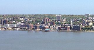
Yonkers is a city in Westchester County, New York, United States. The city, a core suburb of the New York Metropolitan Area had a population of 211,569 as of the 2020 United States Census. It is classified as an inner suburb of New York City, located directly to the north of the Bronx and approximately 2.4 miles (4 km) north of Marble Hill, the northernmost point in Manhattan.

<span class="mw-page-title-main">Yorktown, New York</span> Town in New York, United States

Yorktown is a town on the northern border of Westchester County, New York, United States. A suburb of the New York City metropolitan area, it is approximately 38 miles (61 km) north of midtown Manhattan. The population was 36,569 at the 2020 U.S. Census.

<span class="mw-page-title-main">Brewster station</span> Metro-North Railroad station in New York

Brewster station is a commuter rail stop on the Metro-North Railroad's Harlem Line, located in Brewster, New York.

<span class="mw-page-title-main">Bee-Line Bus System</span> Bus system in Westchester County, New York, U.S.

The Westchester County Bee-Line System, branded on the buses in lowercase as the bee-line system, is a bus system serving Westchester County, New York. The system is owned by the county's Department of Public Works and Transportation.

<span class="mw-page-title-main">Millwood, New York</span> Hamlet & CDP in New York, United States

Millwood is a hamlet and census-designated place located in the town of New Castle, New York, United States in Westchester County. It was originally settled as Sarlesville. The area now known as Millwood appears on 19th century maps as Merritt's Corners and Rockdale Mills. As of the 2000 census, the community had a population of 1,210.

<span class="mw-page-title-main">Harlem Line</span> Metro-North Railroad line in New York

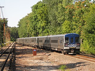
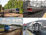
The Harlem Line is an 82-mile (132 km) commuter rail line owned and operated by the Metro-North Railroad in the U.S. state of New York. It runs north from New York City to Wassaic, in eastern Dutchess County. The lower 53 miles (85 km) from Grand Central Terminal to Southeast, in Putnam County, is electrified with a third rail and has at least two tracks. The section north of Southeast is a non-electrified single-track line served by diesel locomotives. Before the renaming of the line in 1983, it eventually became the Harlem Division of the New York Central Railroad. The diesel trains usually run as a shuttle on the northern end of the line, except for rush-hour express trains in the peak direction.

<span class="mw-page-title-main">Getty Square</span> Public square in Yonkers, New York

Getty Square is the name for downtown Yonkers, New York, centered on the public square. Getty Square is the civic center, central business district, and transit hub of the City of Yonkers. A dense and growing residential area, it is located in southern Westchester County, New York. The square is named after prominent 19th-century merchant Robert Getty.

<span class="mw-page-title-main">Croton Aqueduct</span> Pipeline that carried water to New York City from its reservoirs in 19th century

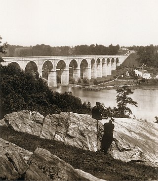
The Croton Aqueduct or Old Croton Aqueduct was a large and complex water distribution system constructed for New York City between 1837 and 1842. The great aqueducts, which were among the first in the United States, carried water by gravity 41 miles (66 km) from the Croton River in Westchester County to reservoirs in Manhattan. It was built because local water resources had become polluted and inadequate for the growing population of the city. Although the aqueduct was largely superseded by the New Croton Aqueduct, which was built in 1890, the Old Croton Aqueduct remained in service until 1955.

<span class="mw-page-title-main">Hudson Line (Metro-North)</span> Metro-North Railroad line in New York

The Hudson Line is a commuter rail line owned and operated by the Metro-North Railroad in the U.S. state of New York. It runs north from New York City along the east shore of the Hudson River, terminating at Poughkeepsie. The line was originally the Hudson River Railroad, and eventually became the Hudson Division of the New York Central Railroad. It runs along what was the far southern leg of the Central's famed "Water Level Route" to Chicago.

<span class="mw-page-title-main">Van Cortlandt Park</span> Large public park in the Bronx, New York

Van Cortlandt Park is a 1,146-acre (464 ha) park located in the borough of the Bronx in New York City. Owned by the New York City Department of Parks and Recreation, it is managed with assistance from the Van Cortlandt Park Alliance. The park, the city's third-largest, was named for the Van Cortlandt family, which was prominent in the area during the Dutch and English colonial periods.

<span class="mw-page-title-main">New York State Route 100</span> State highway in Westchester New York, US

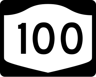
New York State Route 100 (NY 100) is a major north–south state highway in Westchester County, New York, in the United States. It begins parallel to Interstate 87 (I-87) at a junction with the Cross County Parkway in the city of Yonkers and runs through most of the length of the county up to U.S. Route 202 (US 202) in the town of Somers. NY 100 was designated as part of the 1930 renumbering of state highways in New York. Prior to becoming a state road, various sections of NY 100 were part of several important early roads in the county.

<span class="mw-page-title-main">North County Trailway</span> Rail trail in Westchester County, New York

The North County Trailway is a 22.1-mile (35.6 km) long paved rail trail stretching from Eastview to Baldwin Place in Westchester County, New York. It is also part of the statewide Empire State Trail.

<span class="mw-page-title-main">Third Avenue Railway</span> Streetcar system in southern New York (1852–1952)

The Third Avenue Railway System (TARS), founded 1852, was a streetcar system serving the New York City boroughs of Manhattan and the Bronx along with lower Westchester County. For a brief period of time, TARS also operated the Steinway Lines in Long Island City.

<span class="mw-page-title-main">South County Trailway</span>

The South County Trailway is a 14.1-mile (22.7 km) long rail trail stretching from the Putnam Trail in Van Cortlandt Park in the Bronx to the North County Trailway in East View, New York. Westchester County Parks constructed the trailway in segments beginning in 1990 and completed it on October 31, 2017.

<span class="mw-page-title-main">New York, Westchester and Boston Railway</span> Former U.S. railway company

The New York, Westchester and Boston Railway Company, was an electric commuter railroad in the Bronx and Westchester County, New York from 1912 to 1937. It ran from the southernmost part of the South Bronx, near the Harlem River, to Mount Vernon with branches north to White Plains and east to Port Chester. From 1906, construction and operation was under the control of the New York, New Haven & Hartford Railroad (NH) until its bankruptcy in 1935.

<span class="mw-page-title-main">Yorktown Heights station</span> Historic site

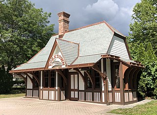
Yorktown Heights station is a former railroad station on the Putnam Line in Yorktown Heights, New York, United States. It is a wooden building located on Commerce Street at the intersection of Underhill Avenue in Railroad Park.

<span class="mw-page-title-main">Woodlands Lake</span> Reservoir in Greenburgh, New York

Woodlands Lake is a reservoir in Greenburgh, New York. It is an impoundment of the Saw Mill River. It is located in VE Macy Park.

<span class="mw-page-title-main">Briarcliff Manor Public Library</span> Public library serving Briarcliff Manor, New York

The Briarcliff Manor Public Library is the public library serving the village of Briarcliff Manor, New York, and is located on the edge of the Walter W. Law Memorial Park. The library is a founding member of the Westchester Library System. It is staffed by a director and eleven employees, including reference and youth librarians, and is governed by a ten-member board, with a liaison to the village board of trustees. The library offers computer classes, book discussion groups, young adult programs, a children's room and a local history collection. The library building also houses the Briarcliff Manor-Scarborough Historical Society, the Briarcliff Manor Recreation Department, and the William J. Vescio Community Center.

<span class="mw-page-title-main">Tibbetts Brook</span> Stream in downstate New York

Tibbetts Brook, originally Tippett's Brook or Tibbitt's Brook, is a stream in the southern portion of mainland New York, flowing north to south from the city of Yonkers in Westchester County into the borough of the Bronx within New York City. Originally emptying into Spuyten Duyvil Creek as part of the Harlem River system, the stream is now partially subterranean, ending above ground at the south end of Van Cortlandt Lake within Van Cortlandt Park. There it proceeds into city sewers, draining into either the northern end of the Harlem River or the Wards Island Water Pollution Control Plant. The brook provides significant watershed to both Van Cortlandt Park at its south end and Tibbetts Brook Park at its north end. There have been modern proposals to daylight the southern portion of the brook back onto the surface.

References

  1. 1 2 3 Knowles, Clayton (March 13, 1958). "P.S.C. Lets Central Close Putnam Line And Increase Fares; CENTRAL TO DROP ITS PUTNAM LINE" (PDF). The New York Times. ISSN   0362-4331 . Retrieved June 22, 2017.
  2. nycshsblogger (October 15, 2008). "The Putnam Division". NYCSHS. Retrieved February 19, 2024.
  3. "Images related to Tarry Town Trestle". NYPL Digital Gallery .
  4. The Eastview Trestle (Archive Sleuth)
  5. "Putnam County Trailway". Putnam County, New York. Retrieved February 19, 2024.
  6. "Getty Square Line Ends; 12 Riders on Last Trip". The New York Times. July 1, 1943. p. 21. Retrieved July 4, 2011.
  7. "High Court Lets Road Drop Getty Sq. Line". The New York Times. November 14, 1944. Retrieved July 4, 2011.
  8. "Putnam Line Being Razed". The New York Times. December 9, 1944. p. 30. Retrieved July 4, 2011.
  9. Folsom, Merrill (May 30, 1958). "The Wheels of 'Old Put' Click Out a Sad Accompaniment to Riders' 'Auld Lang Syne'". New York Times . p. 23. Retrieved July 4, 2011.
  10. 1 2 3 4 5 An Assessment of the Transit Service Potential of Inactive Railroad Rights-of-way and Yards Final Report. New York City Department of City Planning. October 1991. pp. 12–16.
  11. Library History (Briarcliff Manor Public Library)
  12. The American Legion Mahopac Post 1080
  13. Klein, Daniel A. (2004). "The Phantom Spur Retracing the Vanished Getty Square Branch of the Putnam Railroad". National Railway Bulletin. 69 (2): 28–37.
  14. Caryl Lot (Yonkers Parking Authority)
  15. Park Hill Lower Station; 1999 Bill Kessler Photograph (Existing stations in Westchester County, New York)
  16. Park Hill Upper Station; 2000 Walter Hahn Photograph (Existing stations in Westchester County, New York)
  17. Great Hunger Memorial Park at V.E. Macy (Scenes From the Trail; Includes the history of Woodlands NY&P station)
  18. "Amawalk Railroad Station Closed". The Putnam County Courier. Carmel, New York. February 8, 1935. p. 1. Retrieved October 16, 2018.
  19. Grogan, Louis V. (1989). The Coming of the New York and Harlem Railroad. Self-Published. p. 154. ISBN   0-962120-65-0.

Further reading