
Inverclyde is one of 32 council areas used for local government in Scotland. Together with the East Renfrewshire and Renfrewshire council areas, Inverclyde forms part of the historic county of Renfrewshire, which currently exists as a registration county and lieutenancy area – located in the west central Lowlands. It borders the North Ayrshire and Renfrewshire council areas, and is otherwise surrounded by the Firth of Clyde.
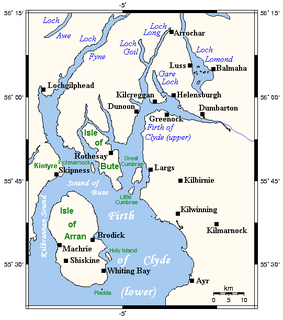
The Firth of Clyde is the mouth of the River Clyde. It is located on the west coast of Scotland and constitutes the deepest coastal waters in the British Isles. The firth is sheltered from the Atlantic Ocean by the Kintyre peninsula, which encloses the outer firth in Argyll and Ayrshire. The Kilbrannan Sound is a large arm of the Firth of Clyde, separating the Kintyre Peninsula from the Isle of Arran. Within the Firth of Clyde is another major island – the Isle of Bute. Given its strategic location at the entrance to the middle and upper Clyde, Bute played a vital naval military role during World War II.

Skelmorlie is a village in North Ayrshire in the south-west of Scotland. Although it is the northernmost settlement in the council area of North Ayrshire, it is contiguous with Wemyss Bay, which is in Inverclyde. The dividing line is the Kelly Burn, which flows into the Firth of Clyde just south of the Rothesay ferry terminal. Despite their proximity, the two villages have historically been divided, Skelmorlie in Ayrshire and Wemyss Bay in Renfrewshire.

Port Glasgow is the second-largest town in the Inverclyde council area of Scotland. The population according to the 1991 census for Port Glasgow was 19,426 persons and in the 2001 census was 16,617 persons. The most recent census in 2011 states that the population has declined to 15,414. It is located immediately to the east of Greenock and was previously a burgh in the county of Renfrewshire.
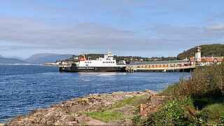
Wemyss Bay is a village on the coast of the Firth of Clyde in Inverclyde in the west central Lowlands of Scotland. It is in the traditional county of Renfrewshire. It is adjacent to Skelmorlie, North Ayrshire. The villages have always been in separate counties, divided by the Kelly Burn.

A dovecote or dovecot, doocot (Scots) or columbarium is a structure intended to house pigeons or doves. Dovecotes may be free-standing structures in a variety of shapes, or built into the end of a house or barn. They generally contain pigeonholes for the birds to nest. Pigeons and doves were an important food source historically in the Middle East and Europe and were kept for their eggs and dung.

Fairlie is a village in North Ayrshire, Scotland.
Kilmacolm is a village and civil parish in the Inverclyde council area, and the historic county of Renfrewshire in the west central Lowlands of Scotland. It lies on the northern slope of the Gryffe Valley, 7+1⁄2 miles southeast of Greenock and around 15 miles (24 km) west of the city of Glasgow. The village has a population of around 4,000 and is part of a wider civil parish which covers a large rural hinterland of 15,000 hectares containing within it the smaller settlement of Quarrier's Village, originally established as a 19th-century residential orphans' home.

Orchardton Tower is a ruined tower house in Kirkcudbrightshire, Dumfries and Galloway, Scotland. It is located four miles south of Dalbeattie, and one mile south of Palnackie, in Buittle parish. It is remarkable as the only cylindrical tower house in Scotland. Orchardton Tower is in the care of Historic Environment Scotland as a Scheduled Ancient Monument.
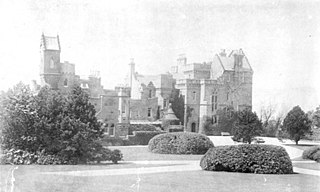
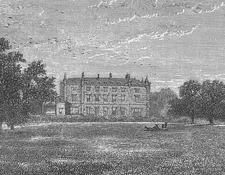
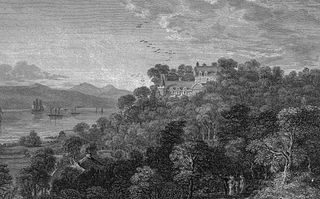
Castle Wemyss was a large mansion in Wemyss Bay, Scotland. It stood on the southern shore of the Firth of Clyde at Wemyss Point, where the firth turns southwards.
Barmkin, also spelled barmekin or barnekin, is a Scots word which refers to a form of medieval and later defensive enclosure, typically found around smaller castles, tower houses, pele towers, and bastle houses in Scotland, and the north of England. It has been suggested that etymologically the word may be a corruption of the word barbican or berm. The barmkin would have contained ancillary buildings, and could be used to protect cattle during raids.
The Tower of Hallbar, also known as Hallbar Tower and Braidwood Castle, is a 16th-century tower house, located to the west of the River Clyde in South Lanarkshire, Scotland. The tower is situated above the Braidwood Burn, 3.5 km (2.2 mi) south-west of Carluke, and 1.5 km (0.93 mi) east of Crossford. It has been restored and is let out as holiday accommodation.

Newark Tower is a large, ruined tower house standing in the grounds of Bowhill House, in the valley of the Yarrow Water three miles west of Selkirk in the Scottish Borders. In addition to the keep, sections of a gatehouse and wall survive. It has been designated a scheduled monument by Historic Environment Scotland.
Eglinton Country Park is located on the grounds of the old Eglinton Castle estate in Kilwinning, North Ayrshire, Scotland. Eglinton Park is situated in the parish of Kilwinning, part of the former district of Cunninghame, and covers an area of 400 ha. The central iconic feature of the country park is the ruined Eglinton Castle, once home to the Eglinton family and later the Montgomeries, Earls of Eglinton and chiefs of the Clan Montgomery. Eglinton Country Park is managed and maintained by North Ayrshire Council and its Ranger Service.

Montgreenan is an estate in North Ayrshire, Parish of Kilwinning, Scotland. The Lugton Water runs through the policies and farmland of Montgreenan. Nearby are the hamlets of Torranyard and Auchentiber.
Caldwell is a mansion and old estate with the remains of a castle nearby. These lands lie close to the Lugton Water and the villages of Uplawmoor in East Renfrewshire and Lugton in East Ayrshire.

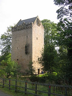
Mearns Castle is a 15th-century tower house in Newton Mearns, East Renfrewshire, south of Glasgow, Scotland. It is a Category A listed building. The castle has been restored and is now part of the Maxwell Mearns Castle Church. It also gives its name to nearby Mearns Castle High School.

Little Cumbrae Castle sits on Allimturrail or Castle Island, a small tidal island, situated off the east coast of Little Cumbrae, in the Firth of Clyde. It is designated as a scheduled monument.
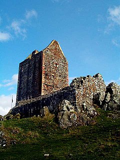
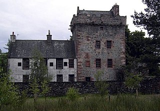
Skelmorlie Castle stands on the eastern shore of the Firth of Clyde, Scotland, at the north-western corner of the county of Ayrshire. The structure dates from 1502, and was formerly the seat and stronghold of the Montgomery Clan. The modern village of Skelmorlie lies to the north of the castle.
Hills Tower is a sixteenth-century square tower house, with an adjoining eighteenth-century wing, near Dumfries in Scotland. Originally built around 1527 for Edward Maxwell, who had purchased the estate from James Douglas of Drumlanrig, it was improved in the later sixteenth century by his grandson, also Edward Maxwell. In 1721, another Edward Maxwell had a two-storey Georgian wing added to the tower's east side, using stone taken from older buildings nearby, and incorporating armorial panels celebrating members of the Maxwell family.


