Newark Valley (village), New York

Last updated

Newark Valley
Village
NY 38 in Newark Valley.jpg
NY 38 northbound in Newark Valley.
USA New York location map.svg
Red pog.svg
Newark Valley
Location within the state of New York
Coordinates: 42°13′23″N76°11′8″W / 42.22306°N 76.18556°W / 42.22306; -76.18556
Country United States
State New York
County Tioga
Settled1791 (1791)
IncorporatedSeptember 1894 (1894-09)
Named for Newark, New Jersey
Area
[1]
  Total0.99 sq mi (2.56 km2)
  Land0.99 sq mi (2.56 km2)
  Water0.00 sq mi (0.00 km2)
Elevation
968 ft (295 m)
Population
 (2020)
  Total928
  Density939.27/sq mi (362.73/km2)
Time zone UTC-5 (Eastern (EST))
  Summer (DST) UTC-4 (EDT)
ZIP code
13811
Area code 607
FIPS code 36-49902
GNIS feature ID0958490
Website villagenv.com

Newark Valley is a village in Tioga County, New York, United States. The population was 997 at the 2010 census. It is part of the Binghamton Metropolitan Statistical Area. The village is named after the city of Newark, New Jersey.

Contents

Newark Valley is in the western part of the Town of Newark Valley and is northwest of Binghamton.

History

The former Lehigh Valley Railroad station in Newark Valley Newark Valley Station.jpg
The former Lehigh Valley Railroad station in Newark Valley

The site of the village was first settled around 1792. Although many of the early settlers came from New England, the town name was accepted on a suggestion from someone from New Jersey.

The village of Newark Valley was incorporated in 1894.

The Hope Cemetery and Mausoleum, Knapp House, Newark Valley Municipal Building and Tappan-Spaulding Memorial Library, Nowland House, Gilbert E. Purple House, Silk Street Bridge, and Sutton-Chapman-Howland House are listed on the National Register of Historic Places. [2]

Geography

According to the United States Census Bureau, the village has a total area of 1.0 square mile (2.5 km2), all land.

The village is in the valley of the East Branch of Owego Creek, on Route 38 (Main Street), north of its junction with NY-38B and south of its junction with County Road 37.

Demographics

Historical population
CensusPop.Note
1890 875
1900 818−6.5%
1910 92513.1%
1920 821−11.2%
1930 795−3.2%
1940 94919.4%
1950 1,0278.2%
1960 1,23420.2%
1970 1,2864.2%
1980 1,190−7.5%
1990 1,082−9.1%
2000 1,071−1.0%
2010 997−6.9%
2020 928−6.9%
U.S. Decennial Census [3]

As of the census [4] of 2000, there were 1,071 people, 390 households, and 276 families residing in the village. The population density was 1,096.6 inhabitants per square mile (423.4/km2). There were 446 housing units at an average density of 456.6 per square mile (176.3/km2). The racial makeup of the village was 97.67% White, 0.75% Black or African American, 0.19% Native American, 0.75% from other races, and 0.65% from two or more races. Hispanic or Latino of any race were 1.31% of the population.

There were 390 households, out of which 37.7% had children under the age of 18 living with them, 54.4% were married couples living together, 11.5% had a female householder with no husband present, and 29.2% were non-families. 26.4% of all households were made up of individuals, and 13.3% had someone living alone who was 65 years of age or older. The average household size was 2.58 and the average family size was 3.09.

In the village, the population was spread out, with 29.7% under the age of 18, 7.6% from 18 to 24, 28.6% from 25 to 44, 19.9% from 45 to 64, and 14.3% who were 65 years of age or older. The median age was 36 years. For every 100 females, there were 98.0 males. For every 100 females age 18 and over, there were 93.1 males.

The median income for a household in the village was $37,935, and the median income for a family was $42,604. Males had a median income of $30,750 versus $19,250 for females. The per capita income for the village was $16,919. About 7.7% of families and 12.3% of the population were below the poverty line, including 12.2% of those under age 18 and 9.0% of those age 65 or over.

Education

Newark Valley is home to Newark Valley Central School District, a public school system composed of an elementary, middle, and senior-high schools. On average, the district graduates 100 seniors a year.

Related Research Articles

<span class="mw-page-title-main">Kirkwood, New York</span> Town in New York, United States

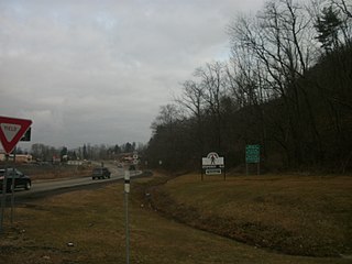
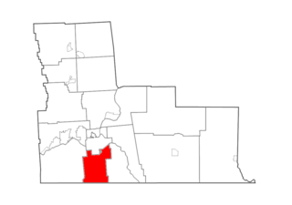
Kirkwood is a town in Broome County, New York, United States. The population was 5,495 at the 2020 census. The town is named after James P. Kirkwood, who was an engineer responsible for constructing the local railroad.

<span class="mw-page-title-main">Maine, New York</span> Town in New York, United States

Maine is a town in Broome County, New York, United States. The population was 5,377 at the 2010 census.

<span class="mw-page-title-main">Warren, New York</span> Town in Herkimer County, New York, US

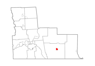
Warren is a town in Herkimer County, New York, United States. The population was 1,143 at the 2010 census. The town is named after General Joseph Warren, who was killed at the Battle of Bunker Hill. Warren is in the south part of Herkimer County. US 20 passes across the town.

West Sparta is a town in Livingston County, New York, United States. The population was 1,255 at the 2010 census. The name is derived from the neighboring town of Sparta.

Berkshire is a town in Tioga County, New York, United States. As of the 2020 census, it had a population of 1,485. The town is named after Berkshire County, Massachusetts.

<span class="mw-page-title-main">Caroline, New York</span> Town in New York, United States

Caroline is a town in Tompkins County, New York, United States. The population was 3,282 at the 2010 census.

<span class="mw-page-title-main">Alexandria, Ohio</span> Village in Ohio, United States

Alexandria is a village in Licking County, Ohio, United States. The population was 483 at the 2020 census.

<span class="mw-page-title-main">Deposit (village), New York</span> Village in New York, United States

Deposit is a village in Broome and Delaware counties in the U.S. state of New York. The population was 1,663 at the 2010 census.

<span class="mw-page-title-main">Binghamton (town), New York</span> Town in New York, United States

Binghamton is a town in Broome County, New York, United States. The population was 4,623 at the 2020 census. The town is named after an early developer, William Bingham.

<span class="mw-page-title-main">Windsor (village), New York</span> Village in New York, United States

Windsor is a village in Broome County, New York, United States. The population was 916 at the 2010 census. It is part of the Binghamton Metropolitan Statistical Area.

Afton is a village in Chenango County, New York, United States. The population was 822 at the 2010 census. The village is named after the poem "Sweet Afton" by Scottish poet Robert Burns, referring to the River Afton in Ayrshire, Scotland.

<span class="mw-page-title-main">Oxford (village), New York</span> Village in New York, United States

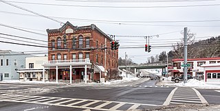
Oxford is a village in Chenango County, New York, United States. The population was 1,450 at the 2010 census. The village is named after Oxford, Massachusetts, the hometown of the landowner.

<span class="mw-page-title-main">Marathon (village), New York</span> Village in New York, United States

Marathon is a village within the town of Marathon in Cortland County, New York, United States. The population of the village was 919 at the 2010 census, out of 1,967 in the entire town.

<span class="mw-page-title-main">Pawling (village), New York</span> Village in New York, United States

Pawling is a village in Dutchess County, New York, United States. The population was 2,347 at the 2010 census. It is part of the Poughkeepsie–Newburgh–Middletown, NY Metropolitan Statistical Area as well as the larger New York–Newark–Bridgeport, NY-NJ-CT-PA Combined Statistical Area. The John Kane House, a registered historic place, is situated in the village. The village was portrayed as the fictional town of Denning, New York, in the TV series Elementary.

<span class="mw-page-title-main">Addison (village), New York</span> Village in New York, United States

Addison is a village in Steuben County, New York, United States. The population was 1,763 at the 2010 census. The village and the surrounding town are named after the author Joseph Addison.

Cohocton is a town in Steuben County, New York, United States. The population was 2,268 at the 2020 census. The town contains a village, also called Cohocton and is located in the northwestern part of the county.

Newark Valley is a town in Tioga County, New York, United States. The population was 3,660 at the 2020 census. The town is named after the city of Newark, New Jersey.

<span class="mw-page-title-main">Nichols (village), New York</span> Village in New York, United States

Nichols is a village located in the Town of Nichols in Tioga County, New York, United States. The population was 512 at the 2010 census. It is part of the Binghamton Metropolitan Statistical Area. The name is taken from that of a local benefactor, Colonel Nichols.

Nichols is a town in Tioga County, New York, United States. The town contains a village also called Nichols. The town is on the south border of both the county and the state. The town is halfway between Binghamton and Elmira. The population was 2,357 at the 2020 census. The town is named after Colonel Nichols, an early landowner.

Patch Grove is a village in Grant County, Wisconsin, United States. The population was 198 at the 2010 census. The village is located within the Town of Patch Grove.

References

  1. "ArcGIS REST Services Directory". United States Census Bureau. Retrieved September 20, 2022.
  2. "National Register Information System". National Register of Historic Places . National Park Service. March 13, 2009.
  3. "Census of Population and Housing". Census.gov. Retrieved June 4, 2015.
  4. "U.S. Census website". United States Census Bureau . Retrieved January 31, 2008.