
Chepstow is a town and community in Monmouthshire, Wales, adjoining the border with Gloucestershire, England. It is located on the tidal River Wye, about 2 miles (3.2 km) above its confluence with the River Severn, and adjoining the western end of the Severn Bridge. It is the easternmost settlement in Wales, situated 16 miles (26 km) east of Newport, 28 miles (45 km) east-northeast of Cardiff, 18 miles (29 km) northwest of Bristol and 110 miles (180 km) west of London.
Monmouthshire is a principal area in Wales. The name derives from the historic county of Monmouthshire of which it covers the eastern three-fifths. The largest town is Abergavenny. Other towns and large villages are Caldicot, Chepstow, Monmouth, Magor and Usk. It borders Torfaen, Newport and Blaenau Gwent to the west; Herefordshire and Gloucestershire to the east; and Powys to the north.
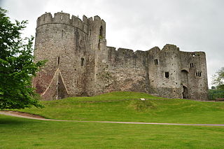
Chepstow Castle at Chepstow, Monmouthshire, Wales is the oldest surviving post-Roman stone fortification in Britain. Located above cliffs on the River Wye, construction began in 1067 under the instruction of the Norman Lord William FitzOsbern. Originally known as Striguil, it was the southernmost of a chain of castles built in the Welsh Marches, and with its attached lordship took the name of the adjoining market town in about the 14th century.

Itton, is a small village in Monmouthshire, south-east Wales, in the community of Devauden about 3 miles (4.8 km) north-west of Chepstow. The village covers about a 2-mile (3.2 km) radius, with about 70 properties across a rural area. The parish also includes the hamlet of Howick.

Caldicot was an ancient hundred of Monmouthshire, Wales.

St. Brides Netherwent is a parish and largely deserted village in Monmouthshire, south east Wales. It is centred 2 miles north of Magor, and 3 miles west of Caerwent. The A48 Newport to Chepstow road passes close by to the north.

Llanvair Discoed is a small village in Monmouthshire, south-east Wales, 6 miles west of Chepstow and 10 miles east of Newport.
Striguil or Strigoil is the name which was used from the 11th century until the late 14th century for the port and Norman castle of Chepstow, on the Welsh side of the River Wye which forms the boundary with England. The name was also applied to the Marcher lordship which controlled the area in the period between the Norman conquest and the formation of Monmouthshire under the Laws in Wales Acts 1535–1542.
Wentwood, in Monmouthshire, South Wales, is a forested area of hills, rising to 1,014 feet (309 m) above sea level. It is located to the northeast of, and partly within the boundaries of, the city of Newport.
Devauden is a village and community in Monmouthshire, southeast Wales. It is located between Chepstow and Monmouth near the top of the Trellech ridge on the B4293 road. The community covers an area of 3,790 hectares (14.6 sq mi). The community includes the villages of Itton and Wolvesnewton, Llanfihangel-tor-y-mynydd and Newchurch.

Wolvesnewton is a small village in Monmouthshire, Wales.

Tredunnock is a small village in Monmouthshire, south east Wales, in the United Kingdom. Tredunnock is located four miles (6.4 km) northeast of Caerleon and four miles south of Usk.
Llangwm is a small rural village and community in Monmouthshire, south east Wales. It is located 3 miles (4.8 km) east of Usk, on the B4235 Chepstow to Usk road. The main village is at Llangwm Uchaf, with a smaller and more dispersed settlement about 1 mile (1.6 km) to the north-east at Llangwm Isaf .The other settlement in the community is Llansoy.

Pen-y-clawdd is a village in Monmouthshire, south east Wales, situated between Raglan and Monmouth. The village is the site of a medieval fortification and there is a historic church with an ancient cross in the churchyard which is a scheduled monument.

Trelleck Grange is a small hamlet in a rural area of Monmouthshire, south east Wales, United Kingdom, about seven miles south of Monmouth.

Gwernesney is a village in Monmouthshire in southeast Wales.
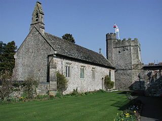
St Pierre is a former parish and hamlet in Monmouthshire, south east Wales, 3 miles (4.8 km) south west of Chepstow and adjacent to the Severn Estuary. It is now the site of a large golf and country club, the Marriott St Pierre Hotel & Country Club, which was previously a large manor house and deer park belonging to the Lewis family.

Llanfihangel Tor-y-Mynydd is a small rural village in the community of Devauden, Monmouthshire, Wales. It is located within the Vale of Usk, about 9 miles south west of Monmouth and 6 miles east of the town of Usk, between the villages of Devauden and Llansoy.

Pen-y-cae-mawr is small hamlet above the Wentwood Forest in Monmouthshire, Wales. It lies about 2 miles (3.2 km) east of Llantrisant.

The Monmouthshire Way is a circular long-distance footpath of 116 miles that explores the historic county of Monmouth. Short sections of the route trespass into the neighbouring counties of Gloucester, Hereford and Brecon. It was designed by the South Wales Long Distance Walkers Association and is currently not waymarked.
