A bonspiel is a curling tournament, consisting of several games, often held on a weekend. Until the 20th century most bonspiels were held outdoors, on a frozen freshwater loch. Today almost all bonspiels are held indoors on specially prepared artificial ice.

New Farm Loch is a suburb to the North-East of Kilmarnock, East Ayrshire, Scotland and was created in the late 1960s by a number of builders to accommodate the growing population of Kilmarnock.
Riccarton is a village and parish in East Ayrshire, Scotland. It lies across the River Irvine from Kilmarnock, this river forming the boundary between Riccarton and Kilmarnock parishes, and also between the historical districts of Kyle and Cunningham. The name is a corruption of 'Richard's town', traditionally said to refer to Richard Wallace, the uncle of Sir William Wallace. The parish also contains the village of Hurlford.
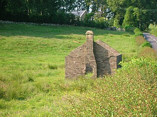
A curling house was used to store curling stones, brushes and other equipment used to maintain a curling pond and play the game of curling in Scotland and elsewhere.

Lambroughton Loch or Wheatrig Loch was situated in a low-lying area between the farms and dwellings of Hillhead, Lambroughton, Wheatrig, Titwood and Lochridge mainly in the Parish of Dreghorn, North Ayrshire. The loch was mainly fed by the Lochridge Burn, the Garrier Burn and surface runoff, such as from the old rig and furrows indicated by Roy's maps of the mid-18th century. The loch outflow was via the Lochridge Burn that runs into the Garrier Burn, passes the site of the old Lochend habitation and into the Bracken Burn near Little Alton. The rivulet or watercourse is known as the Garrier Burn beyond this point.
Lochlea or Lochlie was situated in a low-lying area between the farms and dwellings of Lochlea and Lochside in the Parish of Tarbolton, South Ayrshire, Scotland. The loch was natural, sitting in a hollow created by glaciation. The loch waters ultimately drained via Fail Loch, the Mill Burn, and the Water of Fail. It is well-documented due to the presence of a crannog that was excavated and documented circa 1878, and its association with the poet Robert Burns, who lived here for several years whilst his father was the tenant. Lochlea lies 2+1⁄2 miles northeast of Tarbolton, and just over three miles northwest of Mauchline.
Buiston Loch, also known as Buston, Biston and Mid Buiston, was situated in the mid-Ayrshire clayland at an altitude of 90 m OD. The loch was natural, sitting in a hollow created by glaciation. The loch waters drained via the Garrier Burn that joins the Bracken and Lochridge Burns before joining the River Irvine.

Loch Brown, also known in Scots as Loch Broun, Broon or Broom, was situated in a kettle hole in the mid-Ayrshire clayland near Crosshands. It is nowadays (2011) visible as a surface depression in pastureland, partially flooded, situated in a low-lying area close to farms and dwellings of Skeoch, Dalsangan, Ladebrae, Lochhill, and Crosshands, mainly in the Parish of Mauchline and partly in Craigie, East Ayrshire, Scotland. Duveloch is an old name for the loch and this may derive from the Gaelic Dubh, meaning black or dark loch.
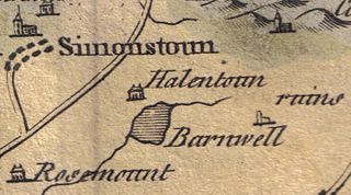
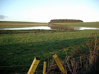
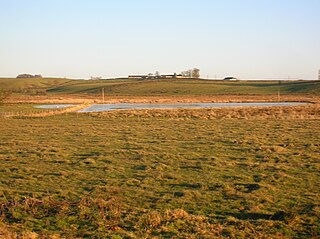
Helenton Loch was situated in a low lying area between the farms and dwellings of Helentongate, Mains, and Burnbank in the Parish of Symington, South Ayrshire, Scotland. The loch was natural, sitting in a hollow, a kettle hole, created by glaciation. The loch waters ultimately drained via the Pow Burn. Helenton Hill is a prominent landmark to the west of the old loch site. The nearby lands of Rosemount were in 1549 known as 'Goldring' and were the property of the Schaws of Sornbeg.

Fail Loch or Faile Loch was situated in a low-lying area near the old monastery of Fail in the Parish of Tarbolton, South Ayrshire, Scotland. The old Lochlea Loch lies nearby and its waters still feed into Fail Loch via the Mill Burn.
Hessilhead Loch or Hazelhead Loch was situated in a low-lying area near the old Castle of Hessilhead in the Parish of Beith, North Ayrshire, Scotland. The old loch, used in the defence of the castle, was probably infilled when the castle ruins were landscaped in the 19th century.

The Blae Loch is a small freshwater loch situated in a hollow in a low-lying area beneath Blaelochhead Hill in the Parish of Beith, North Ayrshire, Scotland.

The Galrigs Loch was a substantial freshwater loch situated in low lying area between Newfield and Dundonald in South Ayrshire, Scotland. It was drained in the early 18th century.

Clevens Loch was a substantial freshwater loch situated in a low-lying area below Clevance Farm and Langholm Farm in Dundonald parish, South Ayrshire, Scotland.

The Loch of Trabboch or Dalrympleston Loch (NS440211) was situated in a low-lying area below the old Castle of Trabboch, once held by the Boyd family in the Parish of Stair, East Ayrshire, Scotland.

Whitehill Loch, previously known as Hillhouse Loch was a freshwater loch in the East Ayrshire Council Area, now drained, near Galston, in the Parish of Riccarton, lying in a glacial Kettle Hole.
The Reed Loch was also known as Loch Green. As a curling pond it was probably known as the Fullarton House Pond, located as it was on the edge of the Fullarton House and Crosbie Castle estate curtilage, It was originally a shallow and overgrown freshwater loch, hence the name Reed Loch and its marshy appearance on Johnson's 1828 map. It was cleaned out and used as a curling pond in the latter part of the 19th century before falling out of use and being drained in the late 20th century.

Loch Libo is a freshwater loch in East Renfrewshire, Parish of Neilston, Scotland. The Lugton Water has its source from the southern end of loch, running 14 miles before reaching its confluence with the River Garnock near Kilwinning. The village of Uplawmoor and the hamlet of Shillford lie nearby. 3 mi (4.8 km) away to the northeast is the town of Neilston.

Carsbreck railway station was a private station opened on the Scottish Central Railway near Carsebreck Loch, the Royal Caledonian Curling pond, between Stirling and Perth for the use of the curlers belonging to the Royal Caledonian Curling Club. It was first named by the Scottish Central Railway as 'Royal Curling Club Station, a host of later names being Caledonian Curling Society's Platform, Curling Pond Halt, Royal Curling Club Platform, Royal Curling Club Station, Netherton Halt and finally as Carsbreck Station. It is unclear how many of these were official names. The site lay in the parish of Ardoch, Perth and Kinross with the villages of Braco, Greenloaning and Blackford nearby. The Scottish Central Railway line had been opened in 1848.
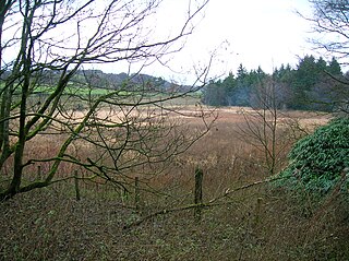
What now survives of the old Caprington Loch (NS402352) is situated near Earlston, Riccarton, East Ayrshire, Scotland. The loch was a natural feature, sitting in a hollow on the old Caprington Castle estate. The loch waters drain via the Todrigs Burn that flows into the River Irvine to the east of Gatehead village. It was partly drained, probably sometime after the 1820s, as were so many other lochs, as part of 18th and 19th centuries extensive agricultural improvements and the only area of open water that remains does so as it was once used as a curling pond for the Caprington Castle Estate owners and their employees or tenants.


